Vegetation productivity responses to drought on tribal lands in the four corners region of the Southwest USA
Mohamed Abd Salam EL-VILALY1(), Kamel DIDAN2, Stuart E. MARSH3, Willem J.D. VAN LEEUWEN3, Michael A. CRIMMINS4, Armando Barreto MUNOZ2
1. The International Food Policy Research Institute, Washington, DC 20006-1002, USA 2. Vegetation Index and Phenology Lab, Department of Agricultural and Biosystems Engineering, The University of Arizona, Tucson, AZ 85721-0036, USA 3. Arizona Remote Sensing Center, School of Natural Resources and the Environment, The University of Arizona, Tucson, AZ 85721-0043, USA 4. Department of Soils Water and Environmental Science, The University of Arizona, Tucson, AZ 85721-0038, USA
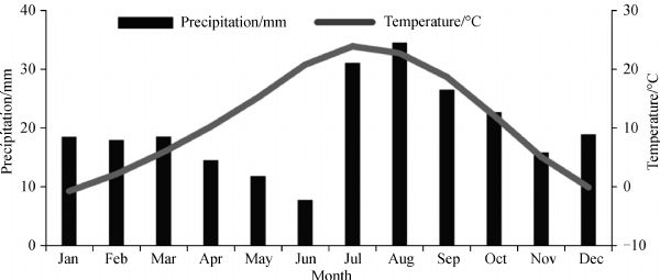
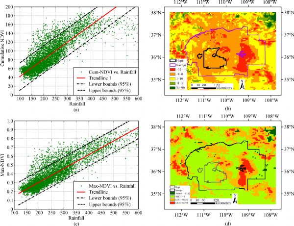
For more than a decade, the Four Corners Region has faced extensive and persistent drought conditions that have impacted vegetation communities and local water resources while exacerbating soil erosion. These persistent droughts threaten ecosystem services, agriculture, and livestock activities, and expose the hypersensitivity of this region to inter-annual climate variability and change. Much of the intermountain Western United States has sparse climate and vegetation monitoring stations, making fine-scale drought assessments difficult. Remote sensing data offers the opportunity to assess the impacts of the recent droughts on vegetation productivity across these areas. Here, we propose a drought assessment approach that integrates climate and topographical data with remote sensing vegetation index time series. Multi-sensor Normalized Difference Vegetation Index (NDVI) time series data from 1989 to 2010 at 5.6 km were analyzed to characterize the vegetation productivity changes and responses to the ongoing drought. A multi-linear regression was applied to metrics of vegetation productivity derived from the NDVI time series to detect vegetation productivity, an ecosystem service proxy, and changes. The results show that around 60.13% of the study area is observing a general decline of greenness (p<0.05), while 3.87% show an unexpected green up, with the remaining areas showing no consistent change. Vegetation in the area show a significant positive correlation with elevation and precipitation gradients. These results, while, confirming the region’s vegetation decline due to drought, shed further light on the future directions and challenges to the region’s already stressed ecosystems. Whereas the results provide additional insights into this isolated and vulnerable region, the drought assessment approach used in this study may be adapted for application in other regions where surface-based climate and vegetation monitoring record is spatially and temporally limited.
Corresponding Author(s):
Mohamed Abd Salam EL-VILALY
引用本文:
. [J]. Frontiers of Earth Science, 2018, 12(1): 37-51.
Mohamed Abd Salam EL-VILALY, Kamel DIDAN, Stuart E. MARSH, Willem J.D. VAN LEEUWEN, Michael A. CRIMMINS, Armando Barreto MUNOZ. Vegetation productivity responses to drought on tribal lands in the four corners region of the Southwest USA. Front. Earth Sci., 2018, 12(1): 37-51.
Alcaraz D, Paruelo J, Cabello J (2006). Identification of current ecosystem functional types in the Iberian Peninsula. Glob Ecol Biogeogr, 15(2): 200–212 https://doi.org/10.1111/j.1466-822X.2006.00215.x
2
Anyamba A, Tucker C (2005). Analysis of sahelian vegetation dynamics using NOAA-AVHRR NDVI data from 1981–2003. J Arid Environ, 63(3): 596–614 https://doi.org/10.1016/j.jaridenv.2005.03.007
3
Bainbridge D A (2012). Restoration of arid and semi-arid lands. Restoration Ecology: The New Frontier, 115
4
Below R, Grover-Kopec E, Dilley M (2007). Documenting drought-related disasters: a global reassessment. J Environ Dev, 16(3): 328–344 https://doi.org/10.1177/1070496507306222
5
Boschetti M, Nutini F, Brivio P A, Bartholomé E, Stroppiana D, Hoscilo A (2013). Identification of environmental anomaly hot spots in West Africa from time series of NDVI and rainfall. ISPRS Journal of Photogrammetry and Remote Sensing, 78: 26–40 https://doi.org/10.1016/j.isprsjprs.2013.01.003
6
Breshears D D, Cobb N S, Rich P M, Price K P, Allen C D, Balice R G, Romme W H, Kastens J H, Floyd M L, Belnap J, Anderson J J, Myers O B, Meyer C W (2005). Regional vegetation die-off in response to global-change-type drought. Proc Natl Acad Sci USA, 102(42): 15144–15148 https://doi.org/10.1073/pnas.0505734102
Cai X L, Sharma B R (2010). Integrating remote sensing, census and weather data for an assessment of rice yield, water consumption and water productivity in the indo-gangetic river basin. Agric Water Manage, 97(2): 309–316 https://doi.org/10.1016/j.agwat.2009.09.021
9
Cook E R, Woodhouse C A, Eakin C M, Meko D M, Stahle D W (2004). Long-term aridity changes in the western United States. Science, 306(5698): 1015–1018 https://doi.org/10.1126/science.1102586
10
Crimmins M A, Selover N, Cozzetto K, Chief K (2013). Technical Review of the Navajo Nation Drought Contingency Plan – Drought Monitoring. Meadow A M, ed. Tucson, AZ: Climate Assessment for the Southwest
11
Delbart N, Le Toan T, Kergoat L, Fedotova V (2006). Remote sensing of spring phenology in boreal regions: a free of snow-effect method using NOAA-AVHRR and SPOT-VGT data (1982–2004). Remote Sens Environ, 101(1): 52–62 https://doi.org/10.1016/j.rse.2005.11.012
12
Di Luzio M, Johnson G L, Daly C, Eischeid J K, Arnold J G (2008). Constructing retrospective gridded daily precipitation and temperature datasets for the conterminous United States. J Appl Meteorol Climatol, 47(2): 475–497 https://doi.org/10.1175/2007JAMC1356.1
13
Didan K (2010). Multi-satellite earth science data record for studying global vegetation trends and changes. In: Proceedings of the 2010 international geoscience and remote sensing symposium, Honolulu, HI, USA, (Vol. 2530, p. 2530).
14
Didan K, Barreto A M, Miura T, Tsend-Ayush J, Zhang X, Friedl M, Gray J, Van Leeuwen W, Czapla-Myers J, Doman B S, Jenkerson C, Maiersperger T, Meyer D (2016). Multi-Sensor Vegetation Index and Phenology Earth Science Data Records: Algorithm Theoretical Basis Document and User Guide Version 4.0 ()
15
Fang J, Piao S, Tang Z, Peng C, Ji W (2001). Interannual variability in net primary production and precipitation. Science, 293(5536): 1723 https://doi.org/10.1126/science.293.5536.1723a
16
Fensholt R, Langanke T, Rasmussen K, Reenberg A, Prince S D, Tucker C, Scholes R J, Le Q B, Bondeau A, Eastman R, Epstein H, Gaughan A E, Hellden U, Mbow C, Olsson L, Paruelo J, Schweitzer C, Seaquist J, Wessels K (2012). Greenness in semi-arid areas across the globe 1981–2007—An earth observing satellite based analysis of trends and drivers. Remote Sens Environ, 121: 144–158 https://doi.org/10.1016/j.rse.2012.01.017
17
Ferguson D, Crimmins M A (2009). Who’s paying attention to the drought on the Colorado Plateau. Southwest Climate Outlook, 3–6.
18
Gamon J A, Huemmrich K F, Stone R S, Tweedie C E (2013). Spatial and temporal variation in primary productivity (NDVI) of coastal alaskan tundra: decreased vegetation growth following earlier snowmelt. Remote Sens Environ, 129: 144–153 https://doi.org/10.1016/j.rse.2012.10.030
19
Garfin G, Ellis A, Selover N, Anderson D, Tecle A, Heinrich P, Crimmins M, Leeper J, Tallsalt-Robertson J, Harvey C (2007). Assessment of the Navajo Nation Hydroclimate Network: A Final Report–12/28/2007. Navajo Nation Department of Water Resources. Available on the web:
20
Gesch D B, Oimoen M J, Zhang Z, Meyer D J, Danielson J J (2012). Validation of the ASTER Global Digital Elevation Model Version 2 over the conterminous United States. In Imaging a sustainable future, 22nd Congress, 281–286
21
Grahame J D, Sisk T D (2002). Canyons, cultures and environmental change: an introduction to the land-use history of the Colorado Plateau. The Land Use History of North America Program, United States Geological Survey
22
Gray S T, Betancourt J L, Fastie C L, Jackson S T (2003). Patterns and sources of multidecadal oscillations in drought-sensitive tree-ring records from the central and southern Rocky Mountains. Geophys Res Lett, 30(6), https://doi.org/10.1029/2002GL016154
23
Griffin D, Woodhouse C A, Meko D M, Stahle D W, Faulstich H L, Carrillo C, Touchan R, Castro C L, Leavitt S W (2013). North American monsoon precipitation reconstructed from tree-ring latewood. Geophys Res Lett, 40(5): 954–958 https://doi.org/10.1002/grl.50184
24
Herrmann S M, Didan K, Barreto-Munoz A, Crimmins M A (2016). Divergent responses of vegetation cover in Southwestern US ecosystems to dry and wet years at different elevations. Environ Res Lett, 11(12): 124005 https://doi.org/10.1088/1748-9326/11/12/124005
25
Horion S, Cornet Y, Erpicum M, Tychon B (2012). Studying interactions between climate variability and vegetation dynamic using a phenology based approach. Int J Appl Earth Obs Geoinf, 20(1): 20–32
26
Huete A R, Restrepo-Coupe N, Ratana P, Didan K, Saleska S R, Ichii K, Panuthai S, Gamo M (2008). Multiple site tower flux and remote sensing comparisons of tropical forest dynamics in Monsoon Asia. Agricultural and Forest Meteorology, 148(5), pp.748–760.
27
Jolly W M, Dobbertin M, Zimmermann N E, Reichstein M (2005). Divergent vegetation growth responses to the 2003 heat wave in the Swiss Alps. Geophys Res Lett, 32(18), https://doi.org/10.1029/2005GL023252
28
Kaplan S (2012a). Response of urban and non-urban land cover in a semi-arid ecosystem to summer precipitation variability. J Ariz Nev Acad Sci, 43(2): 77–85 https://doi.org/10.2181/036.043.0203
29
Karnieli A (2003). Natural vegetation phenology assessment by ground spectral measurements in two semi-arid environments. Int J Biometeorol, 47(4): 179–187 https://doi.org/10.1007/s00484-003-0169-z
Liang T, Feng Q, Yu H, Huang X, Lin H, An S, Ren J (2012). Dynamics of natural vegetation on the Tibetan Plateau from past to future using a comprehensive and sequential classification system and remote sensing data. Grassland science, 58(4): 208–220
Ma M, Frank V (2006). Interannual variability of vegetation cover in the chinese heihe river basin and its relation to meteorological parameters. Int J Remote Sens, 27(16): 3473–3486 https://doi.org/10.1080/01431160600593031
34
Mu Q, Zhao M, Kimball J S, McDowell N G, Running S W (2013). A remotely sensed global terrestrial drought severity index. Bulletin of the American Meteorological Society, 94(1): 83–98
35
NALCMS (2005). North American Land Cover at 250 m spatial resolution. Produced by Natural Resources Canada/Canadian Center for Remote Sensing (NRCan/CCRS), United States Geological Survey (USGS); Insituto Nacional de Estadística y Geografía (INEGI), Comisión Nacional para el Conocimiento y Uso de la Biodiversidad (CONABIO) and Comisión Nacional Forestal CONAFOR).
36
NCAR (2005). The US National Center for Atmospheric Research (NCAR) and the University Corporation for Atmospheric Research (UCAR);"drought's growing reach: national center for atmospheric research study points to global warming as key factor".
37
Nemani R R, Keeling C D, Hashimoto H, Jolly W M, Piper S C, Tucker C J, Myneni R B, Running S W (2003). Climate-driven increases in global terrestrial net primary production from 1982 to 1999. Science, 300(5625): 1560–1563 https://doi.org/10.1126/science.1082750
38
Nicholson S E, Farrar T J (1994). The influence of soil type on the relationships between NDVI, precipitation, and soil moisture in semiarid Botswana. I. NDVI response to precipitation. Remote Sens Environ, 50(2): 107–120 https://doi.org/10.1016/0034-4257(94)90038-8
39
Nieto S, Flombaum P, Garbulsky M F (2015). Can temporal and spatial NDVI predict regional bird-species richness? Global Ecology and Conservation, 3: 729–735 https://doi.org/10.1016/j.gecco.2015.03.005
Ouyang W, Hao F, Skidmore A K, Groen T A, Toxopeus A G, Wang T (2012). Integration of multi-sensor data to assess grassland dynamics in a Yellow River sub-watershed. Ecol Indic, 18: 163–170 https://doi.org/10.1016/j.ecolind.2011.11.013
Pape Mş, Peterson A T, Powell G V N (2012). Vegetation dynamics and avian seasonal migration: clues from remotely sensed vegetation indices and ecological niche modelling. J Biogeogr, 39(4): 652–664 https://doi.org/10.1111/j.1365-2699.2011.02632.x
44
Peng Y, Gitelson A A, Sakamoto T (2013). Remote estimation of gross primary productivity in crops using MODIS 250 m data. Remote Sens Environ, 128: 186–196 https://doi.org/10.1016/j.rse.2012.10.005
45
Pôças I, Cunha M, Pereira L S, Allen R G (2013). Using remote sensing energy balance and evapotranspiration to characterize montane landscape vegetation with focus on grass and pasture lands. Int J Appl Earth Obs Geoinf, 21: 159–172 https://doi.org/10.1016/j.jag.2012.08.017
46
Reynolds J F, Stafford S D M, Olsson L (2003). Geographical reviews-global desertification: Do humans cause deserts? Geogr Rev, 93(3): 413
47
Ryu Y, Baldocchi D D, Verfaillie J, Ma S, Falk M, Ruiz-Mercado I, Hehn T, Sonnentag O (2010). Testing the performance of a novel spectral reflectance sensor, built with light emitting diodes (LEDs), to monitor ecosystem metabolism, structure and function. Agric Meteorol, 150(12): 1597–1606 https://doi.org/10.1016/j.agrformet.2010.08.009
48
Shafer B A, Dezman L E (1982). Development of a Surface Water Supply Index (SWSI) to assess the severity of drought conditions in snowpack runoff areas. In: Proceedings of the western snow conference. Vol. 50. Fort Collins, CO: Colorado State University
49
Shi J, Jackson T, Tao J, Du J, Bindlish R, Lu L, Chen K S (2008). Microwave vegetation indices for short vegetation covers from satellite passive microwave sensor AMSR-E. Remote Sens Environ, 112(12): 4285–4300 https://doi.org/10.1016/j.rse.2008.07.015
50
Sivakumar M, Motha R, Wilhite D, Wood D (2010). Agricultural Drought Indices Proceedings of An Expert Meeting 2–4 June 2010, Murcia, Spain. Geneva: World Meteorological Organization, 219
51
UNDP/UNSO (1997). Aridity zones and dryland populations: an assessment of population levels in the world’s drylands. New York: Office to Combat Desertification and Drought
52
UNESCO (2012). World water development report managing water under uncertainty and risk. The United Nations world water development report 4. World water assessment programme.
53
Wang J, Rich P M, Price K P (2003). Temporal responses of NDVI to precipitation and temperature in the central Great Plains, USA. Int J Remote Sens, 24(11): 2345–2364 https://doi.org/10.1080/01431160210154812
54
Wang Y (2012). Detecting vegetation recovery patterns after hurricanes in south florida using NDVI time series. Open Access Theses. Paper 355
55
Weiss J, Gutzler D S, Coonrod J E A, Dahm C N (2004). Long-term vegetation monitoring with NDVI in a diverse semi-arid setting, central New Mexico, USA. J Arid Environ, 58(2): 249–272 https://doi.org/10.1016/j.jaridenv.2003.07.001
56
Wessels K J, Prince S D, Malherbe J, Small J, Frost P, VanZyl D (2007). Can human-induced land degradation be distinguished from the effects of rainfall variability? A case study in South Africa. J Arid Environ, 68(2): 271–297 https://doi.org/10.1016/j.jaridenv.2006.05.015
57
White M A, Nemani R R (2006). Real-time monitoring and short-term forecasting of land surface phenology. Remote Sens Environ, 104(1): 43–49 https://doi.org/10.1016/j.rse.2006.04.014
58
Wright C K, de Beurs K M, Henebry G M (2012). Combined analysis of land cover change and NDVI trends in the Northern Eurasian grain belt. Front Earth Sci, 6(2): 177–187
59
Yin H, Udelhoven T, Fensholt R, Pflugmacher D, Hostert P (2012). How normalized difference vegetation index (NDVI) trendsfrom advanced very high resolution radiometer (AVHRR) and système probatoire d’observation de la terre vegetation (SPOT VGT) time series differ in agricultural areas: An inner Mongolian case study. Remote Sens, 4(11): 3364–3389 https://doi.org/10.3390/rs4113364
60
Yuan F, Roy S S (2007). Analysis of the relationship between NDVI and climate variables in minnesota using geographically weighted regression and spatial interpolation. In American Society for Photogrammetry and Remote Sensing- ASPRS Annual Conference 2007: Identifying Geospatial Solutions, 2: 784–789
61
Zhang X, Friedl M A, Schaaf C B, Strahler A H (2004). Climate controls on vegetation phenological patterns in northern mid- and high latitudes inferred from MODIS data. Glob Change Biol, 10(7): 1133–1145 https://doi.org/10.1111/j.1529-8817.2003.00784.x