|
|
|
The barrier river reach identification and classification in the Middle Yangtze River |
Jinwu TANG1, Chunyan HU1, Xingying YOU2,3( ), Yunping YANG4, Xiaofeng ZHANG3, Jinyun DENG3, Meng CHEN2 ), Yunping YANG4, Xiaofeng ZHANG3, Jinyun DENG3, Meng CHEN2 |
1. Changjiang Institute of Survey Planning Design and Research, Wuhan 430010, China
2. Hubei Institute of Survey & Design for Water Resources & Water Power Engineering, Wuhan 430064, China
3. State Key Laboratory of Water Resource and Hydropower Engineering Science, Wuhan University, Wuhan 430072, China
4. Key Laboratory of Engineering Sediment, Tianjin Research Institute for Water Transport Engineering, Ministry of Transport, Tianjin 300456, China |
|
|
|
|
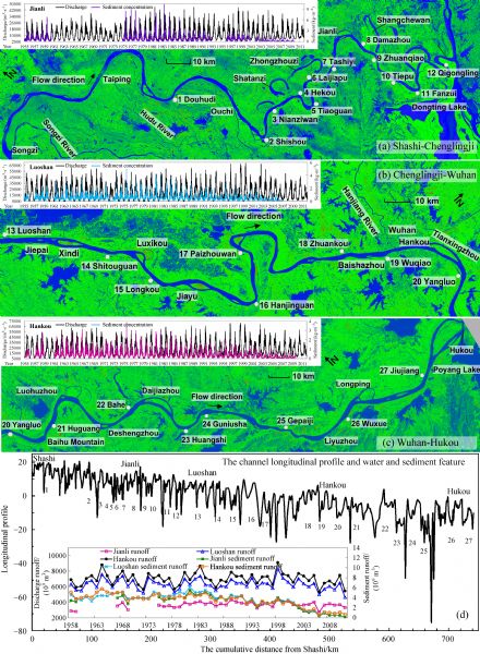
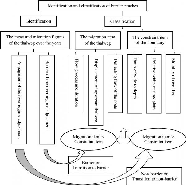
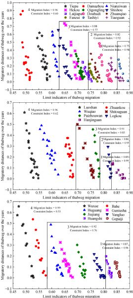
Abstract Adjustments of upstream river regimes are one of the main factors affecting downstream fluvial processes. However, not all adjustments of river regimes will propagate downstream. There are some distinctive river reaches where upstream and downstream adjustments have no relevance. However, the irrelevance is neither caused by different river types nor by the different conditions of water and sediment; but rather, the channel boundaries and riverbed morphologies block the propagation effect. These are referred to here as the barrier river reach phenomena. The migration of the thalweg line is the essential reason for causing the propagation effect. Numerous influencing factors for thalweg migration exist, including 1) the average flow rate above the critical bankfull discharge, the average flow rate below the critical bankfull discharge, and their ratio, 2) the ratio of the duration of the aforementioned two periods, 3) the thalweg displacement at the entrance of the river reach, 4) the deflecting flow intensity of the node, 5) the ratio of the river width to water depth, 6) the relative width of the floodplain, and 7) the Shields number. In this study, the correlativity between the measured distances and the restricting indicators of thalweg migration in the Middle Yangtze River over the years was established. The barrier degree of 27 single-thread river reaches was subsequently assessed. These reaches included 4 barrier river reaches; 5 transitional reaches transforming from barrier to non-barrier; 10 transitional reaches transforming from non-barrier to barrier; and 8 non-barrier river reaches. Barrier river reaches were found to be important for maintaining the stability of the river regime and the transverse equilibrium of sediment transport in the downstream reaches. To some extent, the barrier river reaches may protect the natural dynamical properties from being destroyed by artificial river regulation works. Thus, they are of great significance for river management.
|
| Keywords
the barrier river reach
Yangtze River
channel adjustment
thalweg migration
identification and classification
|
|
Corresponding Author(s):
Xingying YOU
|
|
Just Accepted Date: 15 March 2018
Online First Date: 01 April 2019
Issue Date: 15 October 2019
|
|
| 1 |
I Armaş, D E Gogoaşe Nistoran, G Osaci-Costache, L Braşoveanu (2013). Morpho-dynamic evolution patterns of Subcarpathian Prahova River (Romania). Catena, 100(2): 83–99
https://doi.org/10.1016/j.catena.2012.07.007
|
| 2 |
D Campana, E Marchese, J I Theule, F Comiti (2014). Channel degradation and restoration of an alpine river and related morphological changes. Geomorphology, 221(11): 230–241
https://doi.org/10.1016/j.geomorph.2014.06.016
|
| 3 |
J Chen, Z Wang, M Li, T Wei, Z Chen (2012). Bedform characteristics during falling flood stage and morphodynamic interpretation of the middle–lower Changjiang (Yangtze) River channel, China. Geomorphology, 147–148: 18–26
https://doi.org/10.1016/j.geomorph.2011.06.042
|
| 4 |
Á Cserkész-Nagy, T Tóth, Ö Vajk, O Sztanó (2010). Erosional scours and meander development in response to river engineering: middle Tisza region, Hungary. Proceedings of the Geologists’ Association, 121(2): 238–247
https://doi.org/10.1016/j.pgeola.2009.12.002
|
| 5 |
M David, A Labenne, J M Carozza, P Valette (2016). Evolutionary trajectory of channel planforms in the middle Garonne River (Toulouse, SW France) over a 130-year period: contribution of mixed multiple factor analysis (MFAmix). Geomorphology, 258: 21–39
https://doi.org/10.1016/j.geomorph.2016.01.012
|
| 6 |
W M Davis (1899). The geographical cycle. The Geographical Journal. Washington, 14(5): 481
https://doi.org/org/10.2307/1774538
|
| 7 |
P W Downs, K J Gregory (1993). The sensitivity of river channels in the landscape system. In: Thomas D S G, Allison R J, eds. Landscape Sensitivity. Chichester: Wiley, 15–30
|
| 8 |
R I Ferguson (1981). Channel form and channel changes. In: Lewin J, ed. British River. Longdon: Allen and Unwin, 90–211
|
| 9 |
R M Frings, R Döring, C Beckhausen, H Schüttrumpf, S Vollmer (2014). Fluvial sediment budget of a modern, restrained river: the lower reach of the Rhine in Germany. Catena, 122(12): 91–102
https://doi.org/10.1016/j.catena.2014.06.007
|
| 10 |
K A Fryirs, G J Brierley, N J Preston, J Spencer (2007). Catchment-scale (dis)connectivity in sediment flux in the upper Hunter catchment, New South Wales, Australia. Geomorphology, 84(3–4): 297–316
https://doi.org/10.1016/j.geomorph.2006.01.044
|
| 11 |
G K Gilbert, C E Dutton (1877). Report on the geology of the Henry Mountains. Geographical and Geological Survey of the Rocky Mountain Region (U.S.)
https://doi.org/org/10.5962/bhl.title.51652
|
| 12 |
S L Goodbred Jr, S A Kuehl (1998). Floodplain processes in the Bengal Basin and the storage of Ganges—Brahmaputra river sediment: an accretion study using 137Cs and 210Pb geochronology. Sediment Geol, 121(3–4): 239–258
https://doi.org/10.1016/S0037-0738(98)00082-7
|
| 13 |
J T Hack (1960). Interpretation of erosional topography in humid temperate regions. American Journal of Science, 258-A: 80–97
|
| 14 |
H Hajdukiewicz, B Wyżga, P Mikuś, J Zawiejska, A Radecki-Pawlik (2016). Impact of a large flood on mountain river habitats, channel morphology, and valley infrastructure. Geomorphology, 272: 55–67
|
| 15 |
Q W Han (2011). Equilibrium trend of sediment transportation and river morphology. J Sediment Res, 8(4): 1–14 (in Chinese)
|
| 16 |
A J Henshaw, A M Gurnell, W Bertoldi, N A Drake (2013). An assessment of the degree to which Landsat TM data can support the assessment of fluvial dynamics, as revealed by changes in vegetation extent and channel position, along a large river. Geomorphology, 202: 74–85
https://doi.org/10.1016/j.geomorph.2013.01.011
|
| 17 |
X Q Huang, Z J Liu (1991). A study on the inner structure and spatial effect of the braided pattern in the lower reaches of the Chang Jiang (Yangzi River). Acta Geographica Sinica, (2): 169–177 (in Chinese)
|
| 18 |
Q Jun, Z F Yang, Z Y Shen (2012). Three-dimensional modeling of sediment transport in the Wuhan catchments of the Yangtze River. Procedia Environ Sci, 13: 2437–2444
https://doi.org/10.1016/j.proenv.2012.01.232
|
| 19 |
A Kidová, M Lehotská, M Rusnák (2016). Geomorphic diversity in the braided-wandering Belá River, Slovak Carpathians, as a response to flood variability and environmental changes. Geomorphology, 272: 137–149
https://doi.org/org/10.1016/j.geomorph.2016.01.002
|
| 20 |
L B Leopold, M G Wolman (1957). River channel patterns- braided, meandering, and straight. The Professional Geographer, 9: 39–85
|
| 21 |
B R Li, Y L Yao (1965). Calculation method of longitudinal gradient and longitudinal profile. Yellow River, 4: 32–36 (in Chinese)
|
| 22 |
G Lobera, P Besné, D Vericat, J A López-Tarazón, A Tena, I Aristi, J R Díez, A Ibisate, A Larrañaga, A Elosegi, R J Batalla (2015). Geomorphic status of regulated rivers in the Iberian Peninsula. Sci Total Environ, 508(508C): 101–114
https://doi.org/10.1016/j.scitotenv.2014.10.058
|
| 23 |
G C Nanson, J C Croke (1992). A genetic classification of floodplains. Geomorphology, 4(6): 459–486
https://doi.org/10.1016/0169-555X(92)90039-Q
|
| 24 |
R A Nanson, G C Nanson, H Q Huang (2010). The hydraulic geometry of narrow and deep channels; evidence for flow optimisation and controlled peatland growth. Geomorphology, 117(1–2): 143–154
https://doi.org/10.1016/j.geomorph.2009.11.021
|
| 25 |
N Qian, R Zhang , Z D Zhou (1987). Fluvial Process. Beijing: Science Press (in Chinese)
|
| 26 |
J Ramos, J Gracia (2012). Spatial-temporal fluvial morphology analysis in the Quelite river: it’s impact on communication systems. J Hydrol (Amst), 412–413: 269–278
https://doi.org/10.1016/j.jhydrol.2011.05.007
|
| 27 |
H E Reid, G J Brierley (2015). Assessing geomorphic sensitivity in relation to river capacity for adjustment. Geomorphology, 251: 108–121
https://doi.org/10.1016/j.geomorph.2015.09.009
|
| 28 |
S Roy, A S Sahu (2015). Quaternary tectonic control on channel morphology over sedimentary low land: a case study in the Ajay-Damodar interfluve of Eastern India. Geoscience Frontiers, 6(6): 927–946
https://doi.org/10.1016/j.gsf.2015.04.001
|
| 29 |
B R Rust (1977). A classification of alluvial channel systems. Dallas Geological Society, 1977: 187–198
|
| 30 |
S A Schumm (1985). Patterns of alluvial rivers. Annual Review of Earth and Planetary Sciences, 13(1): 5–27
https://doi.org/org/10.1146/annurev.earth.13.1.5
|
| 31 |
S A Schumm, H R Khan (1971). Experimental Study of Channel Patterns. Nature, 233(5319): 407–409
https://doi.org/org/10.2110/scn.85.19.0083
|
| 32 |
F Schuurman, M G Kleinhans, H Middelkoop (2016a). Network response to disturbances in large sand-bed braided rivers. Earth Surface Dynamics, 4(1): 25–45
https://doi.org/org/10.5194/esurf-4-25-2016
|
| 33 |
F Schuurman, Y Shimizu, T Iwasaki, M G Kleinhans (2016b). Dynamic meandering in response to upstream perturbations and floodplain formation. Geomorphology, 253: 94–109
https://doi.org/org/10.1016/j.geomorph.2015.05.039
|
| 34 |
X L Song, G Q, Xu Y C Bai, D Xu (2016). Experiments on the short-term development of sine-generated meandering rivers. Journal of Hydro-environment Research, 11: 42–58
https://doi.org/org/10.1016/j.jher.2016.01.004
|
| 35 |
J Sun, B L Lin, H Y Yang (2015). Development and application of a braided river model with non-uniform sediment transport. Advances in Water Resources, 81(45): 62–74
https://doi.org/10.1016/j.advwatres.2014.12.012
|
| 36 |
J B Thayer, P Ashmore (2016). Floodplain morphology, sedimentology, and development processes of a partially alluvial channel. Geomorphology, 269: 160–174
https://doi.org/10.1016/j.geomorph.2016.06.040
|
| 37 |
W M van Dijk, F Schuurman, W I van de Lageweg, M G Kleinhans (2014). Bifurcation instability and chute cutoff development in meandering gravel-bed rivers. Geomorphology, 213: 277–291
https://doi.org/10.1016/j.geomorph.2014.01.018
|
| 38 |
W M van Dijk, W I van de Lageweg, M G Kleinhans (2013). Formation of a cohesive floodplain in a dynamic experimental meandering river. Earth Surface Processes and Landforms, 38(13): 1550–1565
https://doi.org/org/10.1002/esp.3400
|
| 39 |
S J Wang (2003). Architectures, relationships between discharges and width/depth ratios of stream cross profiles, and stream powers of anastomosing rivers. Acta Sedimentologica Sinica, 21(4): 565–564 (in Chinese)
|
| 40 |
S J Wang, S P Yin (2000). Discussion on channel patterns of anastomosing and anabranched rivers. Earthence Frontiers, (b08): 79–86 (in Chinese)
|
| 41 |
E Wohl (2015). Particle dynamics: the continuum of bedrock to alluvial river segments. Geomorphology, 241: 192–208
https://doi.org/10.1016/j.geomorph.2015.04.014
|
| 42 |
M G Wolman, R Gerson (1978). Relative scales of time and effectiveness of climate in watershed geomorphology. Earth Surface Processes, 3(2): 189–208
https://doi.org/10.1002/esp.3290030207
|
| 43 |
J Q Xia, S S Deng, J Y Lu, Q X Xu, Q L Zong, G M Tan (2016). Dynamic channel adjustments in the Jingjiang Reach of the Middle Yangtze River. Scientific Reports, 6(1): 1–10
https://doi.org/org/10.1038/srep22802
|
| 44 |
J Q Xia, Q L Zong, S S Deng, Q X Xu, J Y Lu (2014). Seasonal variations in composite riverbank stability in the Lower Jingjiang Reach, China. Journal of Hydrology, 519: 3664–3673
https://doi.org/10.1016/j.jhydrol.2014.10.061
|
| 45 |
D Xu, Y C Bai(2013). Experimental study on the bed opography evolution in alluvial meandering rivers with various sinuousnesses. Journal of Hydro-environment Research, 7(2): 92–102
https://doi.org/10.1016/j.jher.2012.06.003
|
| 46 |
X Y You, J W Tang (2017b). Phenomena and characteristics of barrier river reaches in the middle and lower Yangtze River, China. Journal of Earth System Science, 126(4): 61
https://doi.org/org/10.1007/s12040-017-0831-1
|
| 47 |
X Y You, J W Tang, X F Zhang, W G Hou, Y P Yang, Z H Sun, Z H Weng, (2017a). The mechanism of barrier river reaches in the middle and lower Yangtze River. Journal of Geographical Sciences, 27(10): 1249–1267
https://doi.org/10.1007/s11442-017-1433-1
|
| 48 |
X Y You, J W Tang, X F Zhang, Y T Li (2016). Preliminary study on the characteristics and origin of barrier river reach in the Middle and Lower Yangtze River. Journal of Hydraulic Engineering, 47(4): 545–551
|
| 49 |
W Zhang, Y P Yang, M J Zhang, Y T Li, L L Zhu, X Y You, D Wang, J F Xu, (2017). Mechanisms of suspended sediment restoration and bed level compensation in downstream reaches of the Three Gorges Projects (TGP). Journal of Geographical Sciences, 27(4): 463–480
https://doi.org/10.1007/s11442-017-1387-3
|
| 50 |
G Zolezzi, I Güneralp (2016). Continuous wavelet characterization of the wavelengths and regularity of meandering rivers. Geomorphology, 252(3): 98–111
https://doi.org/10.1016/j.geomorph.2015.07.029
|
|
Viewed |
|
|
|
Full text
|
|
|
|
|
Abstract
|
|
|
|
|
Cited |
|
|
|
|
| |
Shared |
|
|
|
|
| |
Discussed |
|
|
|
|