Please wait a minute...
Frontiers of Earth Science

ISSN 2095-0195

ISSN 2095-0209(Online)

CN 11-5982/P

Postal Subscription Code 80-963

2018 Impact Factor: 1.205

Front Earth Sci    0, Vol. Issue () : 276-282    https://doi.org/10.1007/s11707-012-0323-1
RESEARCH ARTICLE
Development and prospects of the fire space monitoring system in Kazakhstan
Lev SPIVAK, Oleg ARKHIPKIN(), Gulshat SAGATDINOVA
Space Research Institute, National Center of Space Research and Technology, Shevchenko, Almaty 050010, Kazakhstan
 Download: PDF(5912 KB)   HTML
 Export: BibTeX | EndNote | Reference Manager | ProCite | RefWorks
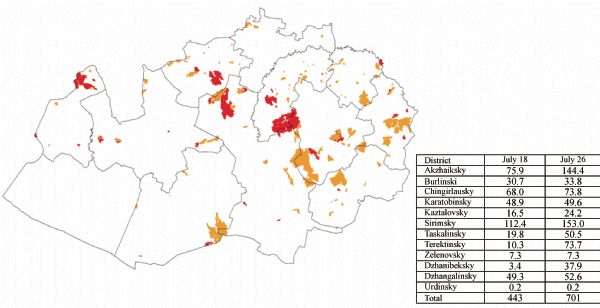
Abstract

This article provides a brief description of the fire space monitoring system in Kazakhstan, including the GIS-technology incorporated in its structure. The system performs operative space monitoring of fire areas and burnt areas, mapping of large fire areas, analysis of seasonal and long-term dynamics of burnt areas, and estimation of fire risk zones. Examples of output information obtained from space monitoring of fires are given. Possible directions of development of fire space monitoring in Kazakhstan are specified.

Keywords space images      remote sensing      fire space monitoring      fire areas      burnt areas      operating mapping      zones of high fire risk     
Corresponding Author(s): ARKHIPKIN Oleg,Email:mkmikikz@rambler.ru   
Issue Date: 05 September 2012
 Cite this article:   
Lev SPIVAK,Oleg ARKHIPKIN,Gulshat SAGATDINOVA. Development and prospects of the fire space monitoring system in Kazakhstan[J]. Front Earth Sci, 0, (): 276-282.
 URL:  
https://academic.hep.com.cn/fesci/EN/10.1007/s11707-012-0323-1
https://academic.hep.com.cn/fesci/EN/Y0/V/I/276
Fig.1  Fire area output information. Aktubinsky region, data for July 26, 2009
Fig.2  Burnt area output information. West Kazakhstan region, data for July 26, 2009
Fig.3  Results of large fire area monitoring in Kazakhstan during the fire dangerous season, May to July of 2009. (a) Map of large fires centers, (b) Diagram of the number of large fire areas divided by the regions of Kazakhstan
Fig.4  Dynamic of burnt areas in the West Kazakhstan region in 2001-2009 (a), Aktyubinsk region in 2003-2009 (b) and Karaganda region in 2005-2009 (c)
Fig.5  Estimation of fire risk zones on the territory of three districts in the West Kazakhstan region by fire space monitoring data for 2002-2008
Fig.6  Areas affected for the least time (green color) during the period 2002-2008, information gathered from remote sensing data
Fig.7  High-degree fire risk zones of the West Kazakhstan region for 2002-2008. Areas have experienced burning three or more times.
1 Spivak L F, Arkhipkin O P, Shagarova L V, Batyrbaeva M J (2003a). Fire space monitoring system in Kazakhstan. In: Proceedings of IGARSS’2003 of Geoscience and Remote Sensing IEEE International Symposium, 21-25 July, Toulouse, France
2 Spivak L F, Arkhipkin O P, Shagarova L V, Batyrbaeva M J (2003b). About fire space monitoring in Kazakhstan. Research of the Earth from Space , 3: 93-94 (in Russian)
3 Spivak L F, Arkhipkin O P, Sagatdinova G N (2005). Development of fires space monitoring system in Kazakhstan. In: Proceedings of 31st International Symposium on Remote Sensing of Environment, 20-24 June, St. Petersburg, Russia
[1] Chao WANG, Zhiyuan LI, Xiong XU, Xiangsui ZENG, Jia LI, Huan XIE, Yanmin JIN, Xiaohua TONG. Performance of the Large Field of View Airborne Infrared Scanner and its application potential in land surface temperature retrieval[J]. Front. Earth Sci., 2023, 17(2): 378-390.
[2] Boling YIN, Dongjie GUAN, Yuxiang ZHANG, He XIAO, Lidan CHENG, Jiameng CAO, Xiangyuan SU. How to accurately extract large-scale urban land? Establishment of an improved fully convolutional neural network model[J]. Front. Earth Sci., 2022, 16(4): 1061-1076.
[3] Herrieth MACHIWA, Bo TIAN, Dhritiraj SENGUPTA, Qian CHEN, Michael MEADOWS, Yunxuan ZHOU. Vegetation dynamics in response to human and climatic factors in the Tanzanian Coast[J]. Front. Earth Sci., 2021, 15(3): 595-605.
[4] Sijun ZHENG, Chen MENG, Jianhui XUE, Yongbo WU, Jing LIANG, Liang XIN, Lang ZHANG. UAV-based spatial pattern of three-dimensional green volume and its influencing factors in Lingang New City in Shanghai, China[J]. Front. Earth Sci., 2021, 15(3): 543-552.
[5] Conghui LI, Lili LIN, Zhenbang HAO, Christopher J. POST, Zhanghao CHEN, Jian LIU, Kunyong YU. Developing a USLE cover and management factor (C) for forested regions of southern China[J]. Front. Earth Sci., 2020, 14(3): 660-672.
[6] Emre ÇOLAK, Filiz SUNAR. Spatial pattern analysis of post-fire damages in the Menderes District of Turkey[J]. Front. Earth Sci., 2020, 14(2): 446-461.
[7] Xia LEI, Jiayi PAN, Adam DEVLIN. An ultraviolet to visible scheme to estimate chromophoric dissolved organic matter absorption in a Case-2 water from remote sensing reflectance[J]. Front. Earth Sci., 2020, 14(2): 384-400.
[8] Jianhong LIU, Clement ATZBERGER, Xin HUANG, Kejian SHEN, Yongmei LIU, Lei WANG. Modeling grass yields in Qinghai Province, China, based on MODIS NDVI data—an empirical comparison[J]. Front. Earth Sci., 2020, 14(2): 413-429.
[9] Tong LI, Huadong GUO, Li ZHANG, Chenwei NIE, Jingjuan LIAO, Guang LIU. Simulation of Moon-based Earth observation optical image processing methods for global change study[J]. Front. Earth Sci., 2020, 14(1): 236-250.
[10] Kaiguo FAN, Huaguo ZHANG, Jianjun LIANG, Peng CHEN, Bojian XU, Ming ZHANG. Analysis of ship wake features and extraction of ship motion parameters from SAR images in the Yellow Sea[J]. Front. Earth Sci., 2019, 13(3): 588-595.
[11] Shichao CUI, Kefa ZHOU, Rufu DING, Guo JIANG. Estimation of copper concentration of rocks using hyperspectral technology[J]. Front. Earth Sci., 2019, 13(3): 563-574.
[12] Ying XIONG, Fen PENG, Bin ZOU. Spatiotemporal influences of land use/cover changes on the heat island effect in rapid urbanization area[J]. Front. Earth Sci., 2019, 13(3): 614-627.
[13] Igor Appel. Uncertainty in satellite remote sensing of snow fraction for water resources management[J]. Front. Earth Sci., 2018, 12(4): 711-727.
[14] Donal O’Leary III, Dorothy Hall, Michael Medler, Aquila Flower. Quantifying the early snowmelt event of 2015 in the Cascade Mountains, USA by developing and validating MODIS-based snowmelt timing maps[J]. Front. Earth Sci., 2018, 12(4): 693-710.
[15] Zhen LI, Jinghu PAN. Spatiotemporal changes in vegetation net primary productivity in the arid region of Northwest China, 2001 to 2012[J]. Front. Earth Sci., 2018, 12(1): 108-124.
Viewed
Full text


Abstract

Cited

  Shared   
  Discussed