|
|
|
Mapping of wind energy potential over the Gobi Desert in Northwest China based on multiple sources of data |
Li LI1,2,3, Xinyuan WANG1,3( ), Lei LUO1,2,3, Yanchuang ZHAO1,2,3, Xin ZONG1,2,3, Nabil BACHAGHA1,2,3 ), Lei LUO1,2,3, Yanchuang ZHAO1,2,3, Xin ZONG1,2,3, Nabil BACHAGHA1,2,3 |
1. Key Laboratory of Digital Earth Science, Institute of Remote Sensing and Digital Earth, Chinese Academy of Sciences, Beijing 100094, China
2. University of Chinese Academy of Sciences, Beijing 100049, China
3. International Centre on Space Technologies for Natural and Cultural Heritage, Beijing 100094, China |
|
|
|
|
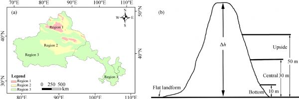
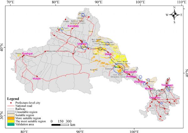
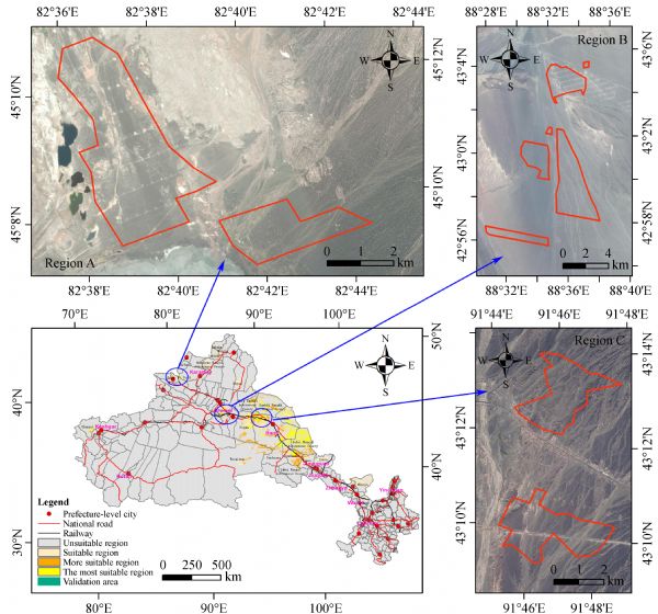
Abstract In recent years, wind energy has been a fast-growing alternative source of electrical power due to its sustainability. In this paper, the wind energy potential over the Gobi Desert in Northwest China is assessed at the patch scale using geographic information systems (GIS). Data on land cover, topography, and administrative boundaries and 11 years (2000–2010) of wind speed measurements were collected and used to map and estimate the region’s wind energy potential. Based on the results, it was found that continuous regions of geographical potential (GeoP) are located in the middle of the research area (RA), with scattered areas of similar GeoP found in other regions. The results also show that the technical potential (TecP) levels are about 1.72–2.67 times (2.20 times on average) higher than the actual levels. It was found that the GeoP patches can be divided into four classes: unsuitable regions, suitable regions, more suitable regions, and the most suitable regions. The GeoP estimation shows that 0.41 billion kW of wind energy are potentially available in the RA. The suitable regions account for 25.49%, the more suitable regions 24.45%, and the most suitable regions for more than half of the RA. It is also shown that Xinjiang and Gansu are more suitable for wind power development than Ningxia.
|
| Keywords
wind energy
alternative energy
sustainability
Northwest China
Gobi Desert
|
|
Corresponding Author(s):
Xinyuan WANG
|
|
Just Accepted Date: 25 September 2017
Online First Date: 31 October 2017
Issue Date: 09 May 2018
|
|
| 1 |
Al-Nassar W, Alhajraf S, Al-Enizi A, Al-Awadhi L (2005). Potential wind power generation in the State of Kuwait. Renew Energy, 30(14): 2149–2161
https://doi.org/10.1016/j.renene.2005.01.002
|
| 2 |
Bailey B H, McDonald S L, Markus M J, Elsholz K V (1997). Wind Resource Assessment Handbook: Fundamentals for Conducting a Successful Monitoring Program. New York: AWS Scientific, Inc.
|
| 3 |
Bao N, Liu J, Ni W, Ye Z (2006). Wind energy resource analysis at Debauching wind farm in Xinjiang region. Acta Energize Solaris Sinica, 27: 1073–1077 (in Chinese)
|
| 4 |
Burrough P A, McDonell R A (1998). Principles of Geographical Information Systems. Oxford University Press
|
| 5 |
Chang R, Zhu R, Merete B, Charlotte B H, Xing X, Jiang Y (2015). Offshore Wind Resources Assessment from Multiple Satellite Data and WRF Modeling over South China Sea. Remote Sens, 7(1): 467–487
https://doi.org/10.3390/rs70100467
|
| 6 |
Chock G Y K, Cochran L (2005). Modeling of topographic wind speed effects in Hawaii. J Wind Eng Ind Aerodyn, 93(8): 623–638
https://doi.org/10.1016/j.jweia.2005.06.002
|
| 7 |
Dabbaghiyan A, Fazelpour F, Abnavi M D, Rosen M A (2016). Evaluation of wind energy potential in province of Bushehr, Iran. Renew Sustain Energy Rev, 55: 455–466
https://doi.org/10.1016/j.rser.2015.10.148
|
| 8 |
De Araujo Lima L, Bezerra Filho C R (2010). Wind energy assessment and wind farm simulation in Triunfo-Pernambuco, Brazil. Renew Energy, 35(12): 2705–2713
https://doi.org/10.1016/j.renene.2010.04.019
|
| 9 |
De Broe A M, Drouilhet S, Gevorgian V (1999). A peak power tracker for small wind turbines in battery charging applications. IEEE Trans Energ Convers, 14(4): 1630–1635
https://doi.org/10.1109/60.815116
|
| 10 |
Fan X, Wang W (2016). Spatial patterns and influencing factors of China’s wind turbine manufacturing industry: a review. Renew Sustain Energy Rev, 54: 482–496
https://doi.org/10.1016/j.rser.2015.10.020
|
| 11 |
Gani A, Mohammadi K, Shamshirband S, Altameem T, Petković D, Ch S (2016). A combined method to estimate wind speed distribution based on integrating the support vector machine with firefly algorithm. Environ Prog Sustain Energy, 35(3): 867–875
https://doi.org/10.1002/ep.12262
|
| 12 |
Grassi S, Veronesi F, Schenkel R, Peier C, Neukom J, Volkwein S, Raubal M, Hurni L (2015). Mapping of the global wind energy potential using open source GIS data. In: 2nd International Conference on Energy and Environment: Bringing Together Engineering and Economics
|
| 13 |
He Z, Xu S, Shen W, Long R, Yang H (2016). Overview of the development of the Chinese Jiangsu coastal wind-power industry cluster. Renew Sustain Energy Rev, 57: 59–71
https://doi.org/10.1016/j.rser.2015.12.187
|
| 14 |
Himri Y, Rehman S, Draoui B, Himri S (2008). Wind power potential assessment for three locations in Algeria. Renew Sustain Energy Rev, 12(9): 2495–2504
https://doi.org/10.1016/j.rser.2007.06.007
|
| 15 |
Jiang X, Ming X, Zhang J, Zhang S, Zhang S, Song J (2009). Distribution characteristics and exploitation and utilization of wind energy resources of Shenyang City, China. Resources Science, 31: 1764–1771 (in Chinese)
|
| 16 |
Keyhani A, Ghasemi-Varnamkhasti M, Khanali M, Abbaszadeh R (2010). An assessment of wind energy potential as a power generation source in the capital of Iran. Tehran. Energy, 35(1): 188–201
https://doi.org/10.1016/j.energy.2009.09.009
|
| 17 |
Li Z, Zhu R, He X, Zhang D (2007). Study on the assessment technology of wind energy resource. Acta Meteorol Sin, 65: 708–717
|
| 18 |
Lolla S, Roy S B, Chowdhury S (2015). Wind and solar energy resources in India. Energy Procedia, 76: 187–192
https://doi.org/10.1016/j.egypro.2015.07.895
|
| 19 |
Luo W, Taylor M C, Parker S R (2008). A comparison of spatial interpolation methods to estimate continuous wind speed surfaces using irregularly distributed data from England and Wales. Int J Climatol, 28(7): 947–959
https://doi.org/10.1002/joc.1583
|
| 20 |
Manwell J F, McGowan J G, Rogers A L (2002). Wind Energy Explained: Theory, Design and Application. Amherst: Wiley
|
| 21 |
Mostafaeipour A (2010). Feasibility study of offshore wind turbine installation in Iran compared with the world. Renew Sustain Energy Rev, 14(7): 1722–1743
https://doi.org/10.1016/j.rser.2010.03.032
|
| 22 |
Nguyen C, Ma C, Hailu A, Chalak M (2016). Factors influencing calculation of capacity value of wind power: a case study of the Australian National Electricity Market (NEM). Renew Energy, 90: 319–328
https://doi.org/10.1016/j.renene.2016.01.007
|
| 23 |
Şahin A Z, A Aksakal (1998). Wind power energy potential at the northeastern region of Saudi Arabia. Renew Energy, 14(1–4): 435–440
https://doi.org/10.1016/S0960-1481(98)00100-1
|
| 24 |
Siyal S H, Mörtberg U, Mentis D, Welsch M, Babelon I, Howells M (2015). Wind energy assessment considering geographic and environmental restrictions in Sweden: a GIS-based approach. Energy, 2015, 83: 447–461
https://doi.org/10.1016/j.energy.2015.02.044
|
| 25 |
Sobchenko A, Khomenko I (2015). Assessment of regional wind energy resources over the Ukraine. Energy Procedia, 76: 156–163
https://doi.org/10.1016/j.egypro.2015.07.889
|
| 26 |
Solyali D, Altunc M, Tolun S, Aslan Z (2016). Wind resource assessment of Northern Cyprus. Renew Sustain Energy Rev, 55: 180–187
https://doi.org/10.1016/j.rser.2015.10.123
|
| 27 |
Sun Y, Wang R, Liu J, Xiao L, Yang D (2012). Assessment of onshore wind energy potential in Fujian Province based on GIS. Resources Science, 34: 1167–1174 (in Chinese)
|
| 28 |
Wang J (2007). The analysis and calculation of the wind energy resources in Shandong Province. Dissertation for Master degree. Lanzhou: Lanzhou University (in Chinese)
|
| 29 |
WWEA (2015). Bulletin special issue 2015. World Wind Energy Association
|
| 30 |
Xu J, He D, Zhao X (2010). Status and prospects of Chinese wind energy. Energy, 35(11): 4439–4444
https://doi.org/10.1016/j.energy.2009.06.058
|
| 31 |
Xu X (2011). The study on some issues in evaluation, exploitation and utilization of wind resources in Jiangsu Province. Dissertation for PhD degree. Nanjing: Nanjing University of Information Science and Technology, China (in Chinese)
|
| 32 |
Xu Y, Wan X, Fu C, Liu C (2012). Study of wind speed interpolation in complex terrain—A case of Jilin Province. Yunnan Geographic Environment Research, 24: 78–81 (in Chinese)
|
| 33 |
Xue H, Zhu R, Yang Z, Yuan C (2001). Assessment of wind energy reserves in China. Acta Energiae Sloaris Sinica, 22: 167–170 (in Chinese)
|
| 34 |
Yang Q, Chen G, Liao S, Zhao Y H, Peng H W, Chen H P (2013). Environmental sustainability of wind power: an emergy analysis of a Chinese wind farm. Renew Sustain Energy Rev, 25: 229–239
https://doi.org/10.1016/j.rser.2013.04.013
|
| 35 |
Ydersbond I M, Korsnes M S (2016). What drives investment in wind energy? A comparative study of China and the European Union. Energy Research & Social Science, 12: 50–61
https://doi.org/10.1016/j.erss.2015.11.003
|
| 36 |
Zardi D (2015). Mountain Meteorology| Valley Winds. Reference Module in Earth Systems and Enviromental Sciences. Encyclopedia of Atmospheric Sciences, 114–134
|
| 37 |
Zhang H W, Chen H L, Zhang H (2011). Utilization and spatial-temporal distribution of wind energy resources in Henan Province based on GIS. Journal of Natural Resources, 26: 1021–1029 (in Chinese)
|
| 38 |
Zhu R, Xue H (1981). The calculation and distribution of the wind energy in China. Meteorology, 8: 26–28 (in Chinese)
|
| 39 |
Zhu R, Xue H (1983). Division of wind energy in China. Acta Energize Solaris Sinica, 4: 123–132 (in Chinese)
|
|
Viewed |
|
|
|
Full text
|
|
|
|
|
Abstract
|
|
|
|
|
Cited |
|
|
|
|
| |
Shared |
|
|
|
|
| |
Discussed |
|
|
|
|