|
|
|
Landform classification based on optimal texture feature extraction from DEM data in Shandong Hilly Area, China |
Hongchun ZHU1, Yuexue XU1, Yu CHENG1, Haiying LIU2( ), Yipeng ZHAO1 ), Yipeng ZHAO1 |
1. College of Geomatics, Shandong University of Science and Technology, Qingdao 266590, China
2. College of Computer Science and Engineering, Shandong University of Science and Technology, Qingdao 266590, China |
|
|
|
|
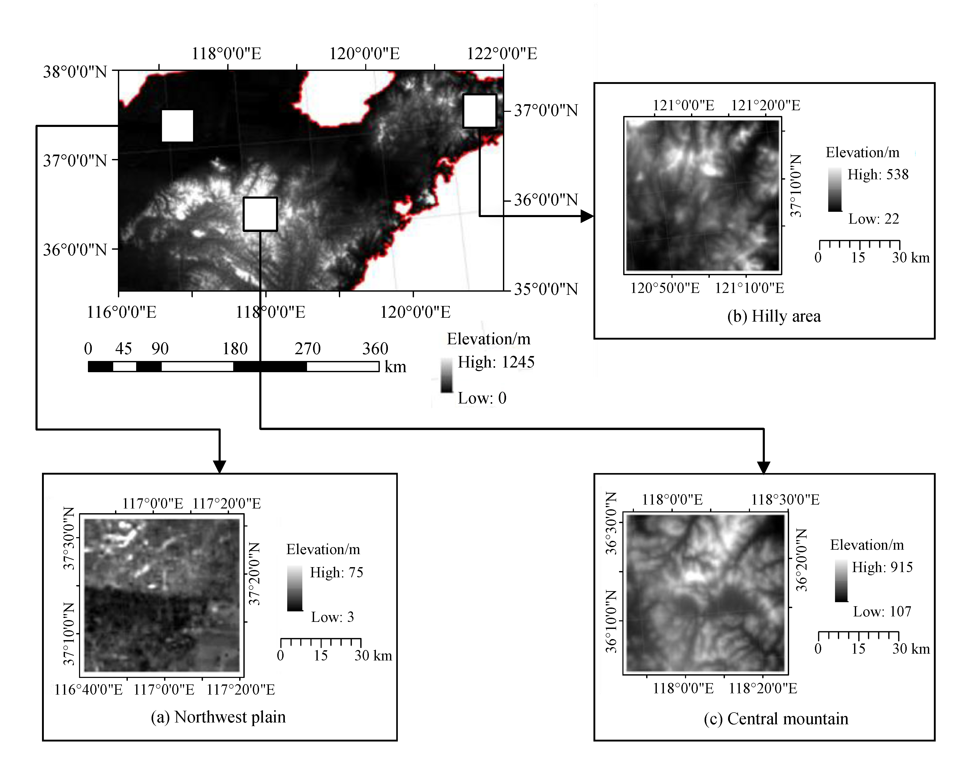
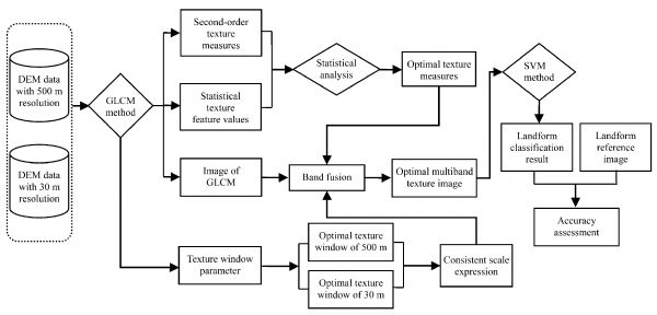
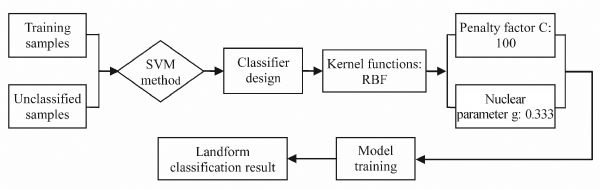
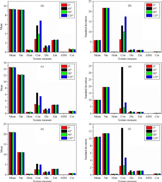
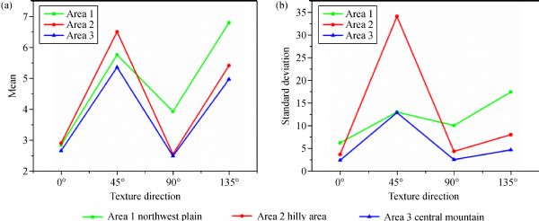
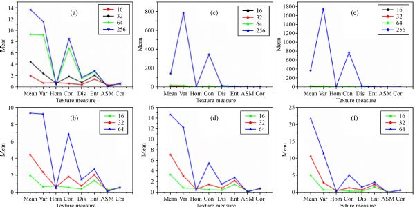
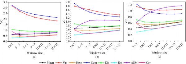
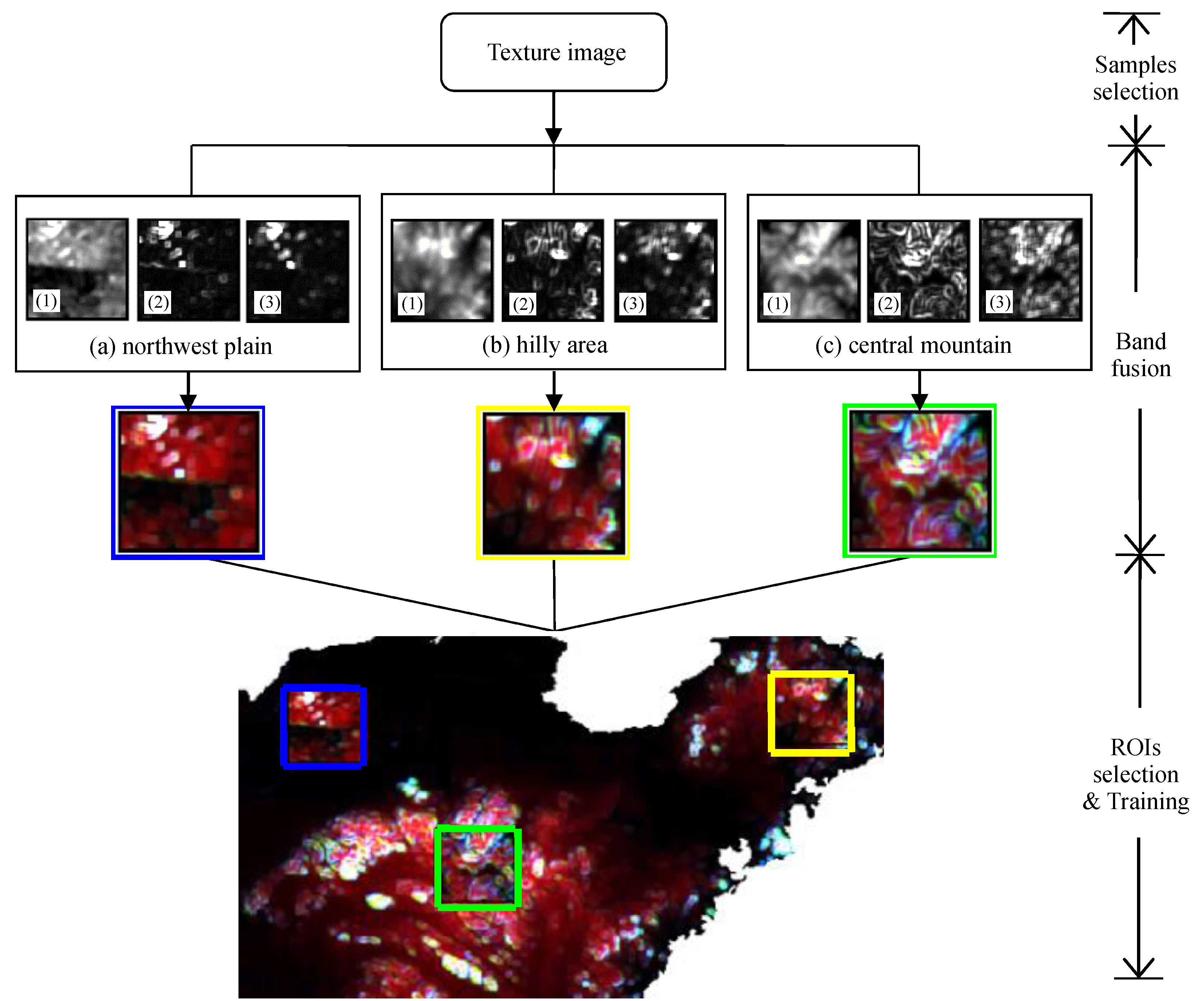
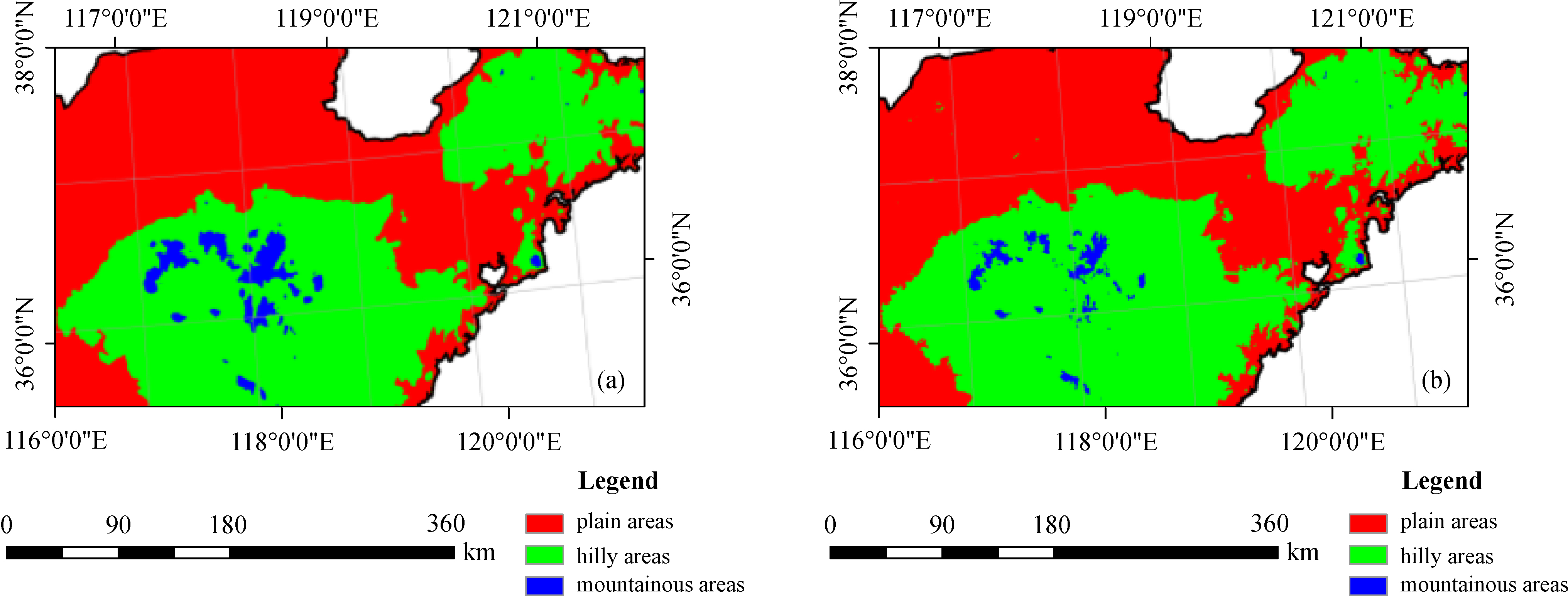
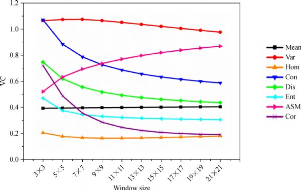
Abstract Texture and its analysis methods are crucial for image feature extraction and classification. Digital elevation model (DEM) is the most important data source of digital terrain analysis and landform classification, and considerable research values are gained from texture feature extraction and analysis from DEM data. In this research, on the basis of optimal texture feature extraction, the hilly area in Shandong, China, was selected as the study area, and DEM data with a resolution of 500 m were used as the experimental data for landform classification. First, second-order texture measures and texture image were extracted from DEM data by using a gray level co-occurrence matrix (GLCM). Second, the variation characteristics of each texture measure were analyzed, and the optimal feature parameters, such as direction, gray level, and texture window, were determined. Meanwhile, the texture feature value, combined with maximum information, was calculated, and the multiband texture image was obtained by resolving three optimal texture measure images. Finally, a support vector machine (SVM) method was adopted to classify landforms on the basis of the multiband texture image. Results indicated that the texture features of DEM data can be sufficiently represented and measured via the quantitative GLCM method. However, the feature parameters during the texture feature value calculation required further optimization. Based on the image texture from DEM data, efficient classification accuracy and ideal classification effect were achieved.
|
| Keywords
DEM data
image texture
feature extraction
Gray Level Co-occurrence Matrix (GLCM)
optimal parametric analysis
landform classification
|
|
Corresponding Author(s):
Haiying LIU
|
|
Just Accepted Date: 01 April 2019
Online First Date: 14 August 2019
Issue Date: 15 October 2019
|
|
| 1 |
M Arebey, M A Hannan, R A Begum, H Basri (2012). Solid waste bin level detection using gray level co-occurrence matrix feature extraction approach. J Environ Manage, 104: 9–18
https://doi.org/10.1016/j.jenvman.2012.03.035
|
| 2 |
J A C Ballantine, G S Okin, D E Prentiss, D A Roberts (2005). Mapping North African landforms using continental scale unmixing of MODIS imagery. Remote Sens Environ, 97(4): 470–483
https://doi.org/10.1016/j.rse.2005.04.023
|
| 3 |
T Blaschke, G J Hay, M Kelly, S Lang, P Hofmann, E Addink, R Queiroz Feitosa, F van der Meer, H van der Werff, F van Coillie, D Tiede (2014). Geographic object-based image analysis––towards a new paradigm. ISPRS J Photogramm Remote Sens, 87: 180–191
https://doi.org/10.1016/j.isprsjprs.2013.09.014
|
| 4 |
P Bugnicourt, S Guitet, V F Santos, L Blanc, E D Sotta, N Barbier, P Couteron (2018). Using textural analysis for regional landform and landscape mapping, Eastern Guiana Shield. Geomorphology, 317: 23–44
https://doi.org/10.1016/j.geomorph.2018.03.017
|
| 5 |
I Champion, C Germain, J P Da Costa, A Alborini, P Dubois-Fernandez (2014). Retrieval of forest stand age from SAR image texture for varying distance and orientation values of the gray level co-occurrence matrix. IEEE Geosci Remote Sens Lett, 11(1): 5–9
https://doi.org/10.1109/LGRS.2013.2244060
|
| 6 |
C C Chang, C J Lin (2011). LIBSVM: a library for support vector machines. ACM transactions on intelligent systems and technology (TIST), 2(3): 27
|
| 7 |
P R Chowdhury, B Deshmukh, A Goswami (2007). Machine extraction of landforms from multispectral images using texture and neural methods. Computing: Theory and Applications (ICCTA'07). International Conference on. IEEE, 2007: 721–725
|
| 8 |
H Ding, J M Na, X L Huang, G A Tang, K Liu (2018). Stability analysis unit and spatial distribution pattern of the terrain texture in the northern Shaanxi Loess Plateau. J Mt Sci, 15(3): 577–589
https://doi.org/10.1007/s11629-017-4551-4
|
| 9 |
H Ding, F Tao, W F Zhao, J M Na, G A Tang (2016). An object-based method for Chinese landform types classification. Int Arch Photogramm Remote Sens Spat Inf Sci, XLI-B7: 213–217
|
| 10 |
L Drăguţ, T Blaschke (2006). Automated classification of landform elements using object-based image analysis. Geomorphology, 81(3–4): 330–344
https://doi.org/10.1016/j.geomorph.2006.04.013
|
| 11 |
C J S Ferro, T A Warner (2002). Scale and Texture in digital image classification. Photogramm Eng Remote Sensing, 68(1): 51–64
|
| 12 |
M Hall-Beyer (2017). Practical guidelines for choosing GLCM textures to use in landscape classification tasks over a range of moderate spatial scales. Int J Remote Sens, 38(5): 1312–1338
https://doi.org/10.1080/01431161.2016.1278314
|
| 13 |
R M Haralick (1979). Statistical and structural approaches to texture. Proc IEEE, 67(5): 786–804
https://doi.org/10.1109/PROC.1979.11328
|
| 14 |
R M Haralick, K Shanmugam (1973). Textural features for image classification. IEEE Trans Syst Man Cybern, SMC-3 (6): 610–621
https://doi.org/10.1109/TSMC.1973.4309314
|
| 15 |
J K Hawkins (1970). Textural properties for pattern recognition. In: Picture Processing and Psychopictorics. New York: Academic Press, 347–370
|
| 16 |
L T K Ho, M Umitsu (2011). Micro-landform classification and flood hazard assessment of the Thu Bon alluvial plain, central Vietnam via an integrated method utilizing remotely sensed data. Appl Geogr, 31(3): 1082–1093
https://doi.org/10.1016/j.apgeog.2011.01.005
|
| 17 |
X L Huang, G A Tang, K Liu (2015). Influence of DEM resolution on the extraction of terrain texture feature. Journal of Geo-Information Science, 17(7): 822–829
|
| 18 |
A Karahaliou, S Skiadopoulos, I Boniatis, P Sakellaropoulos, E Likaki, G Panayiotakis, L Costaridou (2007). Texture analysis of tissue surrounding microcalcifications on mammograms for breast cancer diagnosis. Br J Radiol, 80(956): 648–656
https://doi.org/10.1259/bjr/30415751
|
| 19 |
T Kavzoglu, I Colkesen (2009). A kernel functions analysis for support vector machines for land cover classification. Int J Appl Earth Obs Geoinf, 11(5): 352–359
https://doi.org/10.1016/j.jag.2009.06.002
|
| 20 |
M Kim, M Madden, T A Warner (2009). Forest type mapping using object-specific texture measures from multispectral Ikonos imagery. Photogramm Eng Remote Sensing, 75(7): 819–829
https://doi.org/10.14358/PERS.75.7.819
|
| 21 |
A Lefebvre, T Corpetti (2017). Monitoring the morphological transformation of Beijing old city using remote sensing texture analysis. IEEE J Sel Top Appl Earth Obs Remote Sens, 10(2): 539–548
https://doi.org/10.1109/JSTARS.2016.2627545
|
| 22 |
K Liu, H Ding, G A Tang, A X Zhu, X Yang, S Jiang, J J Cao (2017). An object-based approach for two-level gully feature mapping using high-resolution DEM and imagery: a case study on Hilly Loess Plateau region, China. Chin Geogr Sci, 27(3): 415–430
https://doi.org/10.1007/s11769-017-0874-x
|
| 23 |
K Liu, G A Tang, Y Tao, S Jiang (2012). GLCM based quantitative analysis of terrain texture from DEMs. Journal of Geo-Information Science., 14(6): 751–760
https://doi.org/10.3724/SP.J.1047.2012.00751
|
| 24 |
G N Lv, L Y Xiong, M Chen, G A Tang, Y H Sheng, X J Liu, Z Y Song, Y Q Lu, Z Y Yu, K Zhang, M Z Wang (2017). Chinese progress in geomorphometry. J Geogr Sci, 27(11): 1389–1412
https://doi.org/10.1007/s11442-017-1442-0
|
| 25 |
F M G Martins, H M Fernandez, J M G P Isidoro, A Jordán, L Zavala (2016). Classification of landforms in Southern Portugal (Ria Formosa Basin). J Maps, 12(3): 422–430
https://doi.org/10.1080/17445647.2015.1035346
|
| 26 |
A Materka, M Strzelecki (1998). Texture analysis methods–a review. Technical University of Lodz, Institute of Electronics, COST B11 report, Brussels, 9–11
|
| 27 |
P Mohanaiah, P Sathyanarayana, L GuruKumar (2013). Image texture feature extraction using GLCM approach. Int J Sci Res Public, 3(5): 290–294
|
| 28 |
M Mokarram, G Roshan, S Negahban (2015). Landform classification using topography position index (case study: salt dome of Korsia-Darab plain, Iran). Model Earth Syst Environ, 1(4): 40-46
https://doi.org/10.1007/s40808-015-0055-9
|
| 29 |
H C Nair, A Joseph, V Padmakumari Gopinathan (2018). GIS Based landform classification using digital elevation model: a case study from two river basins of Southern Western Ghats, Kerala, India. Model Earth Syst Environ, 4(4): 1355–1363
https://doi.org/10.1007/s40808-018-0490-5
|
| 30 |
T Ota, N Mizoue, S Yoshida (2011). Influence of using texture information in remote sensed data on the accuracy of forest type classification at different levels of spatial resolution. J For Res, 16(6): 432–437
https://doi.org/10.1007/s10310-010-0233-6
|
| 31 |
Y O Ouma, J Tetuko, R Tateishi (2008). Analysis of co-occurrence and discrete wavelet transform textures for differentiation of forest and non-forest vegetation in very-high-resolution optical-sensor imagery. Int J Remote Sens, 29(12): 3417–3456
https://doi.org/10.1080/01431160701601782
|
| 32 |
A Piloyan, M Konečný (2017). Semi-automated classification of landform elements in Armenia based on SRTM DEM using k-means unsupervised classification. Quaest Geogr, 36(1): 93–103
https://doi.org/10.1515/quageo-2017-0007
|
| 33 |
O D A Prima, A Echigo, R Yokoyama, T Yoshida (2006). Supervised landform classification of Northeast Honshu from DEM-derived thematic maps. Geomorphology, 78(3‒4): 373–386
https://doi.org/10.1016/j.geomorph.2006.02.005
|
| 34 |
A Puissant, J Hirsch, C Weber (2005). The utility of texture analysis to improve per-pixel classification for high to very high spatial resolution imagery. Int J Remote Sens, 26(4): 733–745
https://doi.org/10.1080/01431160512331316838
|
| 35 |
D D G Radford, M J Cracknell, M J Roach, G V Cumming (2018). Geological mapping in Western Tasmania using radar and random forests. IEEE J Sel Top Appl Earth Obs Remote Sens, 11(9): 3075–3087
https://doi.org/10.1109/JSTARS.2018.2855207
|
| 36 |
V F Rodriguez-Galiano, M Chica-Olmo, F Abarca-Hernandez, P M Atkinson, C Jeganathan (2012). Random forest classification of mediterranean land cover using multi-seasonal imagery and multi-seasonal texture. Remote Sens Environ, 121: 93–107
https://doi.org/10.1016/j.rse.2011.12.003
|
| 37 |
P Singh, A Gupta, M Singh (2014). Hydrological inferences from watershed analysis for water resource management using remote sensing and GIS techniques. Egypt J Remote Sens Space Sci, 17(2): 111–121
https://doi.org/10.1016/j.ejrs.2014.09.003
|
| 38 |
M J Smith, C F Pain (2009). Applications of remote sensing in geomorphology. Prog Phys Geogr, 33(4): 568–582
https://doi.org/10.1177/0309133309346648
|
| 39 |
D Srivastava, B Rajitha, S Agarwal, S Singh (2018). Pattern-based image retrieval using GLCM. Neural Comput Appl, 8: 1–14
|
| 40 |
A Subasi, M Ismail Gursoy (2010). EEG signal classification using PCA, ICA, LDA and support vector machines. Expert Syst Appl, 37(12): 8659–8666
https://doi.org/10.1016/j.eswa.2010.06.065
|
| 41 |
D Tian, A L Liu, H Ding, W Zhang, W Qi (2016). Improvement of object-oriented classification method for landform types. Geography and Geo-Information Science, 32(2): 46–50
|
| 42 |
V Vapnik (1963). Pattern recognition using generalized portrait method. Autom Remote Control, 24: 774–780
|
| 43 |
V N Vapnik (1997). The Nature of Statistical Learning Theory. New York: Springer-Verlag
|
| 44 |
C Z Wang, G A Tang, S Yuan, J W Sun, K Liu (2015). A method for identifying the lunar morphology based on texture from DEMs. Journal of Geo-Information Science, 17(1): 45–53
|
| 45 |
L Y Xiong, A X Zhu, L Zhang, G A Tang (2018). Drainage basin object-based method for regional-scale landform classification: a case study of loess area in China. Phys Geogr, 39(6): 523–541
https://doi.org/10.1080/02723646.2018.1442062
|
| 46 |
Z A Zakaria, A Shabri (2012). Streamflow forecasting at ungaged sites using support vector machines. Appl Math Sci, 6(60): 3003–3014
|
| 47 |
L X Zhang, R Z Ruan, S Xia (2015). Parameter analysis of image texture of wetland in the Hongze Lake. Remote Sensing for Land and Resources, 27(1): 75–80
|
| 48 |
W F Zhao, L Y Xiong, H Ding, G A Tang (2017). Automatic recognition of loess landforms using Random Forest method. J Mt Sci, 14(5): 885–897
https://doi.org/10.1007/s11629-016-4320-9
|
| 49 |
Z B Zheng, Y Q Zhou (1997). A study of texture and description for aerial images. Acta Geodaetica et Cartographica Sinica, 26(3): 228–234
|
| 50 |
C H Zhou, W M Cheng, J K Qian, B Y Li, B P Zhang (2009). Research on the classification system of digital land geomorphology of 1:1000000 in China. Journal of Geo-Information Science, 11(6): 707–724
https://doi.org/10.3724/SP.J.1047.2009.00707
|
| 51 |
H C Zhu, W Huang, H Y Liu (2018a). Loess terrain segmentation from digital elevation models based on the region growth method. Phys Geogr, 39(1): 51–66
https://doi.org/10.1080/02723646.2017.1342215
|
| 52 |
H C Zhu, Y P Zhao, H Y Liu (2018b). Scale characters analysis for gully structure in the watersheds of loess landforms based on digital elevation models. Front Earth Sci, 12(2): 431–443
https://doi.org/10.1007/s11707-018-0696-x
|
|
Viewed |
|
|
|
Full text
|
|
|
|
|
Abstract
|
|
|
|
|
Cited |
|
|
|
|
| |
Shared |
|
|
|
|
| |
Discussed |
|
|
|
|