Suitability of common models to estimate hydrology and diffuse water pollution in North-eastern German lowland catchments with intensive agricultural land use
Muhammad WASEEM(), Frauke KACHHOLZ, Jens TRÄNCKNER
Faculty of Agriculture and Environmental Sciences, University of Rostock, 18059 Rostock, Germany
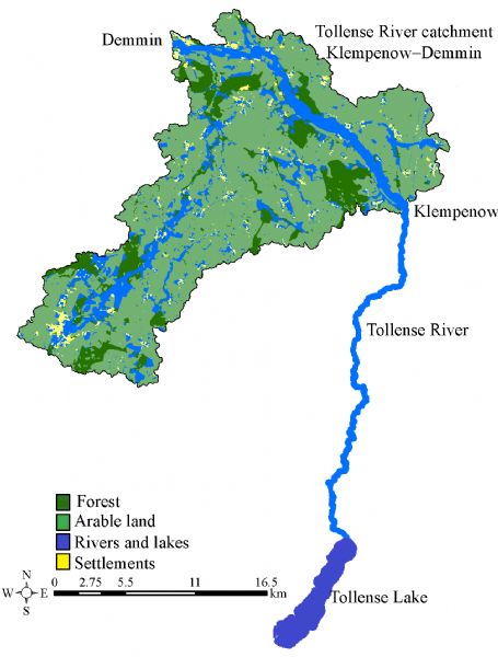
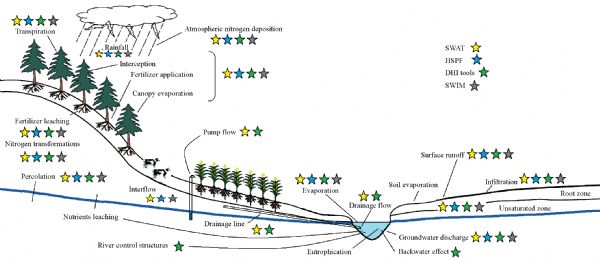
Various process-based models are extensively being used to analyze and forecast catchment hydrology and water quality. However, it is always important to select the appropriate hydrological and water quality modeling tools to predict and analyze the watershed and also consider their strengths and weaknesses. Different factors such as data availability, hydrological, hydraulic, and water quality processes and their desired level of complexity are crucial for selecting a plausible modeling tool. This review is focused on suitable model selection with a focus on desired hydrological, hydraulic and water quality processes (nitrogen fate and transport in surface, subsurface and groundwater bodies) by keeping in view the typical lowland catchments with intensive agricultural land use, higher groundwater tables, and decreased retention times due to the provision of artificial drainage. In this study, four different physically based, partially and fully distributed integrated water modeling tools, SWAT (soil and water assessment tool), SWIM (soil and water integrated model), HSPF (hydrological simulation program– FORTRAN) and a combination of tools from DHI (MIKE SHE coupled with MIKE 11 and ECO Lab), have been reviewed particularly for the Tollense River catchment located in North-eastern Germany. DHI combined tools and SWAT were more suitable for simulating the desired hydrological processes, but in the case of river hydraulics and water quality, the DHI family of tools has an edge due to their integrated coupling between MIKE SHE, MIKE 11 and ECO Lab. In case of SWAT, it needs to be coupled with another tool to model the hydraulics in the Tollense River as SWAT does not include backwater effects and provision of control structures. However, both SWAT and DHI tools are more data demanding in comparison to SWIM and HSPF. For studying nitrogen fate and transport in unsaturated, saturated, and river zone, HSPF was a better model to simulate the desired nitrogen transformation and transport processes. However, for nitrogen dynamics and transformations in shallow streams, ECO Lab had an edge due its flexibility for inclusion of user-desired water quality parameters and processes. In the case of SWIM, most of the input data and governing equations are similar to SWAT but it does not include water bodies (ponds and lakes), wetlands and drainage systems. In this review, only the processes that were needed to simulate the Tollense River catchment were considered, however the resulted model selection criteria can be generalized to other lowland catchments in Australia, North-western Europe and North America with similar complexity.
. [J]. Frontiers of Agricultural Science and Engineering, 0, (): 420-431.
Muhammad WASEEM, Frauke KACHHOLZ, Jens TRÄNCKNER. Suitability of common models to estimate hydrology and diffuse water pollution in North-eastern German lowland catchments with intensive agricultural land use. Front. Agr. Sci. Eng. , 0, (): 420-431.
MIKE SHE Spatial: flexible, Temporal: event based & continuous[38]
• Runoff on overland (2D diffusive wave equations) • Runoff in channels (1D diffusive wave equations solved by implicit fine-difference method) • Vertical flow (Richards equations) • Actual evapotranspiration[62] • Subsurface flow (3D groundwater flow equations solved using numerical finite-difference method and simulated river ground water exchange) • Chemical simulations (numerically solved advection-dispersion equation)
Tab.2
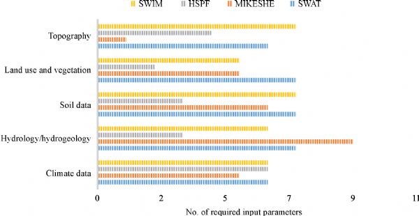
Tool
Category
Parameters
SWAT
Climate (6)
Rainfall, air temperature, solar radiation, wind speed, evapotranspiration and humidity/dew point
Hydrology and hydrogeology (7)
Water table height, hydraulic conductivity, groundwater extraction, initial shallow aquifer storage, recharge water, drain spacing, and irrigation
Soil data (7)
Layer thickness, bulk density, initial soil water content, field capacity*, wilting point*, hydraulic conductivity, and porosity
Land use and vegetation (7)
Land use, vegetation type, vegetation height, leaf area index, root depth, fertilizing rate, and crop management
Topography (6)
Area, elevation, land surface slope length, land surface slope steepness, hill slope length, and hill slope steepness
MIKE SHE
Climate (5)
Rainfall, air temperature, solar radiation, wind speed, and grass reference evaporation
Hydrology and hydrogeology (9)
Water table height, hydraulic conductivity (x-, y- and z-directions), specific yield, specific storage, groundwater extraction, initial shallow aquifer storage, recharge water, drain spacing, and irrigation
Soil data (6)
Layer thickness, bulk density, initial soil water content, field capacity, wilting point, and hydraulic conductivity
Land use and vegetation (5)
Land use, vegetation type, leaf area index, root depth, and fertilizer application rates
Topography (1)
Digital elevation model
HSPF
Climate (6)
Rainfall, air temperature, solar radiation, wind speed, evapotranspiration, and humidity/dew point
Hydrology and hydrogeology (3)
Active groundwater storage, interflow storage, and lower zone storage
Soil data (3)
Layer thickness, bulk density, and initial soil water content
Land use and vegetation (2)
Land use, and vegetation type
Topography (4)
Area, elevation, land surface slope length, land surface slope steepness
SWIM
Climate (6)
Rainfall, air temperature, solar radiation, wind speed, evapotranspiration, and humidity/dew point
Hydrology and hydrogeology (6)
Water table height, hydraulic conductivity, specific yield, groundwater extraction, drain spacing, Irrigation
Soil data (7)
Layer thickness, bulk density, initial soil water content, field capacity, wilting point, hydraulic conductivity, and porosity
Land use and vegetation (5)
Land use, vegetation type, leaf area index, root depth, and fertilizer application rates
Topography (7)
Area, elevation, land surface slope length, land surface slope steepness, hill slope length, hill slope steepness, and hill slope width
Tab.3
Item
Relevant models
SWAT
SWIM
ECO Lab*
HSPF
Initial soil nitrogen
Organic N
•
•
•
•
•
•
•
•
•
•
Point sources
Organic N
•
•
•
•
•
•
•
•
Fertilizer nitrogen (crop-specific)
Organic N
•
•
Active organic N
•
•
Inorganic N
•
•
•
•
In-stream nitrogen
Organic N
•
•
•
•
•
•
•
•
•
•
Atmospheric deposition
in rain
•
•
in rain
•
Tab.4
Fig.4
Item
Relevant models
SWAT
SWIM
ECO Lab
HSPF
Soil nitrogen
Organic N
•
•
•
•
•
•
Transport through surface runoff
in water
•
•
•
•
in water
•
•
Transport through interflow
•
•
•
•
•
•
Inorganic N
•
Transport through subsurface drainage flow
Inorganic N
•
Transport through groundwater flow
•
•
•
•
•
Transformation
Fixation
•
•
Nitrification
•
•
•
Ammonia volatilization
•
•
•
Denitrification
•
SWIM
•
•
Adsorption and desorption
Total N
•
•
Tab.5
Item
SWAT
HSPF
SWIM
DHI tools
Model type
Physically based and distributed
Physically based and distributed
Physically based and semi-distributed
Physically based and distributed
Flexibility to grid structure
Sub-basin structure but can be operated on grids
Sub-basin structure but can be operated on grids
Sub-basin structure but can be operated on grids
Flexible
Flexibility in resolution
Depends on the definition of sub-basins
Depends on the definition of sub-basin
Depends on the definition of sub-basins and hydrotopes
Flexible
Possibility of calibration
Automatic and manual
Tools available
Tools available
Automatic and manual
Tools availability
SWAT (The Soil & Water Assessment Tool) website, TAMU, USA
EPA (United States Environmental Protection Agency) website, USA
Potsdam Institute for Climate Impact Research, Potsdam, Germany
MIKE powered by DHI, Denmark
License agreement
Open source
Open
Provided on request
License required
Tab.6
1
Ziemińska-Stolarska A, Skrzypski J. Review of mathematical models of water quality. Ecological Chemistry and Engineering S, 2012, 19(2): 197–211 https://doi.org/10.2478/v10216-011-0015-x
2
Yang Y S, Wang L. A review of modeling tools for implementation of the EU water framework directive in handling diffuse water pollution. Water Resources Management, 2010, 24(9): 1819–1843 https://doi.org/10.1007/s11269-009-9526-y
3
Arhonditsis G B, Adams-Vanharn B A, Nielsen L, Stow C A, Reckhow K H. Evaluation of the current state of mechanistic aquatic biogeochemical modeling: citation analysis and future perspectives. Environmental Science & Technology, 2006, 40(21): 6547–6554 https://doi.org/10.1021/es061030q
pmid: 17144276
Melidis P, Akratos C S, Tsihrintzis V A, Trikilidou E. Characterization of rain and roof drainage water quality in Xanthi, Greece. Environmental Monitoring and Assessment, 2007, 127(1–3): 15–27 https://doi.org/10.1007/s10661-006-9254-1
pmid: 16917691
6
Naseem S, Hamza S, Bashir E. Groundwater geochemistry of Winder agricultural farms, Balochistan, Pakistan and assessment for irrigation water quality. European Water, 2010, 31: 21–32
7
Tsakiris G, Alexakis D. Water quality models: an overview. European Water, 2012, 37: 33–46
8
Carpenter S R, Caraco N F, Correll D L, Howarth R W, Sharpley A N, Smith V H. Nonpoint pollution of surface waters with phosphorus and nitrogen. Ecological Applications, 1998, 8(3): 559–568 https://doi.org/10.1890/1051-0761(1998)008[0559:NPOSWW]2.0.CO;2
9
Vörösmarty C J, McIntyre P B, Gessner M O, Dudgeon D, Prusevich A, Green P, Glidden S, Bunn S E, Sullivan C A, Liermann C R, Davies P M. Global threats to human water security and river biodiversity. Nature, 2010, 467(7315): 555–561 https://doi.org/10.1038/nature09440
pmid: 20882010
10
EEA (European Environmental Agency). European waters—assessment of status and pressures, EEA Report No. 8/2012. Copenhagen: European Environment Agency, 2012
11
Heinz I, Pulido-Velazquez M, Lund J R, Andreu J. Hydro-economic modeling in river basin management: implications and applications for the European water framework directive. Water Resources Management, 2007, 21(7): 1103–1125 https://doi.org/10.1007/s11269-006-9101-8
12
Krause S, Jacobs J, Bronstert A. Modeling the impacts of land-use and drainage density on the water balance of a lowland-floodplain landscape in northeast Germany. Ecological Modelling, 2007, 200(3–4): 475–492 https://doi.org/10.1016/j.ecolmodel.2006.08.015
13
Bøgestrand J, Kristensen P, Kronvang B. Source apportionment of nitrogen and phosphorus inputs into the aquatic environment. ResearchGate, 2005
14
Kronvang B, Behrendt H, Andersen H E, Arheimer B, Barr A, Borgvang S A, Bouraoui F, Granlund K, Grizzetti B, Groenendijk P, Schwaiger E, Hejzlar J, Hoffmann L, Johnsson H, Panagopoulos Y, Lo Porto A, Reisser H, Schoumans O, Anthony S, Silgram M, Venohr M, Larsen S E. Ensemble modelling of nutrient loads and nutrient load partitioning in 17 European catchments. Journal of Environmental Monitoring, 2009, 11(3): 572–583 https://doi.org/10.1039/b900101h
pmid: 19280035
15
Nitrate report. Joint report of the federal ministries for environment, nature conservation, construction and nuclear safety as well as for nutrition and agriculture, 2016 (in German)
16
Trepel M, Palmeri L. Quantifying nitrogen retention in surface flow wetlands for environmental planning at the landscape-scale. Ecological Engineering, 2002, 19(2): 127–140 https://doi.org/10.1016/S0925-8574(02)00038-1
17
Kieckbusch J J, Schrautzer J. Nitrogen and phosphorus dynamics of a re-wetted shallow-flooded peatland. Science of the Total Environment, 2007, 380(1–3): 3–12 https://doi.org/10.1016/j.scitotenv.2006.10.002
pmid: 17118429
18
Tiemeyer B, Lennartz B, Kahle P. Analysing nitrate losses from an artificially drained lowland catchment (North-eastern Germany) with a mixing model. Agriculture, Ecosystems & Environment, 2008, 123(1–3): 125–136 https://doi.org/10.1016/j.agee.2007.05.006
19
Krause S, Heathwaite A L, Miller F, Hulme P, Crowe A. Groundwater-dependent wetlands in the UK and Ireland: controls, functioning and assessing the likelihood of damage from human activities. Water Resources Management, 2007, 21(12): 2015–2025 https://doi.org/10.1007/s11269-007-9192-x
20
Waseem M, Koegst T, Tränckner J. Groundwater contribution to surface water contamination in a North German low land catchment with intensive agricultural land use. Journal of Water Resource and Protection, 2018, 10(3): 231–250 https://doi.org/10.4236/jwarp.2018.103014
21
Barnwell T O, Johanson R. HSPF: A comprehensive package for simulation of watershed hydrology and water quality. Nonpoint Pollution Control—Tools and Techniques for the Future, Proceedings of a Technical Symposium, 1981, 135–153
22
Munson A D. HSPF modeling of the Charles River Watershed. Dissertation for the Doctoral Degree. Boston: Massachusetts Institute of Technology, 1998
23
EPA (United States Environmental Protection Agency). Water Quality Modeling Basics and Beyond. EPA Website, available on June 24, 2018
24
Crawford N H, Linsley R K. Digital Simulation on Hydrology: Stanford Watershed Model IV. Stanford University Technical Report No. 39, 1966
25
Tzoraki O, Nikolaidis N P. A generalized framework for modeling the hydrologic and biogeochemical response of a Mediterranean temporary river basin. Journal of Hydrology, 2007, 346(3–4): 112–121 https://doi.org/10.1016/j.jhydrol.2007.08.025
26
Gallagher M, Doherty J. Parameter estimation and uncertainty analysis for a watershed model. Environmental Modelling & Software, 2007, 22(7): 1000–1020 https://doi.org/10.1016/j.envsoft.2006.06.007
27
Ribarova I, Ninov P, Cooper D. Modeling nutrient pollution during a first flood event using HSPF software: Iskar River case study, Bulgaria. Ecological Modelling, 2008, 211(1–2): 241–246 https://doi.org/10.1016/j.ecolmodel.2007.09.022
28
Srinivasan R, Ramanarayanan T S, Arnold J G, Bednarz S T. Large area hydrologic modeling and assessment part II: model application 1. Journal of the American Water Resources Association, 1998, 34(1): 91–101 https://doi.org/10.1111/j.1752-1688.1998.tb05962.x
29
Ficklin D L, Luo Y, Zhang M. Watershed modeling of hydrology and water quality in the Sacramento River watershed, California. Hydrological Processes, 2013, 27(2): 236–250 https://doi.org/10.1002/hyp.9222
30
Di Luzio M, Arnold J G, Srinivasan R. Effect of GIS data quality on small watershed stream flow and sediment simulations. Hydrological Processes, 2005, 19(3): 629–650 https://doi.org/10.1002/hyp.5612
31
Malagò A, Pagliero L, Bouraoui F, Franchini M. Comparing calibrated parameter sets of the SWAT model for the Scandinavian and Iberian peninsulas. Hydrological Sciences Journal, 2015, 60(5): 949–967 https://doi.org/10.1080/02626667.2014.978332
32
Abbaspour K C, Yang J, Maximov I, Siber R, Bogner K, Mieleitner J, Zobrist J, Srinivasan R. Modeling hydrology and water quality in the pre-alpine/alpine Thur watershed using SWAT. Journal of Hydrology, 2007, 333(2–4): 413–430 https://doi.org/10.1016/j.jhydrol.2006.09.014
33
Brown L C, Barnwell T O. The enhanced stream water quality models QUAL2E and QUAL2E-UNCAS: documentation and user manual. Athens: US Environmental Protection Agency, 1987
34
GRASS 4.1. Reference Manual. Champaign: Construction Engineering Research Laboratories, US Army Corps of Engineers, 1993
35
Krysanova V, Hattermann F, Wechsung F. Development of the ecohydrological model SWIM for regional impact studies and vulnerability assessment. Hydrological Processes, 2005, 19(3): 763–783 https://doi.org/10.1002/hyp.5619
36
Krysanova V, Wechsung F, Arnold J, Srinivasan R, Williams J. PIK Report Nr. 69, SWIM (soil and water integrated model). User Manual, 2000
37
DHI. MIKE SHE User Manual Voume 1: User Guide. Denmark: Danish Hydraulic Institute, 2007
38
Dhami B S, Pandey A. Comparative review of recently developed hydrologic models. Journal of Indian Water Resources Society, 2013, 33(3): 34–42
39
Refsgaard J C. Parameterisation, calibration and validation of distributed hydrological models. Journal of Hydrology, 1997, 198(1–4): 69–97 https://doi.org/10.1016/S0022-1694(96)03329-X
40
Butts M B, Payne J T, Kristensen M, Madsen H. An evaluation of the impact of model structure on hydrological modeling uncertainty for stream flow simulation. Journal of Hydrology, 2004, 298(1–4): 242–266 https://doi.org/10.1016/j.jhydrol.2004.03.042
41
Gao L, Li D. A review of hydrological/water-quality models. Frontiers of Agricultural Science and Engineering, 2014, 1(4): 267–276 https://doi.org/10.15302/J-FASE-2014041
Hydraulics DHI. MIKE 21 and MIKE 3 flow model hydrodynamic and transport module science documentation. Copenhagen, Denmark: DHI Water and Environment, 2009, 3–4
49
Thompson J R. Simulation of wetland water-level manipulation using coupled hydrological/hydraulic modeling. Physical Geography, 2004, 25(1): 39–67 https://doi.org/10.2747/0272-3646.25.1.39
Borah D K, Bera M. Watershed-scale hydrologic and nonpoint-source pollution models: review of mathematical bases. Transactions of the ASAE (American Society of Agricultural Engineers), 2003, 46(6): 1553 https://doi.org/10.13031/2013.15644
52
Melsen L, Teuling A, Torfs P, Zappa M, Mizukami N, Clark M, Uijlenhoet R. Representation of spatial and temporal variability in large-domain hydrological models: case study for a mesoscale pre-Alpine basin. Hydrology and Earth System Sciences, 2016, 20(6): 2207–2226 https://doi.org/10.5194/hess-20-2207-2016
53
Cho Y. Development of a watershed modeling selection program and simple equations as an alternative to complex watershed modeling. Dissertation for the Doctoral Degree. Colorado: Colorado State University, 2013
54
SloanP G, Moore I D. Modeling surface and subsurface storm flow on steeply-sloping forested watersheds. Water Resources Research, 1984, 20(12): 1815–1822
55
Duda P B, Hummel P R, Donigian A S Jr, Imhoff J C. BASINS/HSPF: model use, calibration, and validation. Transactions of the ASABE, 2012, 55(4): 1523–1547 https://doi.org/10.13031/2013.42261
56
Hattermann F, Conradt T. SWIM Soil and Water Integrated Model. Pik-potsdam website, available on June 24, 2018
57
Arnold J G, Williams J R, Srinivasan R, King K W, Griggs R H. SWAT: soil and water assessment tool. US Department of Agriculture, Agricultural Research Service, Grassland, Soil and Water Research Laboratory, Temple, TX, 494, 1994
Ritchie J T. Model for predicting evaporation from a row crop with incomplete cover. Water Resources Research, 1972, 8(5): 1204–1213 https://doi.org/10.1029/WR008i005p01204
60
Smedema L K, Rycroft D W. Land Drainage-Planning and Design of Agricultural Drainage Systems. Ithaca, New York: Cornell University Press, 1983
61
U.S. Department of Agriculture. Soil Conservation Service. Hydrology. Section 4, Chapter 19. National Engineering Handbook. USA Government Printing Office, 1983
62
Kristensen K J, Jensen S E. A model for estimating actual evapotranspiration from potential evapotranspiration. Hydrology Research, 1975, 6(3): 170–188 https://doi.org/10.2166/nh.1975.0012
63
Nasr A E, Bruen M, Jordan P, Moles R, Kiely G, Byrne P. Physically-based, distributed, catchment modelling for estimating sediment and phosphorus loads to rivers and lakes: issues of model complexity, spatial and temporal scales and data requirements. In Paper presented at the National Hydrology Seminar 2004: The Water Framework Directive-Monitoring & Modelling Issues for River Basin Management, November 2004, Tullamore, co. Offaly. Office of Public Works, 2004
64
Vanderkruk K, Owen K, Grace M, Thompson R. Review of existing nutrient, suspended solid and metal models. Scientific review for Victorian Department of Sustainability and Environment: Aquatic nutrients, suspended solids, pollutant movement and wetland ecology, 2010
65
Ward G H, Benaman J. Models for TDML application in Texas watercourses: screening and model review. Center for Research in Water Resources, University of Texas at Austin, 1999
66
Tuo Y, Chiogna G, Disse M. A multi-criteria model selection protocol for practical applications to nutrient transport at the catchment scale. Water, 2015, 7(6): 2851–2880 https://doi.org/10.3390/w7062851
67
Kauffeldt A, Wetterhall F, Pappenberger F, Salamon P, Thielen J. Technical review of large-scale hydrological models for implementation in operational flood forecasting schemes on continental level. Environmental Modelling & Software, 2016, 75: 68–76 https://doi.org/10.1016/j.envsoft.2015.09.009