Estimation of wind speeds inside Super Typhoon Nepartak from AMSR2 low-frequency brightness temperatures
Lei ZHANG1, Xiaobin YIN2(), Hanqing SHI1, Zhenzhan WANG3, Qing XU4
1. Institute of Meteorology and Oceanography, National University of Defense Technology, Nanjing 211101, China 2. Beijing Piesat Information Technology Co. Ltd, Beijing 100195, China 3. National Space Science Center, Chinese Academy of Sciences, Beijing 100190, China 4. College of Oceanography, Hohai University, Nanjing 211101, China
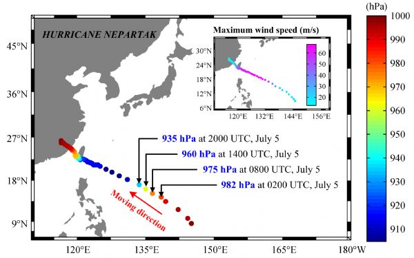
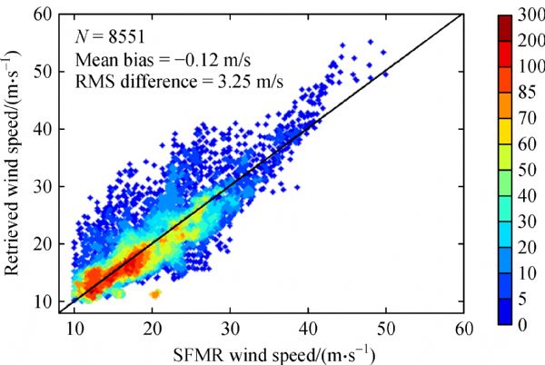
Accurate estimations of typhoon-level winds are highly desired over the western Pacific Ocean. A wind speed retrieval algorithm is used to retrieve the wind speeds within Super Typhoon Nepartak (2016) using 6.9- and 10.7-GHz brightness temperatures from the Japanese Advanced Microwave Scanning Radiometer 2 (AMSR2) sensor on board the Global Change Observation Mission-Water 1 (GCOM-W1) satellite. The results show that the retrieved wind speeds clearly represent the intensification process of Super Typhoon Nepartak. A good agreement is found between the retrieved wind speeds and the Soil Moisture Active Passive wind speed product. The mean bias is 0.51 m/s, and the root-mean-square difference is 1.93 m/s between them. The retrieved maximum wind speeds are 59.6 m/s at 04:45 UTC on July 6 and 71.3 m/s at 16:58 UTC on July 6. The two results demonstrate good agreement with the results reported by the China Meteorological Administration and the Joint Typhoon Warning Center. In addition, Feng-Yun 2G (FY-2G) satellite infrared images, Feng-Yun 3C (FY-3C) microwave atmospheric sounder data, and AMSR2 brightness temperature images are also used to describe the development and structure of Super Typhoon Nepartak.
M AGoodberlet, C TSwift, J CWilkerson (1990). Ocean surface wind speed measurements of the Special Sensor Microwave/Imager (SSM/I). IEEE Trans Geosci Remote Sens, 28(5): 823–828 https://doi.org/10.1109/36.58969
2
J YHe, S W Zhang, Z Z Wang (2015). Advanced microwave atmospheric sounder (AMAS) channel specifications and T/V calibration results on FY-3C Satellite. IEEE Trans Geosci Remote Sens, 53(1): 481–493 https://doi.org/10.1109/TGRS.2014.2324173
3
V MKrasnopolsky, L CBreaker, W HGemmill (1995). A neural network as a nonlinear transfer function model for retrieving surface wind speeds from the special sensor microwave imager. J Geophys Res Oceans, 100(C6): 11033–11045 https://doi.org/10.1029/95JC00857
4
TMeissner, L Ricciardulli, F JWentz (2016). Remote Sensing Systems SMAP daily Sea Surface Winds Speeds on 0.25 deg grid, Version 00.1 (BETA). Remote Sensing Systems, Santa Rosa, CA
5
TMeissner, F J Wentz (2009). Wind-vector retrievals under rain with passive satellite microwave radiometers. IEEE Trans Geosci Remote Sens, 47(9): 3065–3083 https://doi.org/10.1109/TGRS.2009.2027012
6
YQuilfen, C Prigent, BChapron, A AMouche, NHouti (2007). The potential of QuikSCAT and WindSat observations for the estimation of sea surface wind vector under severe weather conditions. J Geophys Res Oceans, 112: C09023 https://doi.org/10.1029/2007JC004163
7
NReul, J Tenerelli, BChapron, BChapron, DVandemark, YQuilfen, YKerr (2012). SMOS satellite L-band radiometer: a new capability for ocean surface remote sensing in hurricanes. Journal of Geophysical Research: Oceans, 117: C02006
E WUhlhorn, P G Black, J L Franklin, M Goodberlet, JCarswell, A SGoldstein (2007). Hurricane surface wind measurements from an operational stepped frequency microwave radiometer. Mon Weather Rev, 135(9): 3070–3085 https://doi.org/10.1175/MWR3454.1
12
F JWentz (1997). A well-calibrated ocean algorithm for special sensor microwave/imager. J Geophys Res Oceans, 102(C4): 8703–8718 https://doi.org/10.1029/96JC01751
13
F JWentz, T Meissner (2000). AMSR Ocean Algorithm, Algorithm Theoretical Basis Document. Remote Sensing Systems, 2000
14
B HYan, F Z Weng (2008). Applications of AMSR-E measurements for tropical cyclone predictions part I: retrieval of sea surface temperature and wind speed. Adv Atmos Sci, 25(2): 227–245 https://doi.org/10.1007/s00376-008-0227-x
15
S HYueh (2008). Directional signals in WindSat observations of hurricane ocean winds. IEEE Trans Geosci Remote Sens, 46(1): 130–136 https://doi.org/10.1109/TGRS.2007.909079
16
S HYueh, W J Wilson, S J Dinardo, S V Hsiao (2006). Polarimetric microwave wind radiometer model function and retrieval testing for WindSat. IEEE Trans Geosci Remote Sens, 44(3): 584–596 https://doi.org/10.1109/TGRS.2005.858416
17
E VZabolotskikh, L MMitnik, BChapron (2014). GCOM-W1 AMSR2 and MetOp-A ASCAT wind speeds for the extratropical cyclones over the North Atlantic. Remote Sens Environ, 147: 89–98 https://doi.org/10.1016/j.rse.2014.02.016
18
E VZabolotskikh, L MMitnik, NReul, B Chapron (2015). New possibilities for geophysical parameter retrievals opened by GCOM-W1 AMSR2. IEEE J Sel Top Appl Earth Obs Remote Sens, 8(9): 4248–4261 https://doi.org/10.1109/JSTARS.2015.2416514
19
LZhang, Z Z Wang, H Q Shi, Z Y Long, H D Du (2016a). Chaos particle swarm optimization combined with circular median filtering for geophysical parameters retrieval from WindSat. J Ocean Univ China, 15(4): 593–605 https://doi.org/10.1007/s11802-016-2859-2
20
LZhang, X Yin, HShi, Z ZWang (2016b). Hurricane wind speed estimation using WindSat 6 and 10 GHz brightness temperatures. Remote Sens, 8(9): 721 https://doi.org/10.3390/rs8090721