1. Key Laboratory of Western China’s Environmental Systems (Ministry of Education), College of Earth and Environmental Sciences, Lanzhou University, Lanzhou 730000, China 2. School of Geographic Sciences, Xinyang Normal University, Xinyang 464000, China 3. College of Tourism and Geography Science, Yunnan Normal University, Kunming 650500, China
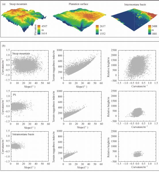
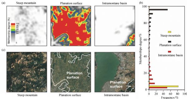
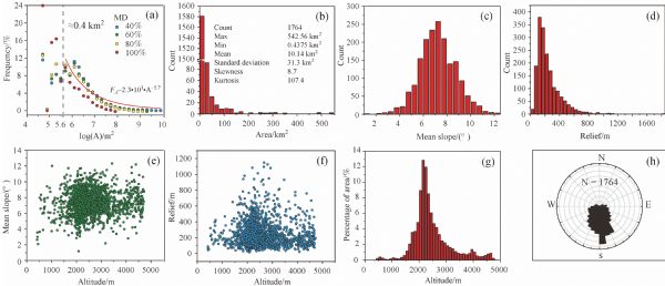
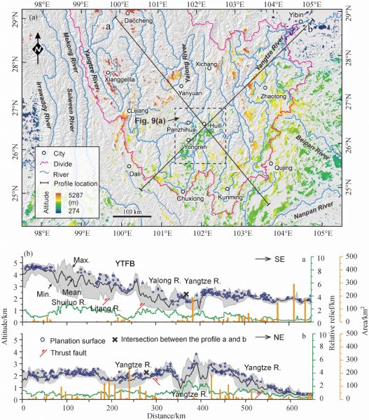
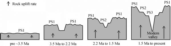
Identification of the planation surfaces (PSs) is key for utilizing them as a reference in studying the long-term geomorphological evolution of the Upper Yangtze River Basin in the Sichuan-Yunnan region, Southwest China. Using a combined method of DEM-based fuzzy logic and topographic and river profiles analysis and based on a comprehensive analysis of four morphometric parameters: slope, curvature, terrain ruggedness index, and relative height, we established the relevant fuzzy membership functions, and then calculated the membership degree (MD) of the study area. Results show that patches with a MD>80% and an area>0.4 km2 correspond well to the results of Google Earth and field investigation, representing the PS remnants. They consist of 1764 patches with an altitude, area, mean slope, and relief of mostly 2000–2500 m above sea level (asl), 0–10 km2, 4°–9°, 0–500 m, respectively, covering 9.2% of the study area’s landscape, dipping to southeast, decreasing progressively from northwest to southeast in altitude, and with no clear relation between each patch’s altitude and slope, or relief. All these results indicate that they are remnants of once regionally continuous PSs which were deformed by both the lower crust flow and the faults in upper crust, and dissected by the network of Upper Yangtze River. Additionally, topographic and river profiles analysis show that three PSs (PS1–PS3) well developed along the main valleys in the Yongren-Huili region, indicating several phases of uplift then planation during the Late Cenozoic era. Based on the incision amount deduced from projection of relict river profiles on PSs, together with erosion rates, breakup times of the PS1, PS2, and PS3 were estimated to be 3.47 Ma, 2.19 Ma, and 1.45 Ma, respectively, indicating appearance of modern Upper Yangtze River valley started between the Pliocene to early Pleistocene.
G F Adams (1975). Planation surfaces: peneplains, pediplains, and etchplains. Benchmark Paper in Geology 22. Stroudsburg PA: Dowden, Hutchington and Ross, 476
2
F Ahnert (1998). Introduction to Geomorphology. London: Amold
3
F Bascom (1921). Cycles of erosion in the Piedmont province of Pennsylvania. J Geol, 29(6): 540–559 https://doi.org/10.1086/622809
4
P Bessin, F Guillocheau, C Robin, J M Schroëtter, H Bauer (2015). Planation surfaces of the Armorican Massif (western France): denudation chronology of a Mesozoic land surface twice exhumed in response to relative crustal movements between Iberia and Eurasia. Geomorphology, 233: 75–91 https://doi.org/10.1016/j.geomorph.2014.09.026
5
P Bishop (2007). Long-term landscape evolution: linking tectonics and surface processes. Earth Surf Process Landf, 32(3): 329–365 https://doi.org/10.1002/esp.1493
6
J M Bonow (2004). Palaeosurfaces and palaeovalleys on North Atlantic previously glaciated passive margins: reference forms for conclusions on uplift and erosion. Institutionen för naturgeografi och kvartärgeologi
7
J M Bonow, P Japsen, K Lidmar-Bergström, J A Chalmers, A K Pedersen (2006a). Cenozoic uplift of Nuussuaq and Disko, West Greenland—Elevated erosion surfaces as uplift markers of a passive margin. Geomorphology, 80(3–4): 325–337 https://doi.org/10.1016/j.geomorph.2006.03.006
8
J M Bonow, P Japsen, T F Nielsen (2014). High-level landscapes along the margin of southern East Greenland—A record of tectonic uplift and incision after breakup in the NE Atlantic. Global Planet Change, 116(2): 10–29 https://doi.org/10.1016/j.gloplacha.2014.01.010
9
J M Bonow, K Lidmar-Bergström, P Japsen (2006b). Palaeosurfaces in central West Greenland as reference for identification of tectonic movements and estimation of erosion. Global Planet Change, 50(3–4): 161–183 https://doi.org/10.1016/j.gloplacha.2005.12.011
10
G V Bosch, J Van Den Driessche, J Babault, A Robert, A Carballo, C, Le Carlier N Loget, C Prognon, R Wyns, T Baudin (2016). Peneplanation and lithosphere dynamics in the Pyrenees. C R Geosci, 348: 194–202 https://doi.org/10.1016/j.crte.2015.08.005
11
P A Burrough, R A McDonell (1998). Principles of geographical information systems. New York: Oxford University Press, 190
12
M Calvet, Y Gunnell, B Farines (2015). Flat-topped mountain ranges: their global distribution and value for understanding the evolution of mountain topography. Geomorphology, 241: 255–291 https://doi.org/10.1016/j.geomorph.2015.04.015
13
F B Chen (1992). Hengduan event: an important tectonic event of the Late Cenozoic in Eastern Asian. Mountain Research, 10(1): 195– 202
14
M K Clark, M A House, L H Royden, K X Whipple, B C Burchfiel, X Zhang, W Tang (2005). Late Cenozoic uplift of southeastern Tibet. Geology, 33(6): 525–528 https://doi.org/10.1130/G21265.1
15
M K Clark, L H Royden (2000). Topographic ooze: building the eastern margin of Tibet by lower crustal flow. Geology, 28(8): 703–706 https://doi.org/10.1130/0091-7613
16
M K Clark, L H Royden, K X Whipple, B C Burchfiel, X Zhang, W Tang (2006). Use of a regional, relict landscape to measure vertical deformation of the eastern Tibetan Plateau. J Geophys Res, 111(F3): F03002 https://doi.org/10.1029/2005JF000294
17
M K Clark, L M Schoenbohm, L H Royden, K X Whipple, B C Burchfiel, X Zhang, W Tang, E Wang, L Chen (2004). Surface uplift, tectonics, and erosion of eastern Tibet from large-scale drainage patterns. Tectonics, 23(1): TC1006 https://doi.org/10.1029/2002TC001402
18
P D Clift, Z Sun (2006). The sedimentary and tectonic evolution of the Yinggehai – Song Hong basin and the southern Hainan margin, South China Sea: implications for Tibetan uplift and monsoon intensification. J Geophys Res, 111(B6): B06405 https://doi.org/10.1029/2005JB004048
19
M Coltorti, D Firuzabadi, A Borri, P Fantozzi, P Pieruccini (2015). Planation surfaces and the long-term geomorphological evolution of Ethiopia. In: Billi P, eds. Landscapes and Landforms of Ethiopia. Springer Netherlands, 51(6): 117–136 https://doi.org/10.1007/978-94-017-8026-1_5
20
Z J Cui, D W Li, J L Feng, G N Liu, H J Li (2001a). Covered karst, weathering crust and karst planation surface. Sci China Earth Sci, 31(6): 510–520
21
Z J Cui, D W Li, G N Liu, J L Feng, W Zhang (2001b). The properties of the lateritic karst weathering crust and the formation environment of planation surfaces in Tibet, Yunnan, Guizhou, and Hunan province. Sci China Earth Sci, 31: 134–141
22
W M Davis (1889a). The rivers and valleys of Pennsylvania. National Geographic Society, 1: 183–253
23
W M Davis (1889b). Topographic development of the Triassic formation of the Connecticut Valley. American Journal of Science, 3rd Ser., 37: 423–434 https://doi.org/10.2475/ajs.s3-37.222.423
J L Feng, Z J Cui, W Zhang, D W Li, G N Liu, L P Zhu (2004). Genesis of the layered landform surfaces in Dongchuan, Yunan Province. J Mt Sci, 22(2): 165–174
26
J J Flint (1974). Stream gradient as a function of order, magnitude, and discharge. Water Resour Res, 10(5): 969–973 https://doi.org/10.1029/WR010i005p00969
27
M A Foster, H M Kelsey (2012). Knickpoint and knickzone formation and propagation, South Fork Eel River, northern California. Geosphere, 8(2): 403–416 https://doi.org/10.1130/GES00700.1
28
F Guillocheau, B Simon, G Baby, P Bessin, C Robin, O Dauteuil (2018). Planation surfaces as a record of mantle dynamics: the case example of Africa. Gondwana Res, 53(1): 82–98 https://doi.org/10.1016/j.gr.2017.05.015
29
J T Hack (1973). Stream-profile analysis and stream-gradient index. J Res US Geol Surv, 1(4): 421–429
30
V L Haider, I Dunkl, H V Eynatten, L Ding, D Frei, L Y Zhang (2013). Cretaceous to Cenozoic evolution of the northern Lhasa Terrane and the Early Paleogene development of peneplains at Nam Co, Tibetan Plateau. J Asian Earth Sci, 70–71(1): 79–98 https://doi.org/10.1016/j.jseaes.2013.03.005
31
V L Haider, J Kropáček, I Dunkl, B Wagner, von H Eynatten (2015). Identification of peneplains by multi-parameter assessment of digital elevation models. Earth Surf Process Landf, 40(11): 1477–1492 https://doi.org/10.1002/esp.3729
32
N Harkins, E Kirby, A Heimsath, R Robinson, U Reiser (2007). Transient fluvial incision in the headwaters of the Yellow River, northeastern Tibet, China. J Geophys Res Earth Surf, 112(F3), https://doi.org/10.1029/2006JF000570 https://doi.org/10.1029/2006JF000570
33
Z He, X Zhang, S Bao, Y S Qian, Y Y Sheng, X T Liu, X L He, X C Yang, J X Zhao, R Liu, C Y Lu (2015). Multiple climatic cycles imprinted on regional uplift-controlled fluvial terraces in the lower Yalong River and Anning River, SE Tibetan Plateau. Geomorphology, 250: 95–112 https://doi.org/10.1016/j.geomorph.2015.08.010
34
R Hetzel, I Dunkl, V Haider, M Strobl, Eynatten H Von, L Ding, D Frei (2011). Peneplain formation in southern Tibet predates the India-Asia collision and plateau uplift. Geology, 39(10): 983–986 https://doi.org/10.1130/G32069.1
35
M H Huang (1992). Research on the stratified landform in the Southwest of China. Journal of Suzhou Railway Teachers College, 9(4): 57–63 (in Chinese)
36
R J Huggett (2016). Fundamentals of Geomorphology. London: Routledge, 436
37
P Japsen, J M Bonow, P F Green, J A Chalmers, K Lidmar-Bergström (2009). Formation, uplift and dissection of planation surfaces at passive continental margins—A new approach. Earth Surf Process Landf, 34(5): 683–699 https://doi.org/10.1002/esp.1766
38
A Jarvis, H I Reuter, A Nelson, E Guevara (2008). Hole-filled SRTM for the globe Version 4. CGIAR-CSI SRTM 90m Database.
M Jolivet, J F Ritz, R Vassallo, C Larroque, R Braucher, M Todbileg, A Chauvet, C Sue, N Arnaud, R de Vicente A Arzhanikova, S Arzhanikov (2007). Mongolian summits: an uplifted, flat, old but still preserved erosion surface. Geology, 35(10): 871–874 https://doi.org/10.1130/G23758A.1
41
L Kennan, S Lamb, L Hoke (1997). High-altitude palaeosurfaces in the Bolivian Andes: evidence for late Cenozoic surface uplift. Geol Soc Lond Spec Publ, 120(1): 307–323 https://doi.org/10.1144/GSL.SP.1997.120.01.20
42
L C King (1962). Morphology of the Earth. Edinburgh: Oliver and Boyd
43
E Kirby, C Regalla, W B Ouimet, P R Bierman (2010). Reconstructing temporal variation in fault slip from footwall topography: an example from Saline valley, California, 2010 Fall Meeting, American Geophysical Union, San Francisco, CA
A Kühni, O A Pfiffner (2001). The relief of the Swiss Alps and adjacent areas and its relation to lithology and structure: topographic analysis from a 250-m DEM. Geomorphology, 41(4): 285–307 https://doi.org/10.1016/S0169-555X(01)00060-5
C Lei, J Y Ren, P Sternai, M Fox, S Willett, X N Xie, P D Clift, J H Liao, Z F Wang (2015). Structure and sediment budget of Yinggehai–Song Hong basin, South China Sea: implications for Cenozoic tectonics and river basin reorganization in Southeast Asia. Tectonophysics, 655: 177–190 https://doi.org/10.1016/j.tecto.2015.05.024
48
C Li, X Jiang, W Gong, D Li, C Li (2018). Surface uplift of the Central Yunnan Plateau since the Pliocene. Geol J, 53: 386–396 https://doi.org/10.1002/gj.2904
49
H Li, X Y Huang, Q L Deng, T M Kusky, X B Cai (2012). Mapping of planation surfaces in the southwest region of Hubei Province, China—Using the DEM-derived painted relief model. J Earth Sci, 23(5): 719–730 https://doi.org/10.1007/s12583-012-0290-1
50
J J Li (1999). In memory of Davisian theory of erosion cycle and peneplain: a centurial study in China. Journal of Lanzhou University (Natural Sciences), 35(3): 157–163
51
J J Li, Y F Shi, B Y Li (1995). Uplift of the Qinghai-Xizang (Tibet) Plateau and global change. Lanzhou University Press, 1451–1452
52
J J Li, S Y Xie, M S Kuang (2001). Geomorphic evolution of the Yangtze Gorges and the time of their formation. Geomorphology, 41(2–3): 125–135 https://doi.org/10.1016/S0169-555X(01)00110-6
53
K Lidmar-Bergström, J M Bonow, P Japsen (2013). Stratigraphic landscape analysis and geomorphological paradigms: Scandinavia as an example of Phanerozoic uplift and subsidence. Global Planet Change, 100: 153–171 https://doi.org/10.1016/j.gloplacha.2012.10.015
54
J Liu-Zeng, P Tapponnier, Y Gaudemer, L Ding (2008). Quantifying landscape differences across the Tibetan plateau: implications for topographic relief evolution. J Geophys Res Earth Surf, 113(F04018): 1–26 https://doi.org/10.1029/2007JF000897
55
Z H Ma, X M Li, B H Guo, H Yu, X Y Ye, C H Song, J J Li (2016). Extraction and analysis of Maxianshan planation surfaces in northeastern margin of the Tibetan Plateau. Acta Geogr Sin, 71(3): 400–411
56
S R Miller, P B Sak, E Kirby, P R Bierman (2013). Neogene rejuvenation of central Appalachian topography: evidence for differential rock uplift from stream profiles and erosion rates. Earth Planet Sci Lett, 369–370: 1–12 https://doi.org/10.1016/j.epsl.2013.04.007
57
F J Monkhouse, H R Wilkinson (1952). Population Maps and Diagrams. Maps and Diagrams, Methuen, London
58
J D Niemann, N M Gasparini, G E Tucker, R L Bras (2001). A quantitative evaluation of Playfair’s law and its use in testing long-term stream erosion models. Earth Surf Process Landf, 26(12): 1317–1332 https://doi.org/10.1002/esp.272
B T Pan, Z B Hu, J P Wang, J Vandenberghe, X F Hu, Y H Wen, Q Li, B Cao (2012). The approximate age of the planation surface and the incision of the Yellow River. Palaeogeography, Palaeoclimatology, Palaeoecology, 356: 54–61 https://doi.org/10.1016/j.palaeo.2010.04.011
61
S D Peckham, T Hengl, J Evans, J P Wilson, M Gould (2011). Profile, plan and streamline curvature: a simple derivation and applications. In: Proceedings of the International Society for Geomorphometry, Redlands, CA. 27–30
Y Qian, L Xiong, J Li, G Tang (2016). Landform planation index extracted from DEMs: a case study in Ordos Platform of China. Chin Geogr Sci, 26(3): 314–324 https://doi.org/10.1007/s11769-016-0811-4
64
H I Reuter, A Nelson, A Jarvis (2007). An evaluation of void-filling interpolation methods for SRTM data. Int J Geogr Inf Sci, 21(9): 983–1008 https://doi.org/10.1080/13658810601169899
65
R Rigon, A Rinaldo, I Rodriguez-Iturbe (1994). On landscape self-organization. J Geophys Res, 99(11): 911–971 https://doi.org/10.1029/93JB03601
66
S J Riley, S D DeGloria, R Elliot (1999). A terrain ruggedness index that quantifies topographic heterogeneity. Intermt J Sci, 5(1–4): 23–27
67
P S Ringrose, P Migon (1997). Analysis of digital elevation data for the Scottish Highlands and recognition of pre-Quaternary elevated surfaces. Geol Soc Lond Spec Publ, 120(1): 25–35 https://doi.org/10.1144/GSL.SP.1997.120.01.03
68
M D Rowberry (2012). A comparison of three terrain parameters that may be used to identify denudation surfaces within a GIS: a case study from Wales, United Kingdom. Comput Geosci, 43: 147–158 https://doi.org/10.1016/j.cageo.2011.09.016
69
M D Rowberry, P A Brewer, M G Macklin (2007). The number, form and origin of sub-horizontal surfaces in north Ceredigion, Wales UK. Norwegian Journal of Geology/Norsk Geologisk Forening, 87(1–2): 207–222
70
L H Royden, B C Burchfiel, R W King, E Wang, Z Chen, F Shen, Y Liu (1997). Surface deformation and lower crustal flow in Eastern Tibet. Science, 276(5313): 788–790 https://doi.org/10.1126/science.276.5313.788
71
L M Schoenbohm, K X Whipple, B C Burchfiel, L Chen (2004). Geomorphic constraints on surface uplift, exhumation, and plateau growth in the Red River region, Yunnan Province, China. Geol Soc Am Bull, 116(7): 895–909 https://doi.org/10.1130/B25364.1
R Shackleton, C Chang (1988). Cenozoic uplift and deformation of the Tibetan Plateau: the geomorphological evidence. Philosophical Transactions of the Royal Society A, 327(1594): 365–377 https://doi.org/10.1098/rsta.1988.0134
74
J Shen, S M Wang, Y Wang, X K Qiang, H F Xiao, X Y Xiao (2010). Uplift events of the Qinghai–Tibetan Plateau and environmental evolution of the southwest monsoon since 2.7 Ma, recorded in a long lake sediment core from Heqing, China. Quat Int, 218(1–2): 67–73 https://doi.org/10.1016/j.quaint.2009.11.039
75
M Strobl, R Hetzel, L Ding, L Zhang, A Hampel (2010). Preservation of a large-scale bedrock peneplain suggests long-term landscape stability in southern Tibet. Z Geomorphol, 54(4): 453–466 https://doi.org/10.1127/0372-8854/2010/0054-0023
76
H Su, Q Z Ming, B T Pan, H S Gao, W X Zhang, M Dong, Z T Shi (2013). The analysis and discussions on the chronological frame of Jinshajiang River valley-drainage. J Mt Sci, 31(6): 685–692
77
P Van der Beek, van J Melle, S Guillot, A Pêcher, P W Reiners, S Nicolescu, M Latif (2009). Eocene Tibetan Plateau remnants preserved in the northwest Himalaya. Nat Geosci, 2(5): 364–368 https://doi.org/10.1038/ngeo503
J Vandenberghe (2016). From planation surfaces to river valleys. BSGLg, 67: 93–106
80
M Veselský, P Bandura, L Burian, T Harciníková, P Bella (2015). Semi-automated recognition of planation surfaces and other flat landforms: a case study from the Aggtelek Karst, Hungary. Open Geosciences, 7(1): 799–811 https://doi.org/10.1515/geo-2015-0063
81
E Wang, B C Burchfiel (2000). Late Cenozoic to Holocene deformation in southwestern Sichuan and adjacent Yunnan, China, and its role in formation of the southeastern part of the Tibetan Plateau. Geol Soc Am Bull, 112(3): 413–423 https://doi.org/10.1130/0016-7606(2000)112 <413:LCTHDI>2.0.CO;2
82
E Wang, B C Burchfiel, L H Royden, L Chen, J Chen, W Li, Z Chen (1998). Late Cenozoic Xianshuihe-Xiaojiang, Red River, and Dali fault systems of southwestern Sichuan and central Yunnan, China. Spec Pap Geol Soc Am, 327: 1–108 https://doi.org/10.1130/0-8137-2327-2.1
83
X Wang, H Lu, J Vandenberghe, S Zheng, Balen R van (2012). Late Miocene uplift of the NE Tibetan Plateau inferred from basin filling, planation and fluvial terraces in the Huang Shui catchment. Global Planet Change, 88– 89: 10–19 https://doi.org/10.1016/j.gloplacha.2012.02.009
84
Y Wang, B Pan, H Gao, Y Liu (2005). Planation surface extraction and quantitative analysis based on high-resolution digital elevation models. International Geoscience and Remote Sensing Symposium, 8: 5369–5371 https://doi.org/10.1109/IGARSS.2005.1525952
85
K X Whipple, R A Dibiase, W B Ouimet, A M Forte (2017). Preservation or piracy: diagnosing low-relief, high-elevation surface formation mechanisms. Geology, 45(1): 91–94 https://doi.org/10.1130/G38490.1
C W Wobus, B T Crosby, K X Whipple (2006). Hanging valleys in fluvial systems: controls on occurrence and implications for landscape evolution. J Geophys Res, 111(F2): F02017 https://doi.org/10.1029/2005JF000406
88
M Xie (1990). Neotectonic uplift velocity and type along the Changjiang River during Quaternary. Quaternary Sciences, 4: 308–315 (in Chinese)
89
L Y Xiong, G A Tang, A X Zhu, Y Q Qian (2017). A peak-cluster assessment method for the identification of upland planation surfaces. Int J Geogr Inf Sci, 31(2): 387–404 https://doi.org/10.1080/13658816.2016.1205193
90
R Yang, S D Willett, L Goren (2015). In situ low-relief landscape formation as a result of river network disruption. Nature, 520(7548): 526–529 https://doi.org/10.1038/nature14354
M Zárate, A Folguera (2014). Planation surfaces of Central Western Argentina. In: Rabassa J, Ollier C, eds. Gondwana Landscapes in Southern South America. Springer Netherlands, 365–392
93
L W Zevenbergen, C R Thorne (1987). Quantitative analysis of land surface topography. Earth Surf Process Landf, 12(1): 47–56 https://doi.org/10.1002/esp.3290120107
Y C Zhang, J J Li, J J Zhu, M S Kuang, Y Chen (1999). Studies on development of Yuanmou basin and valleys during Late Cenozoic. Journal of Lanzhou University (Natural Sciences), 35(1): 199–205
96
H Zheng, P D Clift, P Wang, R Tada, J Jia, M He, F Jourdan (2013). Pre-Miocene birth of the Yangtze River. Proc Natl Acad Sci USA, 110(19): 7556–7561 https://doi.org/10.1073/pnas.1216241110
97
S Zhou, L Xu, J Cui, X Zhang, J Zhao (2005). Geomorphologic evolution and environmental changes in the Shaluli Mountain region during the Quaternary. Chin Sci Bull, 50(1): 52–57 https://doi.org/10.1360/03wd0248
98
R X Zhu, R Potts, Y X Pan, L Q Lü, H T Yao, C L Deng, H F Qin (2008). Paleomagnetism of the Yuanmou Basin near the southeastern margin of the Tibetan Plateau and its constraints on late Neogene sedimentation and tectonic rotation. Earth Planet Sci Lett, 272(1–2): 97–104 https://doi.org/10.1016/j.epsl.2008.04.016