|
|
|
Sandwaves on the Southeast Vietnam Shelf recorded by high resolution seismic profiles: formation and mechanism |
Viet Dung BUI1,2( ), Schimanski ALEX2, Stattegger KARL2, Van Phach PHUNG1, The Tiep NGUYEN1, Tien Hai NGUYEN1, Trung Thanh NGUYEN1, Truong Thanh PHI1 ), Schimanski ALEX2, Stattegger KARL2, Van Phach PHUNG1, The Tiep NGUYEN1, Tien Hai NGUYEN1, Trung Thanh NGUYEN1, Truong Thanh PHI1 |
| 1. Institute for Marine Geology and Geophysics, 18 Hoang Quoc viet, Hanoi, Vietnam; 2. Institutes of Geosciences, Kiel University, D-24118, Kiel, Germany |
|
|
|
|
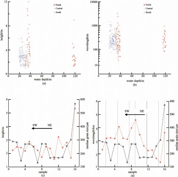
Abstract The application of high resolution seismic data using boomer sound source has revealed a wide distribution of large-scale bedforms (sandwaves) on the Southeast Vietnam continental shelf. Bedforms that are a few meters high in wave height and hundreds of meters long in wavelength are primarily developed in the inner shelf (20-40 m) and considered to be formed under the present-day marine hydrodynamic conditions. Those bedforms developed in the deeper water (120 m) of the northernmost part of the continent can be interpreted as the relict morphological features formed during the latest sea-level lowstand of the late Pleistocene period. Two sediment transport paths have been identified on the basis of the bedform’s leeward orientation: northeast-southwest (along-shore) and north-south (cross-shore). A quantitative bottom current map is constructed from sandwave dimensions, surface sediments and measurement data. The strongest current velocities that gradually decrease toward the southwest are indicated by large sandwaves in the north (field B). Water depth, surficial sediment composition and bottom current are three factors that control the development of bedforms.
|
| Keywords
bedforms
sandwaves
bottom currents
Southeast Vietnam Shelf
|
|
Corresponding Author(s):
BUI Viet Dung,Email:buivietdungspt@yahoo.com
|
|
Issue Date: 05 March 2009
|
|
| 1 |
Aliotta S, Perillo G M E (1987). A sandwave field in the entrance to Bahia Blanca Estuary. Argentina Mar Geol , 76: 1-14
doi: 10.1016/0025-3227(87)90013-2
|
| 2 |
Allen J R L(1972). Instability of an upper-phase plane bed: a test of Bagnold’s criterion. Sediment Geol , 8:309-316
doi: 10.1016/0037-0738(72)90046-2
|
| 3 |
Allen P A, Homewood P (1984). Evolution and mechanics of a Miocene tidal sandwave. Sedimentology , 31:63-81
doi: 10.1111/j.1365-3091.1984.tb00723.x
|
| 4 |
Ashley G M (1990). Classification of large-scale subaqueous bedforms: a new look at an old problem. J Sedim Petrol , 60 (1): 160-172
|
| 5 |
Dalrymple R D, Knight R J, Lambiase J J (1978). Bedforms and their hydraulic stability relationships in a tidal environment, Bay of Fundy, Canada. Nature 275, 100-104
doi: 10.1038/275100a0
|
| 6 |
Dyer K R (1986). Coastal and Estuary Sediment Dynamics. Chichester: John Willey & Sons , 342
|
| 7 |
Fenster M S (1990). Stability of giant sandwaves in eastern Long Island Sound, USA. Mar Geol , 91: 207-225
doi: 10.1016/0025-3227(90)90037-K
|
| 8 |
Flemming B W (1978). Underwater sand dunes along the southeast African continental margin: observations and implications. Mar Geol , 26: 177-198
|
| 9 |
Flemming B W (1988). Zur klassification subaquatischer, str?mungstransversaler transportk?rper. Bochumer Geol U Geotechn Arb Bochum , 29: 44-47
doi: 10.1016/0025-3227(78)90059-2
|
| 10 |
Hanebuth T J J, Stattegger K, Grootes P M (2000). Rapid flooding of the Sunda Shelf; A Late-Glacial Sea-Level record. Science , 288:1033-1035
doi: 10.1126/science.288.5468.1033
|
| 11 |
Hanebuth T J J, Stattegger K, Saito Y (2002). The stratigraphic architecture of the central Sunda Shelf (SE Asia) recorded by shallow-seismic surveying. Geo-Marine Letters , 22:86-94
doi: 10.1007/s00367-002-0102-1
|
| 12 |
Harris P T, Collins M B (1984). Side-scan sonar investigation into temporal variation in sandwave morphology: Helwick Sands, Bristol Channel. Geo-Mar Lett , 4: 91-97
doi: 10.1007/BF02277078
|
| 13 |
Harris P T (1988). Large-scale bedforms as indicators of mutually evasive sand transport and the sequential infilling of wide-mouthed estuaries. Sedim Geol , 57: 273-298
doi: 10.1016/0037-0738(88)90034-6
|
| 14 |
Kuijpers A, 1985. Current-induced bedforms in the Danish Straits between Kattegat and Baltic Sea. Meyniana , 37, 97-127
|
| 15 |
Langhorne, D.N (1982). A study of the dynamics of a marine sand wave. Spec Publ Int Assoc Sedimentol , 6, 571-594
|
| 16 |
Lanh VV, Hoan DV (2002). The Southward cold current along the coast of central Vietnam. Collection of Marine Research Works , XII: 19-32
|
| 17 |
Lanh V V, Phung P (1990). Hydrographic structure and hydrodynamic of the East Vietnam Sea and adjacent areas. In:The average seasonal flow current . Part A, Chapter 4, National project 48B. Nha Trang
|
| 18 |
Long B H, Sam T, Vinh N K (1981). Study the physical hydrography charecteristics of the Thuan Hai-Minh Hai sea, The general investigation of Thuan Hai-Minh Hai coastal zone. Nha Trang
|
| 19 |
McCave I N (1971). Sandwaves in the North Sea off the coast of Holland. Mar Geol , 10: 199-225
doi: 10.1016/0025-3227(71)90063-6
|
| 20 |
Nguyen V L, Ta T K O, Tateishi M (2000). Late Holocene depositional environments and coastal evolution of the Mekong River Delta, Southern Vietnam. Journal of Asian Earth Sciences , 18(4):427-439
doi: 10.1016/S1367-9120(99)00076-0
|
| 21 |
Ninh P V (Ed.) (2003). South China Sea Monograph. Vol II –Meteorology, Marine Hydrology and Hydrodynamics , Hanoi National University Publisher, Hanoi, 565 (in Vietnamese)
|
| 22 |
Que B C (Ed) (2005). Reconstruct map of natural and environment characteristics of Vietnam sea and adjacent areas. National research project KC 09-02
|
| 23 |
Schimanski A, Stattegger K (2005). Deglacial and Holocene Evolution of the Vietnam Shelf: Stratigraphy, Sediments and Sea-level change. Mar Geol , 214: 365-387
doi: 10.1016/j.margeo.2004.11.001
|
| 24 |
Stride A H (1982). Offshore Tidal Sands. London: Chapman & Hall, 222
|
| 25 |
Ta T K O, Nguyen V L, Tateishi M, Kobayashi I, Saito Y (2001). Sedimentary facies, diatom and foraminifer assemblages in a late Pleistocene-Holocene incised-valley sequence from the Mekong River delta, Bentre Province, southern Vietnam; the BT2 core. Journal of Asian Earth Sciences , 20(1): 83-94
doi: 10.1016/S1367-9120(01)00028-1
|
| 26 |
Ta T K O, Van Lap Nguyen, Masaaki Tateishi, Iwao Kobayashi, Susumu Tanabe, Yoshiki Saito (2002). Holocene delta evolution and sediment discharge of the Mekong River, southern Vietnam. Quaternary Science Reviews ,β21(16-17), 1807-1819
doi: 10.1016/S0277-3791(02)00007-0
|
| 27 |
Wolanski E, Nguyen N H, Le T D, Nguyen H N, Nguyen N T (1996). Fine-sediment Dynamics in the Mekong River Estuary, Vietnam. Estuarine Coastal and Shelf Science , 43: 565-582
doi: 10.1006/ecss.1996.0088
|
| 28 |
Wooding R A, Bradley E F, Marshall J K (1973). Drag due to regular arrays of roughness elements of varying geometry. Boundary Layer Meteorol , 5: 285-308
doi: 10.1007/BF00155238
|
| 29 |
Wyrtky K (1961). Physical oceanography of the South Asian waters. Scientific results of marine investigations of the South China Sea and the Gulf of Thailand. NAGA Report.Scripps Institute of Oceanography, CA , 1-115
|
|
Viewed |
|
|
|
Full text
|
|
|
|
|
Abstract
|
|
|
|
|
Cited |
|
|
|
|
| |
Shared |
|
|
|
|
| |
Discussed |
|
|
|
|