|
|
|
Three distinct global estimates of historical land-cover change and land-use conversions for over 200 years |
Prasanth MEIYAPPAN, Atul K. JAIN( ) ) |
| Department of Atmospheric Sciences, University of Illinois, Urbana, IL 61801, USA |
|
|
|
|
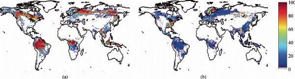
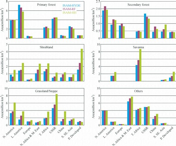
Abstract Earth’s land cover has been extensively transformed over time due to both human activities and natural causes. Previous global studies have focused on developing spatial and temporal patterns of dominant human land-use activities (e.g., cropland, pastureland, urban land, wood harvest). Process-based modeling studies adopt different strategies to estimate the changes in land cover by using these land-use data sets in combination with a potential vegetation map, and subsequently use this information for impact assessments. However, due to unaccounted changes in land cover (resulting from both indirect anthropogenic and natural causes), heterogeneity in land-use/cover (LUC) conversions among grid cells, even for the same land use activity, and uncertainty associated with potential vegetation mapping and historical estimates of human land use result in land cover estimates that are substantially different compared to results acquired from remote sensing observations. Here, we present a method to implicitly account for the differences arising from these uncertainties in order to provide historical estimates of land cover that are consistent with satellite estimates for recent years. Due to uncertainty in historical agricultural land use, we use three widely accepted global estimates of cropland and pastureland in combination with common wood harvest and urban land data sets to generate three distinct estimates of historical land-cover change and underlying LUC conversions. Hence, these distinct historical reconstructions offer a wide range of plausible regional estimates of uncertainty and the extent to which different ecosystems have undergone changes. The annual land cover maps and LUC conversion maps are reported at 0.5°×0.5° resolution and describe the area of 28 land-cover types and respective underlying land-use transitions. The reconstructed data sets are relevant for studies addressing the impact of land-cover change on biogeophysics, biogeochemistry, water cycle, and global climate.
|
| Keywords
historical land use
land-cover change
land-use conversions
deforestation
HYDE
Moderate Resolution Imaging Spectroradiometer (MODIS)
|
|
Corresponding Author(s):
JAIN Atul K.,Email:jain1@illinois.edu
|
|
Issue Date: 05 June 2012
|
|
| 1 |
Arora V K, Boer G J (2006). Simulating competition and coexistence between plant functional types in a dynamic vegetation model. Earth Interactions , 10 (10): 1–30
|
| 2 |
Bala G, Caldeira K, Wickett M, Phillips T J, Lobell D B, Delire C, Mirin A (2007). Combined climate and carbon-cycle effects of large-scale deforestation. Proc Natl Acad Sci USA , 104(16): 6550–6555
doi: 10.1073/pnas.0608998104 pmid:17420463
|
| 3 |
Bonan G B (2008). Forests and climate change: forcings, feedbacks, and the climate benefits of forests. Science , 320(5882): 1444–1449
doi: 10.1126/science.1155121 pmid:18556546
|
| 4 |
Bonan G B, Pollard D, Thompson S L (1992). Effects of boreal forest vegetation on global climate. Nature , 359(6397): 716–718
doi: 10.1038/359716a0
|
| 5 |
Brovkin V, Claussen M, Driesschaert E, Fichefet T, Kicklighter D, Loutre M F, Matthews H D, Ramankutty N, Schaeffer M, Sokolov A (2006). Biogeophysical effects of historical land cover changes simulated by six Earth system models of intermediate complexity. Clim Dyn , 26(6): 587–600
doi: 10.1007/s00382-005-0092-6
|
| 6 |
Canadell J G (2002). Land use effects on terrestrial carbon sources and sinks. Science in China (Series C) , 45(Sl): 1–9
pmid:18763058
|
| 7 |
Canadell J G, Le Quéré C, Raupach M R, Field C B, Buitenhuis E T, Ciais P, Conway T J, Gillett N P, Houghton R A, Marland G (2007). Contributions to accelerating atmospheric CO2 growth from economic activity, carbon intensity, and efficiency of natural sinks. Proc Natl Acad Sci USA , 104(47): 18866–18870
doi: 10.1073/pnas.0702737104 pmid:17962418
|
| 8 |
Collatz G J, Berry J A, Clark J S (1998). Effects of climate and atmospheric CO2 partial pressure on the global distribution of C4 grasses: present, past, and future. Oecologia , 114(4): 441–454
doi: 10.1007/s004420050468
|
| 9 |
Ellis E C, Klein Goldewijk K, Siebert S, Lightman D, Ramankutty N (2010). Anthropogenic transformation of the biomes, 1700 to 2000. Glob Ecol Biogeogr , 19: 589–606
doi: 10.1111/j.1466-8238.2010.00540.x
|
| 10 |
FAO (2001). Global Forest Resources Assessment 2000. Main Report, FAO Forestry Paper 140, Rome, Italy . Available at http://www.fao.org/forestry/fra/2000/report/en/
|
| 11 |
FAO (2006). Global Forest Resources Assessment 2005. Main Report, FAO Forestry Paper 147, Rome, Italy . Available at http://www.fao.org/forestry/fra/fra2005/en/
|
| 12 |
FAO (2008). FAOSTAT. Food and Agriculture Organization of the United Nations, Rome, Italy. Available at: http://www.fao.org
|
| 13 |
FAO (2010). Global Forest Resources Assessment 2010, Main Report, FAO Forestry Paper 163, Rome, Italy. Available at http://www.fao.org/forestry/fra/fra2010/en/
|
| 14 |
Feddema J J, Oleson K W, Bonan G B, Mearns L O, Buja L E, Meehl G A, Washington W M (2005). The importance of land cover change in simulating future climates. Science , 310(5754): 1674–1678
doi: 10.1126/science.1118160 pmid:16339443
|
| 15 |
Findell K L, Pitman A J, England M H, Pegion P J (2009). Regional and global impacts of land cover change and sea surface temperature anomalies. J Clim , 22(12): 3248–3269
doi: 10.1175/2008JCLI2580.1
|
| 16 |
Foley J A, Costa M H, Delire C, Ramankutty N, Snyder P (2003). Green surprise? How terrestrial ecosystems could affect Earth’s climate. Front Ecol Environ , 1(1): 38–44
|
| 17 |
Foley J A, Defries R, Asner G P, Barford C, Bonan G, Carpenter S R, Chapin F S, Coe M T, Daily G C, Gibbs H K, Helkowski J H, Holloway T, Howard E A, Kucharik C J, Monfreda C, Patz J A, Prentice I C, Ramankutty N, Snyder P K (2005). Global consequences of land use. Science , 309(5734): 570–574
doi: 10.1126/science.1111772 pmid:16040698
|
| 18 |
Foley J A, Ramankutty N, Brauman K A, Cassidy E S, Gerber J S, Johnston M, Mueller N D, O’Connell C, Ray D K, West P C, Balzer C, Bennett E M, Carpenter S R, Hill J, Monfreda C, Polasky S, Rockstr?m J, Sheehan J, Siebert S, Tilman D, Zaks D P (2011). Solutions for a cultivated planet. Nature , 478(7369): 337–342
doi: 10.1038/nature10452 pmid:21993620
|
| 19 |
Friedl M A, Sulla-Menashe D, Tan B, Schneider A, Ramankutty N, Sibley A, Huang X (2010). MODIS collection 5 global land cover: algorithm refinements and characterization of new datasets. Remote Sens Environ , 114(1): 168–182
doi: 10.1016/j.rse.2009.08.016
|
| 20 |
Giglio L, Randerson J T, van der Werf G R, Kasibhatla P S, Collatz G J, Morton D C, DeFries R S (2010). Assessing variability and long-term trends in burned area by merging multiple satellite fire products. Biogeosciences , 7(3): 1171–1186
doi: 10.5194/bg-7-1171-2010
|
| 21 |
Hansen M C, DeFries R S, Townshend J G R, Sohlberg R (2000). Global land cover classification at 1?km spatial resolution using a classification tree approach. Int J Remote Sens , 21(6–7): 1331–1364
doi: 10.1080/014311600210209
|
| 22 |
Houghton R A (1999). The annual net flux of carbon to the atmosphere from changes in land use 1850–1990. Tellus B Chem Phys Meterol , 51(2): 298–313
doi: 10.1034/j.1600-0889.1999.00013.x
|
| 23 |
Houghton R A (2005). Aboveground forest biomass and the global carbon balance. Glob Change Biol , 11(6): 945–958
doi: 10.1111/j.1365-2486.2005.00955.x
|
| 24 |
Houghton R A (2008). Carbon flux to the atmosphere from land use changes: 1850–2005. In: A Compendium of Data on Global Change. Carbon Dioxide Information Analysis Center. Oak Ridge National Laboratory, US Department of Energy, Oak Ridge, TN, USA
|
| 25 |
Houghton R A, Hobbie J E, Melillo J M, Moore B, Peterson B J, Shaver G R, Woodwell G M (1983). Changes in the carbon content of terrestrial biota and soils between 1860 and 1980: a net release of CO2 to the atmosphere. Ecol Monogr , 53(3): 235–262
doi: 10.2307/1942531
|
| 26 |
Houghton R A, van der Werf G R, DeFries R S, Hansen M C, House J I, Le Quéré C, Pongratz J, Ramankutty N (2012). Chapter G2 carbon emissions from land use and land cover change. Biogeosciences Discuss , 9(1): 835–878
doi: 10.5194/bgd-9-835-2012
|
| 27 |
Hurtt G C, Chini L P, Frolking S, Betts R A, Feddema J, Fischer G, Hibbard K, Houghton R, Janetos A, Jones C D, Kindermann G, Kinoshita T, Klein Goldewijk K, Riahi K, Shevliakova E, Smith S, Stehfest E, Thomson A, Thorton P, Vuuren D P, Wang Y (2011). Harmonization of land-use scenarios for the period 1500–2100: 600 years of global gridded annual land-use transitions, wood harvest, and resulting secondary lands. Clim Change , 109(1–2): 117–161
doi: 10.1007/s10584-011-0153-2
|
| 28 |
Hurtt G C, Frolking S, Fearon M G, Moore B III, Shevliakova E, Malyshev S, Pacala S W, Houghton R A (2006). The underpinnings of land use history: three centuries of global gridded land use transitions, wood harvest activity, and resulting secondary lands. Glob Change Biol , 12(7): 1208–1229
doi: 10.1111/j.1365-2486.2006.01150.x
|
| 29 |
Jain A K, Yang X (2005). Modeling the effects of two different land cover change data sets on the carbon stocks of plants and soils in concert with CO2 and climate change. Global Biogeochem Cycles , 19(2): GB2015
doi: 10.1029/2004GB002349
|
| 30 |
Jain A K, Yang X, Kheshgi H, McGuire A D, Post W P, Kicklighter D (2009). Nitrogen attenuation of terrestrial carbon cycle response to global environmental factors. Global Biogeochem Cycles , 23(4): GB4028
doi: 10.1029/2009GB003519
|
| 31 |
Jung M, Henkel K, Herold M, Churkina G (2006). Exploiting synergies of global land cover products for carbon cycle modeling. Remote Sens Environ , 101(4): 534–553
doi: 10.1016/j.rse.2006.01.020
|
| 32 |
Klein Goldewijk K (2001). Estimating global land use change over the past 300 years: the HYDE database. Global Biogeochem Cycles , 15(2): 417–433
doi: 10.1029/1999GB001232
|
| 33 |
Klein Goldewijk K, Beusen A, van Drecht G, De Vos M (2011). The HYDE 3.1 spatially explicit database of human-induced land-use change over the past 12,000 years. Glob Ecol Biogeogr , 20(1): 73–86
doi: 10.1111/j.1466-8238.2010.00587.x
|
| 34 |
Klein Goldewijk K, Beusen A, Janssen P (2010). Long term dynamic modeling of global population and built-up area in a spatially explicit way, HYDE 3.1. Holocene , 20(4): 565–573
doi: 10.1177/0959683609356587
|
| 35 |
Klein Goldewijk K, Ramankutty N (2004). Land cover change over the last three centuries due to human activities: the availability of new global data sets. GeoJournal , 61(4): 335–344
doi: 10.1007/s10708-004-5050-z
|
| 36 |
Klein Goldewijk K, van Drecht G, Bouwman A F (2007). Mapping contemporary global cropland and grassland distributions on a 5 × 5 minute resolution. Journal of Land Use Science , 2(3): 167–190
doi: 10.1080/17474230701622940
|
| 37 |
Lambin E F, Geist H J (2003). Regional differences in tropical deforestation. Environment , 45(6): 22–36
|
| 38 |
Lambin E F, Geist H J, Lepers E (2003). Dynamics of land use and land cover change in tropical regions. Annu Rev Environ Resour , 28(1): 205–241
doi: 10.1146/annurev.energy.28.050302.105459
|
| 39 |
Lawrence P J, Feddema J J, Bonan G B, Meehl G A, O’Neill B C, Oleson K W, Levis S, Lawrence D M, Kluzek E, Lindsay K, Thornton P E (2012). Simulating the biogeochemical and biogeophysical impacts of transient land cover change and wood harvest in the Community Climate System Model (CCSM4) from 1850 to 2100. J Clim: 120208141321006
doi: 10.1175/JCLI-D-11-00256.1
|
| 40 |
Leite C C, Costa M H, de Lima C A, Ribeiro C A A S, Sediyama G C (2011). Historical reconstruction of land use in the Brazilian Amazon (1940–1995). Journal of Land Use Science , 6(1): 33–52
doi: 10.1080/1747423X.2010.501157
|
| 41 |
Li B B, Fang X Q, Ye Y, Zhang X (2010). Accuracy assessment of global historical cropland datasets based on regional reconstructed historical data—a case study in Northeast China. Science in China (D): Earth Sciences , 53(11): 1689–1699
doi: 10.1007/s11430-010-4053-5
|
| 42 |
Liu M, Tian H (2010). China’s land cover and land use change from 1700 to 2005: estimations from high-resolution satellite data and historical archives. Global Biogeochem Cycles , 24(3): GB3003
doi: 10.1029/2009GB003687
|
| 43 |
Loveland T R, Belward A S (1997). The IGBP-DIS global 1 km land cover data set, DISCover first results. Int J Remote Sens , 18(15): 3289–3295
doi: 10.1080/014311697217099
|
| 44 |
McGuire A D, Sitch S, Clein J S, Dargaville R, Esser G, Foley J, Heimann M, Joos F, Kaplan J, Kicklighter D W, Meier R A, Melillo J M, Moore B III, Prentice I C, Ramankutty N, Reichenau T, Schloss A, Tian H, Williams L J, Wittenberg U (2001). Carbon balance of the terrestrial biosphere in the twentieth century: analyses of CO2, climate and land use effects with four process-based ecosystem models. Global Biogeochem Cycles , 15(1): 183–206
doi: 10.1029/2000GB001298
|
| 45 |
Meinshausen M, Smith S J, Calvin K V, Daniel J S, Kainuma M L T, Lamarque J F, Matsumoto K, Montzka S A, Raper S C B, Riahi K, Thomson A, Velders G J M, Vuuren D P P (2011). The RCP greenhouse gas concentrations and their extension from 1765 to 2300. Clim Change , 109(1–2): 213–241
doi: 10.1007/s10584-011-0156-z
|
| 46 |
Mitchell T D, Jones P D (2005). An improved method of constructing a database of monthly climate observations and associated high-resolution grids. Int J Climatol , 25(6): 693–712
doi: 10.1002/joc.1181
|
| 47 |
Monfreda C, Ramankutty N, Foley J A (2008). Farming the Planet: 2.Geographic distribution of crop areas, yields, physiological types, and net primary prodution in the year 2000. Global Biogeochem Cycles , 22: GB1022
doi: 10.1029/2007GB002947
|
| 48 |
Moss R H, Edmonds J A, Hibbard K A, Manning M R, Rose S K, van Vuuren D P, Carter T R, Emori S, Kainuma M, Kram T, Meehl G A, Mitchell J F B, Nakicenovic N, Riahi K, Smith S J, Stouffer R J, Thomson A M, Weyant J P, Wilbanks T J (2010). The next generation of scenarios for climate change research and assessment. Nature , 463(7282): 747–756
doi: 10.1038/nature08823 pmid:20148028
|
| 49 |
Olofsson J, Hickler T (2008). Effects of human land use on the global carbon cycle during the last 6000 years. Vegetation History and Archaeobotany , 17(5): 605–615
doi: 10.1007/s00334-007-0126-6
|
| 50 |
Parry M L, Canziani O F, Palutikof J P, van der Linden P J, Hanson C E (2007). Climate Change 2007: Impacts, Adaptation and Vulnerability. Contribution of Working Group II to the Fourth Assessment Report of the Intergovernmental Panel on Climate Change . Cambridge: Cambridge University Press, 211–272
|
| 51 |
Pielke R A, Marland G, Betts R A, Chase T N, Eastman J L, Niles J O, Niyogi D D S, Running S W (2002). The influence of land use change and landscape dynamics on the climate system: relevance to climate-change policy beyond the radiative effect of greenhouse gases. Philos Trans R Soc Lond A , 360(1797): 1705–1719
doi: 10.1098/rsta.2002.1027
|
| 52 |
Pielke R A Sr, Pitman A, Niyogi D, Mahmood R, McAlpine C, Hossain F, Klein Goldewijk K, Nair U, Betts R, Fall S, Reichstein M, Kabat P, de Noblet N (2011). Land use/land cover changes and climate: modeling analysis and observational evidence. Wiley Interdisciplinary Reviews: Clim Change , 2(6): 828–850
doi: 10.1002/wcc.144
|
| 53 |
Pitman A J, Avila F B, Abramowitz G, Wang Y P, Phipps S J, de Noblet-Ducoudré N (2011). Importance of background climate in determining impact of land cover change on regional climate. Nature Climate Change , 1(9): 472–475
doi: 10.1038/nclimate1294
|
| 54 |
Pitman A J, de Noblet-Ducoudré N, Cruz F T, Davin E, Bonan G B, Brovkin V, Claussen M, Delire C, Gayler V, van den Hurk B J J M, Lawrence P J, van der Molen M K, Müller C, Reick C H, Seneviratne S I, Strengers B J, Voldoire A (2009). Uncertainties in climate responses to past land cover change: first results from the LUCID intercomparison study. Geophysical Research Letters , 36; L14814
doi: 10.1029/ 2009GL039076
|
| 55 |
Pongratz J, Reick C, Raddatz T, Claussen M (2008). A reconstruction of global agricultural areas and land cover for the Last Millennium. Global Biogeochem Cycles , 22(3): GB3018
doi: 10.1029/2007GB003153
|
| 56 |
Pongratz J, Reick C H, Raddatz T, Claussen M (2009). Effects of anthropogenic land cover change on the carbon cycle of the last millennium. Global Biogeochem Cycles , 23(4): GB4001
doi: 10.1029/2009GB003488
|
| 57 |
Ramankutty N, Evan A, Monfreda C, Foley J A (2008). Farming the Planet: 1. The geographic distribution of global agricultural lands in the year 2000. Global Biogeochem Cycles , 22(1): GB1003
doi: 10.1029/2007GB002952
|
| 58 |
Ramankutty N, Foley J (1999). Estimating historical changes in global land cover: croplands from 1700 to 1992. Global Biogeochem Cycles , 13(4): 997–1028
doi: 10.1029/1999GB900046
|
| 59 |
Reick C, Raddatz T, Pongratz J, Claussen M (2010). Contribution of anthropogenic land cover change emissions to pre-industrial atmospheric CO2. Tellus B Chem Phys Meterol , 62(5): 329–336
doi: 10.1111/j.1600-0889.2010.00479.x
|
| 60 |
Shevliakova E, Pacala S W, Malyshev S, Hurtt G C, Milly P C D, Caspersen J P, Sentman L T, Fisk J P, Wirth C, Crevoisier C (2009). Carbon cycling under 300 years of land use change: importance of the secondary vegetation sink. Global Biogeochem Cycles , 23(2): GB2022
doi: 10.1029/2007GB003176
|
| 61 |
Still C J, Berry J A, Collatz G J, DeFries R S (2003). Global distribution of C3 and C4 vegetation: carbon cycle implications. Global Biogeochem Cycles , 17(1): 1006–1020
doi: 10.1029/2001GB001807
|
| 62 |
van der Werf G R, Randerson J T, Giglio L, Collatz G J, Mu M, Kasibhatla P S, Morton D C, DeFries R S, Jin Y, van Leeuwen T T (2010). Global fire emissions and the contribution of deforestation, savanna, forest, agricultural, and peat fires (1997–2009). Atmos Chem Phys , 10(23): 11707–11735
doi: 10.5194/acp-10-11707-2010
|
| 63 |
Yang X, Richardson T K, Jain A K (2010). Contributions of secondary forest and nitrogen dynamics to terrestrial carbon uptake. Biogeosciences Discuss , 7(2): 2739–2765
doi: 10.5194/bgd-7-2739-2010
|
| 64 |
Yang X, Wittig V, Jain A K, Post W (2009). Integration of nitrogen cycle dynamics into the Integrated Science Assessment Model for the study of terrestrial ecosystem responses to global change. Global Biogeochem Cycles , 23(4): GB4029
doi: 10.1029/2009GB003474
|
| 65 |
Ye Y, Fang X Q (2011). Spatial pattern of land cover changes across Northeast China over the past 300 years. J Hist Geogr , 37(4): 408–417
doi: 10.1016/j.jhg.2011.08.018
|
|
Viewed |
|
|
|
Full text
|
|
|
|
|
Abstract
|
|
|
|
|
Cited |
|
|
|
|
| |
Shared |
|
|
|
|
| |
Discussed |
|
|
|
|