|
|
|
Development of a GIS-based failure investigation system for highway soil slopes |
Raghav RAMANATHAN1, Ahmet H. AYDILEK2( ), Burak F. TANYU3 ), Burak F. TANYU3 |
1. Paul C. Rizzo Associates, Inc., 500 Penn Center Blvd., Pittsburgh PA 15235, USA
2. Department of Civil and Environmental Engineering, University of Maryland, MD 20742, USA
3. Department of Civil, Environmental and Infrastructure Engineering, George Mason University, Fairfax VA 22030, USA |
|
|
|
|
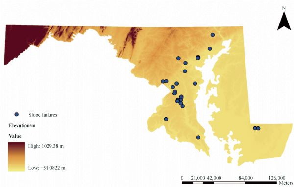
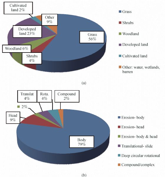
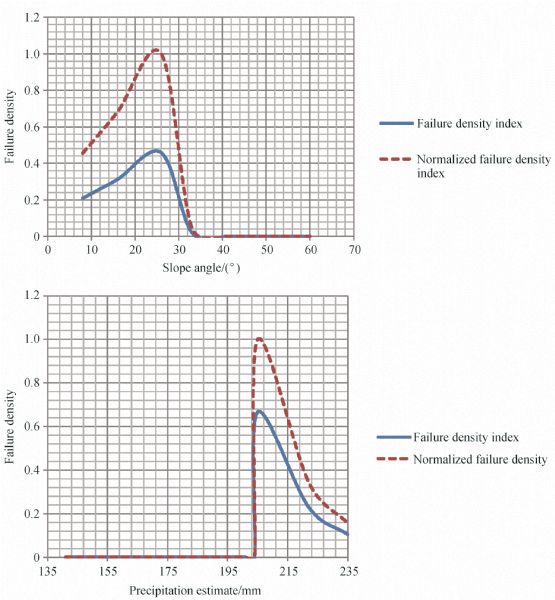
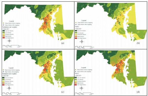
Abstract A framework for preparation of an early warning system was developed for Maryland, using a GIS database and a collective overlay of maps that highlight highway slopes susceptible to soil slides or slope failures in advance through spatial and statistical analysis. Data for existing soil slope failures was collected from geotechnical reports and field visits. A total of 48 slope failures were recorded and analyzed. Six factors, including event precipitation, geological formation, land cover, slope history, slope angle, and elevation were considered to affect highway soil slope stability. The observed trends indicate that precipitation and poor surface or subsurface drainage conditions are principal factors causing slope failures. 96% of the failed slopes have an open drainage section. A majority of the failed slopes lie in regions with relatively high event precipitation (P>200 mm). 90% of the existing failures are surficial erosion type failures, and only 1 out of the 42 slope failures is deep rotational type failure. More than half of the analyzed slope failures have occurred in regions having low density land cover. 46% of failures are on slopes with slope angles between 20° and 30°. Influx of more data relating to failed slopes should give rise to more trends, and thus the developed slope management system will aid the state highway engineers in prudential budget allocation and prioritizing different remediation projects based on the literature reviewed on the principles, concepts, techniques, and methodology for slope instability evaluation (Leshchinsky et al., 2015).
|
| Keywords
soil slope
slope management system
geographic information system
hazard mapping
|
|
Corresponding Author(s):
Ahmet H. AYDILEK
|
|
Just Accepted Date: 03 December 2014
Online First Date: 28 January 2015
Issue Date: 30 April 2015
|
|
| 1 |
P Aleotti, R Chowdhury (1999). Landslide hazard assessment: summary review and new perspectives. Bull Eng Geol Environ, 58(1): 21–44
https://doi.org/10.1007/s100640050066
|
| 2 |
R Anbalagan, B Singh (1996). Landslide hazard and risk assessment mapping of mountainous terrains—A case study from Kumaun Hymalaya, India. Eng Geol, 43(4): 237–246
https://doi.org/10.1016/S0013-7952(96)00033-6
|
| 3 |
U S Army (2003). Living on the Coast: Protecting Investments in Shore Property on the Great Lakes. Great Lakes Hydraulics and Hydrology Office, Detroit District, U.S. Army Corps of Engineers, Detrioit, MI.
|
| 4 |
BBC (2014). Japan landslides kill 32 in Hiroshima prefecture.
|
| 5 |
P Bhattarai, B Tiwari, H Marui, K Aoyama (2004). Quantitative Slope Stability Mapping With ArcGIS: Prioritize Highway Maintenance. Proceedings of ESRI’s 24th Annual International User’s Conference, San Diego. ESRI.
|
| 6 |
D Brundsen (1973). Application of systems theory to the study of mass movement. Geologica e Idrogeologia, Univ. of Baria.
|
| 7 |
M Cardinali, P Reichenbach, F Guzzetti, F Ardizzone, G Antonini, M Galli, M Cacciano, M Castellani, P Salvati (2002). A geomorphological approach to the estimation of landlside hazards and risks in Umbria, Central Italy. Nat Hazards Earth Syst Sci, 2(1/2): 57–72
https://doi.org/10.5194/nhess-2-57-2002
|
| 8 |
A Carrara, F Guzzetti, M Cardinali, P Reichenbach (1999). Use of GIS technology in the prediction and monitoring of landslide hazard. Nat Hazards, 20(2/3): 117–135
https://doi.org/10.1023/A:1008097111310
|
| 9 |
A Cavallo, M F Norese (2001). GIS and Multicriteria Analysis to Evaluate Map Erosion and Landslide Hazards. Informatica., 12: 25–44 (Lithunian Academy of Sciences.)
|
| 10 |
R Chase, T Edil, A Kehew, P Keillor, D Mickelson (2005). Stabilizing Coastal Slopes on the Great Lakes, University of Wisonsin Se Grant Institute, Madison, WI.
|
| 11 |
K T Chau, Y L Sze , M K Fung, W Y Wong, E L Fong, L C P Chan (2004). Landslide hazardanalysis for Hong Kong using landslide inventory and GIS. Computers and Geosciences, 30(4): 429–443
|
| 12 |
C J F Chung, A G Fabbri (1999). Probabilistic Prediction Models for Landslide Hazard Mapping. Photogramm Eng Remote Sensing, 65(12): 1389–1399
|
| 13 |
A Clerici, S Perego, C Tellini, P Vescovi (2002). A procedure for landslide susceptibility zonation by the conditional analysis method. Geomorphology, 48(4): 349–364
https://doi.org/10.1016/S0169-555X(02)00079-X
|
| 14 |
D M Cruden, D J Varnes (1996). Landslides: types and processes. In: A K Turner, L R Schuster, eds. Landslides: Investigation and Mitigation. Transportation Research Board Special Report, No. 247, 36–75
|
| 15 |
F C Dai, C F Lee (2002). Landslide characterisitcs and slope instability modelling using GIS, Lantau Island, Hong Kong. Geomorphology, 42(3–4): 213–228
https://doi.org/10.1016/S0169-555X(01)00087-3
|
| 16 |
R Dikau, D Brundsen, L Schrott, M L Ibsen (1996). Landslide Recognition: Identification, Movement and Causes. Chichester: John Wiley & Sons Ltd., 274 p
|
| 17 |
J Edwards Jr (1981). A brief description of the geology of Maryland. Pamphlet Series. Maryland Geological Survey
|
| 18 |
M Fall, R Azzam, C Noubactep (2006). A multi-method approach to study the stability of natural slopes and landslide susceptibility mapping. Eng Geol, 82(4): 241–263
https://doi.org/10.1016/j.enggeo.2005.11.007
|
| 19 |
V Fenti, S Silvano, V Spagna (1979). Methodological proposal for an engineering geomorphological map, forecasting rockfalls in the Alps. Bulletin of the International Association of Engineering Geology, 19(1): 134–138
https://doi.org/10.1007/BF02600465
|
| 20 |
B Freitag, S Bolton, F Westerlund, J Clark (2009). Floodplain Management: A New Approach for a New Era. Island Press, p 77
|
| 21 |
T Glade, M Anderson, M J Crozier (2005). Landslide Hazard and Risk. West Sussex: John Wiley & Sons, Inc., 824 p
|
| 22 |
P V Gorsevski, P E Gessler, R B Foltz, W J Elliot (2006). Spatial Prediction of Landslide Hazard Using Logistic Regression and ROC Analysis. Transactions in GIS, 10(3): 395–415
https://doi.org/10.1111/j.1467-9671.2006.01004.x
|
| 23 |
P Gupta, R Anbalagan (1997). Slope stability of Theri Dam Reservoir Area, India, using landslide hazard zonation (LHZ) mapping. Q J Eng Geol, 30(1): 27–36
https://doi.org/10.1144/GSL.QJEGH.1997.030.P1.03
|
| 24 |
F Guzzetti, A Carrara, M Cardinali, P Reichenbach (1999). Landslide hazard evaluation: a review of current techniques and their application in a multi-scale study, Central Italy. Geomorphology, 31(1–4): 181–216
https://doi.org/10.1016/S0169-555X(99)00078-1
|
| 25 |
Y He, E R Beighley (2008). GIS-based regional landslide susceptibility mapping: a case study in southern California. Earth Surf Process Landf, 33(3): 380–393
https://doi.org/10.1002/esp.1562
|
| 26 |
H Kienholz (1978). Maps of geomorphology and natural hazard of Griendelwald, Switzerland, scale 1:10 000. Artic and Alpine Research 10: 169–184
|
| 27 |
KING5 (2014). Oso landslide body officially identified, KING5.com
|
| 28 |
S Lee, J Choi (2004). Landslide susceptibility mapping using GIS and the weight-of-evidence model. Int J Geogr Inf Sci, 18(8): 789–814
https://doi.org/10.1080/13658810410001702003
|
| 29 |
E Leroi (1996). Landslide hazard-risk maps at different scales: objectives, tools and developements. In: Senneset K, ed. Landslides. Rotterdam: Balkema, 35–51
|
| 30 |
B Leshchinsky, M Olsen, B F Tanyu (2015). Contour connection method for automated identification and classification of landslide deposits. Journal of Computers and Geosciences, 74: 27–38
https://doi.org/10.1191/0309133305pp462ra
|
| 31 |
W J McGee (1888). The Geology of the Head of Chesapeake Bay. Geological Survey 7th Annual Report, 537–646
|
| 32 |
D M Morton, R M Alvares, R H Campbell (2003). Preliminary Soil-Slip Susceptibility Maps, Southwestern California, US Geological Survey Open-File Report 03–17
|
| 33 |
NRC (2004). Partnerships for Reducing Landslide Risk: Assessment of the National Landslide Hazards Mitigation Strategy. National Research Council, National Academies Press: Washington, DC; 131
|
| 34 |
M E Popescu (2002). Landslide Causal Factors and Landslide Remedial Options. Proceedings 3rd International Conference on Landslides, Slope Stability and Safety of Infra-Structures, Singapore. 61–81
|
| 35 |
R S Ramanathan (2012). Soil Slope Failure Investigation Management System. M.S. Thesis, University of Maryland, College Park, MD, 121 p
|
| 36 |
J Rupke, E Cammeraat, A C Seijmonsbergen, C J V van Westen (1988). Engineering geomorphology of Widentobel Catchment, Appenzell and Sankt Gallen, Switzerland: a geomorphological inventory system applied to geotechnical appraisal of slope stability. Eng Geol, 26(1): 33–68
https://doi.org/10.1016/0013-7952(88)90005-1
|
| 37 |
F Saboya, M da Glória Alves, Dias W Pinto (2006). Assessment of failure susceptibility of soil slopes using fuzzy logic. Eng Geol, 86(4): 211–224
https://doi.org/10.1016/j.enggeo.2006.05.001
|
| 38 |
M G Sakellariou, M D Ferentinou (2001). GIS-based estimation of Slope Stability. Nat Hazards Rev, 2(1): 12–21
https://doi.org/10.1061/(ASCE)1527-6988(2001)2:1(12)
|
| 39 |
M J Selby (1993). Hillslope Materials and Processes. Oxford University Press, 451 p
|
| 40 |
H Singh, B B Huat (2008). Slope Assessment Systems: a review and evaluation of current techniques used for cut slopes in mountainous terrain of West Malaysia. Electronic Journal of Geotechnical Engineering, 13: 1–24
|
| 41 |
A W Skempton (1953). Soil Mechanics in relation to geology. Proceedings of the Yorkshire Geology Society, 29(1): 33–62
https://doi.org/10.1144/pygs.29.1.33
|
| 42 |
A K Turner, R L Schuster (1996). Lanslides: Investigation and Mitigation. Washington D.C.: National Academy Press, 673 p
|
| 43 |
U. S. Census Bureau (2011). “2010 Resident Population Data”. U. S. Census Bureau. Retrieved 26 December 2010.
|
| 44 |
USGS (2004). Lanslides Types and Processes, Fact Sheet 2004–3072, U.S. Department of the Interior, U.S. Geological Survey
|
| 45 |
C J van Westen, N Rengers, M T J Terlien, R Soeters. (1997). Prediction of the occurrence of slope instability phenomena through GIS-based hazard zonation. Geol Rundsch, 86: 404–414
|
| 46 |
D J Wachal, P F Hudak (2000). Mapping landslide susceptibility in Travis County, Texas, USA. GeoJournal, 51(3): 245–253
https://doi.org/10.1023/A:1017524604463
|
| 47 |
H Wang, G Liu, W Xu, G Wang (2005). GIS-based landslide hazard assessment: an overview. Prog Phys Geogr, 29(4): 548–567
https://doi.org/10.1191/0309133305pp462ra
|
|
Viewed |
|
|
|
Full text
|
|
|
|
|
Abstract
|
|
|
|
|
Cited |
|
|
|
|
| |
Shared |
|
|
|
|
| |
Discussed |
|
|
|
|