|
|
|
Interpretation of gravity data for fault distribution near the Mongolia–Hinggan metallogenic belt in the eastern China-Mongolia frontier area |
Jun WANG1,2( ), Xiaohong MENG1,2(), Zhaoxi CHEN1,2, Fang LI3 ), Xiaohong MENG1,2(), Zhaoxi CHEN1,2, Fang LI3 |
1. Key Laboratory of Geo-detection (China University of Geosciences, Beijing), Ministry of Education, Beijing 100083, China
2. School of Geophysics and Information Technology, China University of Geosciences, Beijing 100083, China
3. China Aero Geophysical Survey and Remote Sensing Center for Land and Resources, Beijing 100083, China |
|
|
|
|
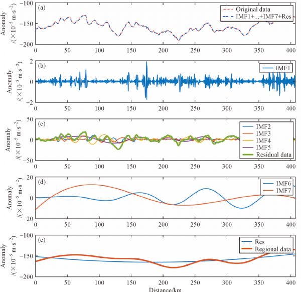
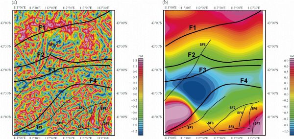
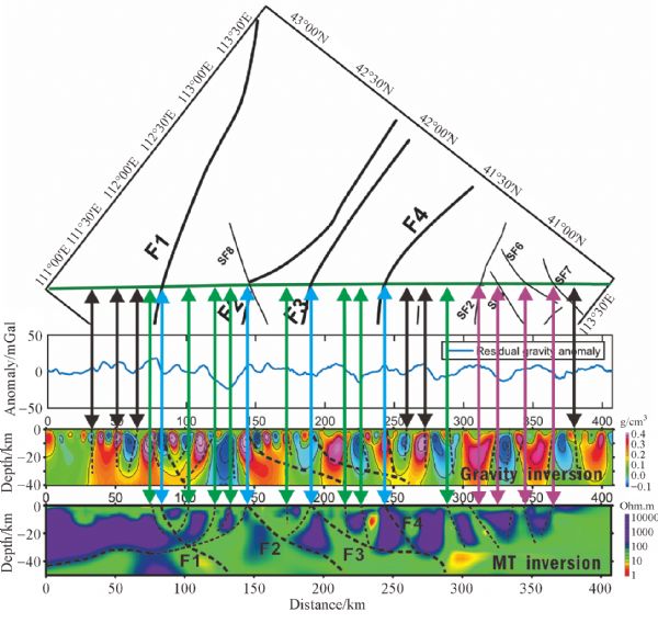
Abstract The Central Asian Orogenic Belt (CAOB) is a giant suture zone produced by the reduction of the Paleo-Asian Ocean between the Siberian, North China, and Tarim cratons. The CAOB formed in three main stages, including continental accretion, late collision, and intracontinental orogeny. Strong crust-mantle interaction also occurred during these stages. The eastern China-Mongolia frontier area is an important part of the CAOB. Since the Caledonian period, this region has frequently experienced polycyclic tectonic reformation and intense magmatic activities. All of these geological activities lay the foundation for abundant metal resources. In the past, several large metal ore deposits have been founded there. However, the deep structure of different tectonic units and the fault distribution in the eastern China-Mongolia border frontier area are still not clear owing to the complex geological environment. Existing works in that region are insufficient for an in-depth understanding of the metallogenic deposits. The work discussed in this paper was carried out in the eastern China-Mongolia frontier area with measured gravity data along a profile and gravity data extracted from the WGM2012 earth’s gravity model for detailed fault distribution. In this study, empirical mode decomposition (EMD) and tilt angle analysis (TDR) were utilized for processing the gridded gravity data. The measured gravity data were inverted with a 2D inversion algorithm for density distribution along the survey line. The inversion result was used to verify the existence of known faults and describe their deeper extensions. Meanwhile, new faults were also identified along the survey line and then marked on the gridded data to get their horizontal distribution. These results provide significant information for the in-depth understanding of the tectonic units in the study area.
|
| Keywords
the CAOB
China-Mongolia frontier area
gravity data
processing and inversion
fault distribution
|
|
Corresponding Author(s):
Jun WANG,Xiaohong MENG
|
|
Online First Date: 13 August 2018
Issue Date: 20 November 2018
|
|
| 1 |
Ali-Rahim M A (2016). Separating the gravity field of Iraq by using bidimensional empirical mode decomposition technique. Arab J Geosci, 9(1): 1–9
|
| 2 |
Amante C, Eakins B W (2009). ETOPO1 1 Arc-Minute Global Relief Model: Procedures, Data Sources and Analysis. NOAA Technical Memorandum NESDIS NGDC-24
|
| 3 |
Balmino G, Vales N, Bonvalot S, Briais A (2012). Spherical harmonic modeling to ultra-high degree of Bouguer and isostatic anomalies. J Geod, 86(7): 499–520
https://doi.org/10.1007/s00190-011-0533-4
|
| 4 |
Blakely R J, Simpson R W (1986). Approximating edges of source bodies from magnetic or gravity anomalies. Geophysics, 51(7): 1494–1498
https://doi.org/10.1190/1.1442197
|
| 5 |
Chen Y, Ma J (2014). Random noise attenuation by f-x empirical mode decomposition predictive filtering. Geophysics, 79(3): V81–V91
https://doi.org/10.1190/geo2013-0080.1
|
| 6 |
Didenko A N, Kaplun V B, Malyshev Y F, Shevchenko B F (2010). Lithospheric structure and Mesozoic geodynamics of the Eastern Central Asian orogeny. Russ Geol Geophys, 51(5): 492–506
https://doi.org/10.1016/j.rgg.2010.04.006
|
| 7 |
Fedi M, Florio G (2001). Detection of potential fields source boundaries by enhanced horizontal derivative method. Geophys Prospect, 49(1): 40–58
https://doi.org/10.1046/j.1365-2478.2001.00235.x
|
| 8 |
Ghosh G K (2016). Interpretation of gravity data using 3D euler deconvolution, tilt angle, horizontal tilt angle and source edge approximation of the North-West Himalaya. Acta geophysics, 64(4): 1112–1138
|
| 9 |
Guo L H, Meng X H, Zhang G L (2014). Three-dimensional correlation imaging for total amplitude magnetic anomaly and normalized source strength in the presence of strong remnant magnetization. J Appl Geophys, 111: 121–128
https://doi.org/10.1016/j.jappgeo.2014.10.007
|
| 10 |
Huang N E, Shen Z, Long S R, Wu M C, Shih H H, Zheng Q, Yen N C, Tung C C, Liu H H (1998). The empirical mode decomposition and the Hilbert spectrum for nonlinear and non-stationary time series analysis. Proc R Soc Lond A, 454(1971): 903–995
https://doi.org/10.1098/rspa.1998.0193
|
| 11 |
Jahn B, Capdevila R, Liu D, Vernov A, Badarch G (2004). Sources of Phanerozoic granitoids in the transect Bayanhongor-Ulan Baator, Mongolia: geochemical and Nd isotopic evidence, and implications of Phanerozoic crustal growth. J Asian Earth Sci, 23(5): 629–653
https://doi.org/10.1016/S1367-9120(03)00125-1
|
| 12 |
Li L, Ji H B (2009). Signal feature extraction based on an improved EMD method. Measurement, 42(5): 796–803
https://doi.org/10.1016/j.measurement.2009.01.001
|
| 13 |
Li Y G, Oldenburg D W (1998). 3-D inversion of gravity data. Geophysics, 63(1): 109–119
https://doi.org/10.1190/1.1444302
|
| 14 |
Liu Y, Lü Q T, Li X B, Qi G, Zhao J H, Yan J Y, Deng Z (2015). 3D gravity inversion based on Bayesian method with model order reduction. Chin J Geophys, 58(12): 4727–4739
|
| 16 |
Metcalfe I (2006). Paleozoic and Mesozoic tectonic evolution and paleogeography of East Asian crustal fragments: the Korean Peninsula in context. Gondwana Res, 9(1‒2): 24–46
https://doi.org/10.1016/j.gr.2005.04.002
|
| 17 |
Miller H G, Singh V (1994). Potential field tilt – A new concept for location of potential field sources. J Appl Geophys, 32(2): 213–217
https://doi.org/10.1016/0926-9851(94)90022-1
|
| 18 |
Mossakovsky A A, Ruzhentsev S V, Samygin S G, Kheraskova T N (1993). The Central Asian fold belt: geodynamic evolution and formation history. Geotectonics, 26: 455–473
|
| 19 |
Nabighian M N, Ander M E, Grauch V J S, Hansen R O, Lafehr T R, Li Y, Pearson W C, Peirce J W, Phillips J D, Ruder M E (2005). Historical development of the gravity method in exploration. Geophysics 70(6): 63ND–89ND
|
| 20 |
Nie F J, Jiang S H, Zhang Y, Liu Y, Hu P (2004). Geological features and origin of porphyry copper deposits in China-Mongolia border region and its neighboring areas. Mineral deposits, 23(2): 176–189
|
| 21 |
Nunes J C, Guyot S, Deléchelle E (2005). Texture analysis based on local analysis of the bidimensional empirical mode decomposition. Mach Vis Appl, 16(3): 177–188
https://doi.org/10.1007/s00138-004-0170-5
|
| 22 |
Oru Bç (2011). Edge detection and depth estimation using a tilt angle map from gravity gradient data of the Kozaklı-Central Anatolia Region, Turkey. Pure Appl Geophys, 168(10): 1769–1780
https://doi.org/10.1007/s00024-010-0211-0
|
| 23 |
Perello J, Cox D, Garamjav D, Sanjdorj S, Diakov S, Schissel D, Munkhbat T O, Oyun G (2001). Oyu Tolgoi, Mongolia: Siluro-Devonian Porphyry Cu-Au-(Mo) and High-Sulfidation Cu Mineralization with a Cretaceous chalcocite blanket. Econ Geol, 96(6): 1407–1428
https://doi.org/10.2113/gsecongeo.96.6.1407
|
| 24 |
Phillips J D, Hansen R O, Blakely R J (2007). The use of curvature in potential-field interpretation. Explor Geophys, 38(2): 111–119
https://doi.org/10.1071/EG07014
|
| 25 |
Uieda L, Barbosa V C F (2012). Robust 3D gravity gradient inversion by planting anomalous densities. Geophysics, 77(4): G55–G66
https://doi.org/10.1190/geo2011-0388.1
|
| 26 |
Verduzco B, Fairhead J D, Green C M, MacKenzie C (2004). New insights into magnetic derivatives for structural mapping. Leading Edge (Tulsa Okla), 23(2): 116–119
https://doi.org/10.1190/1.1651454
|
| 27 |
Wang J, Meng X H, Guo L H, Chen Z X, Li F (2014). A correlation-based approach for determining the threshold value of singular value decomposition filtering for potential field data denoising. Journal of Geophys and Engineering, 11 (5): 055007
|
| 28 |
Wang J, Meng X H, Li F (2015a). Improved curvature gravity gradient tensor with principal component analysis and its application in edge detection of gravity data. J Appl Geophys, 118: 106–114
https://doi.org/10.1016/j.jappgeo.2015.04.013
|
| 29 |
Wang J, Meng X H, Li F (2015b). A computationally efficient scheme for the inversion of large scale potential field data: application to synthetic and real data. Comput Geosci, 85: 102–111
https://doi.org/10.1016/j.cageo.2015.09.005
|
| 30 |
Williams S E, Fairhead J D, Flanagan G (2005). Comparison of grid Euler deconvolution with and without 2D constraints using a realistic 3D magnetic basement model. Geophysics, 70(3): L13–L21
https://doi.org/10.1190/1.1925745
|
| 31 |
Xiao W J, Huang B C, Han C M, Sun S, Li J L (2010). A review of the western part of the Altaids: a key to understanding the architecture of accretionary orogens. Gondwana Res, 18(2‒3): 253–273
https://doi.org/10.1016/j.gr.2010.01.007
|
| 32 |
Yan J Y, Lu Q T, Wu M A, Chen X B, Zhang K, Qi G (2014). Prospecting indicator of Anhui Shaxi porphyry copper deposits based on regional gravity and magnetic 3D inversion. Acta Geol Sin, 88(4): 507–518
|
| 33 |
Yarmolyuk V V, Kuzmin M I, Ernst R E (2014). Intraplate geodynamics and magmatism in the evolution of the Central Asian Orogenic Belt. J Asian Earth Sci, 93: 158–179
https://doi.org/10.1016/j.jseaes.2014.07.004
|
|
Viewed |
|
|
|
Full text
|
|
|
|
|
Abstract
|
|
|
|
|
Cited |
|
|
|
|
| |
Shared |
|
|
|
|
| |
Discussed |
|
|
|
|