|
|
|
Coarse and fine sediment transportation patterns and causes downstream of the Three Gorges Dam |
Songzhe LI1, Yunping YANG1,2( ), Mingjin ZHANG2, Zhaohua SUN3, Lingling ZHU4, Xingying YOU5, Kanyu LI6 ), Mingjin ZHANG2, Zhaohua SUN3, Lingling ZHU4, Xingying YOU5, Kanyu LI6 |
1. State Key Laboratory of Hydraulic Engineering Simulation and Safety, Tianjin University, Tianjin 300072, China
2. Key Laboratory of Engineering Sediment, Tianjin Research Institute for Water Transport Engineering, Ministry of Transport, Tianjin 300456, China
3. State Key Laboratory of Water Resources and Hydropower Engineering Science, Wuhan University, Wuhan 430072, China
4. Bureau of Hydrology, Changjiang Water Resources Commission, Wuhan 430010, China
5. Hubei Provincial Water Resources and Hydropower Planning Survey and Design Institute, Wuhan 430064, China
6. Changjiang Waterway Bureau, Wuhan 430010, China |
|
|
|
|
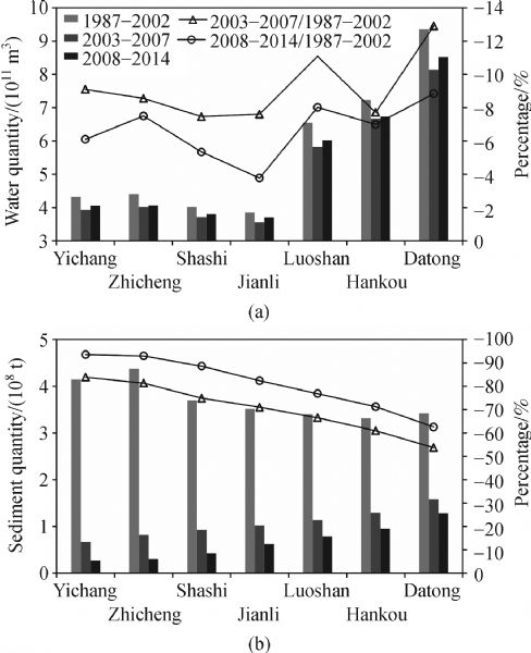
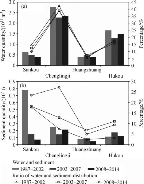
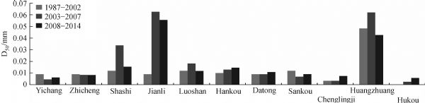
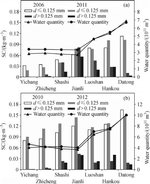
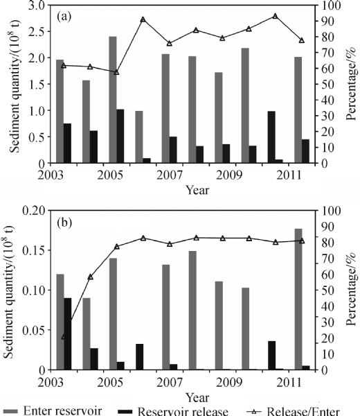
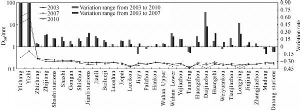
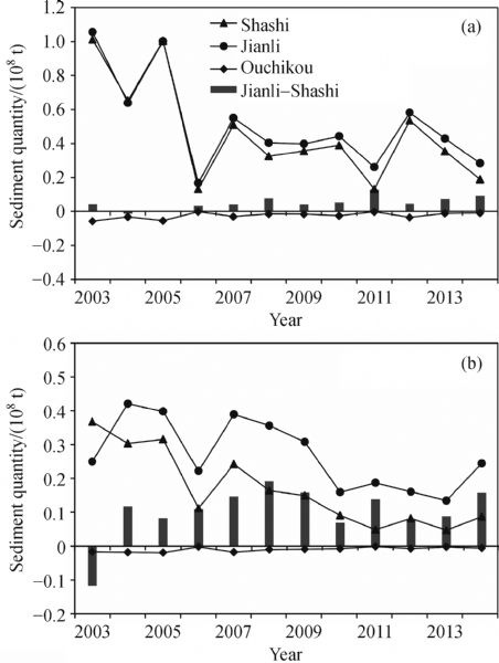
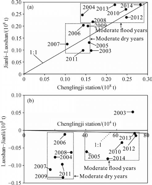
Abstract Reservoir construction within a basin affects the process of water and sediment transport downstream of the dam. The Three Gorges Reservoir (TGR) affects the sediment transport downstream of the dam. The impoundment of the TGR reduced total downstream sediment. The sediment group d≤0.125 mm (fine particle) increased along the path, but the average was still below what existed before the reservoir impoundment. The sediments group d>0.125 mm (coarse particle) was recharged in the Yichang to Jianli reach, but showed a deposition trend downstream of Jianli. The coarse sediment in the Yichang to Jianli section in 2003 to 2007 was above the value before the TGR impoundment. However, the increase of both coarse and fine sediments in 2008 to 2014 was less than that in 2003 to 2007. The sediment retained in the dam is the major reason for the sediment reduction downstream. However, the retention in different river reaches is affected by riverbed coarsening, discharge, flow process, and conditions of lake functioning and recharging from the tributaries. The main conclusions derived from our study are as follows: 1) The riverbed in the Yichang to Shashi section was relatively coarse, thereby limiting the supply of fine and coarse sediments. The fine sediment supply was mainly controlled by TGR discharge, whereas the coarse sediment supply was controlled by the duration of high flow and its magnitude. 2) The supply of both coarse and fine sediments in the Shashi to Jianli section was controlled by the amount of total discharge. The sediment supply from the riverbed was higher in flood years than that in the dry years. The coarse sediment tended to deposit, and the deposition in the dry years was larger than that in the flood years. 3) The feeding of the fine sediment in the Luoshan to Hankou section was mainly from the riverbed. The supply in 2008 to 2014 was more than that in 2003 to 2007. Around 2010, the coarse sediments transited from depositing to scouring that was probably caused by the increased duration of high flow days. 4) Fine sediments appeared to be deposited in large amounts in the Hankou to Jiujiang section. The coarse sediment was fed by the riverbed scouring, and much more coarse sediments were recharged from the riverbed in the flood years than in the dry years. 5) In the Jiujiang to Datong section, the ratio of fine sediments from the Poyang Lake and that from the riverbed was 1: 2.82. The sediment from the riverbed scouring contributed more to the coarse sediment transportation. The contribution was mainly affected by the input by magnitude and duration of high flows.
|
| Keywords
grouped sediments
genetic analysis
Three Gorges reservoir
transportation characteristics
middle and lower reaches of Yangtze River
|
|
Corresponding Author(s):
Yunping YANG
|
|
Just Accepted Date: 13 September 2017
Online First Date: 14 November 2017
Issue Date: 20 November 2018
|
|
| 1 |
Benn P C, Erskine W D (1994). Complex channel response to flow regulation: Cudgegong River below Windermere Dam, Australia. Appl Geogr, 14(2): 153–168
https://doi.org/10.1016/0143-6228(94)90058-2
|
| 2 |
Chen F, Li Y T (2009). Analysis of the characters of erosion and deposition downstream from the reservoir. In: Zhang C K, Tang H W, eds. Advances in Water Resources and Hydraulic Engineering. Springer Berlin Heidelberg, 797–802
|
| 3 |
Chen J G, Zhou W H, Yuan Y P (2002). Transportation and adjustment of different grain sized sediment along the lower Yellow River under typical operation modes of Sanmenxia reservoir. J Sediment Res, (2): 15–22 (in Chinese)
|
| 4 |
Dai Z J, Chu A, Stive M, Du J Z, Li J F (2011). Is the Three Gorges Dam the cause behind the extremely low suspended sediment discharge into the Yangtze (Changjiang) Estuary of 2006? Hydrol Sci J, 56(7): 1280–1288
https://doi.org/10.1080/02626667.2011.585136
|
| 5 |
Ge H, Zhu L L, Zhang X B (2011). Analysis of no uniform sediment recovery coefficient downstream from reservoir. Engineering Journal of Wuhan University, 44(6): 711–715 (in Chinese)
|
| 6 |
Guo X H, Li Y T, Qu G, Liu X Y (2014). Analysis of sediment transport in Middle Yangtze River after filling of the Three Gorges Reservoir. J Sediment Res, (5): 11–17 (in Chinese)
|
| 7 |
Han J Q (2015). The interaction mechanism between longitudinal water and sediment transport and channel morphology in the downstream of Three Gorges Reservoir. Dissertation for PhD. degree. Wuhan University (in Chinese)
|
| 8 |
Hydrology Bureau, Changjiang Water Resource Commission (HBCWRC) (2002). Analysis of river bed erosion downstream from Danjiangkou reservoir in period of retardation and period of water impoundment. Sediment Research of Three Gorge Project (Vol.7). Beijing: Intellectual Property Press, 75–82 (in Chinese)
|
| 9 |
Jiang L Z, Ban X, Wang X L, Cai X B (2014). Assessment of hydrologic alterations caused by the Three Gorges Dam in the middle and lower reaches of Yangtze River, China. Water, 6(5): 1419–1434
https://doi.org/10.3390/w6051419
|
| 10 |
Li Q F, Yu M X, Lu G B, Cai T, Bai X, Xia Z Q (2011). Impacts of the Gezhouba and Three Gorges Reservoirs on the sediment regime in the Yangtze River, China. J Hydrol (Amst), 403(3-4): 224–233
https://doi.org/10.1016/j.jhydrol.2011.03.043
|
| 11 |
Li Y T, Sun Z H, Deng J Y (2003). A study on riverbed erosion downstream from the Three Gorges Reservoir. Journal of Basic Science and Engineering, 11(3): 283–295 (in Chinese)
https://doi.org/10.1063/1.1618595
|
| 12 |
Liu C, Sui J Y, He Y, Hirshfield F (2013). Changes in runoff and sediment load from major Chinese rivers to the Pacific Ocean over the period 1955–2010. Int J Sediment Res, 28(4): 486–495
https://doi.org/10.1016/S1001-6279(14)60007-X
|
| 13 |
Luo X X, Yang S L, Zhang J (2012). The impact of the Three Gorges Dam on the downstream distribution and texture of sediments along the middle and lower Yangtze River (Changjiang) and its estuary and subsequent sediment dispersal in the East China Sea. Geomorphology, 179(1): 126–140
https://doi.org/10.1016/j.geomorph.2012.05.034
|
| 14 |
Wang H J, Yang Z S, Wang Y, Saito Y, Liu J P (2008). Reconstruction of sediment flux from the Changjiang (Yangtze River) to the sea since the 1860s. J Hydrol (Amst), 349(3–4): 318–332
https://doi.org/10.1016/j.jhydrol.2007.11.005
|
| 15 |
Xu J X, Hu C H, Chen J G (2009). Effect of suspended sediment grain size on channel sedimentation in the lower Yellow River and some implications. Science in China Series E: Technological Sciences, 52(8): 2330–2339
https://doi.org/10.1007/s11431-008-0269-4
|
| 16 |
Yang S L, Xu K H, Milliman J D, Yang H F, Wu C S (2015a). Decline of Yangtze River water and sediment discharge: impact from natural and anthropogenic changes. Sci Rep, 5(1): 12581
https://doi.org/10.1038/srep12581
|
| 17 |
Yang Y P, Deng J Y, Zhang M J, Li Y T, Liu W L (2015b). The synchronicity and difference in the change of suspended sediment concentration in the Yangtze River Estuary. J Geogr Sci, 25(4): 399–416
https://doi.org/10.1007/s11442-015-1176-9
|
| 18 |
Yang Y P, Li Y T, Sun Z H, Fan Y Y (2014). Suspended sediment load in the turbidity maximum zone at the Yangtze River Estuary: the trends and causes. J Geogr Sci, 24(1): 129–142
https://doi.org/10.1007/s11442-014-1077-3
|
| 19 |
Yang Y P, Zhang M J, Li Y T, Zhang W (2015c). The variations of suspended sediment concentration in Yangtze River Estuary. J Hydrodynam, 27(6): 845–856
https://doi.org/10.1016/S1001-6058(15)60547-9
|
| 20 |
Yang Y P, Zhang M J, Li Y T, Zhang W, You X Y, Zhu L L, Wang D (2016). Suspended sediment recovery and bedsand compensation mechanisn sffected by the Three Gorges Project. Acta Geogr Sin, 71(7): 1241–1254 (in Chinese)
|
| 21 |
Zhang W, Yang Y P, Zhang M J, Li Y, Zhu L L, You X Y, Wang D, Xu J F (2017). Mechanisms of suspended sediment restoration and bed level compensation in downstream reaches of the Three Gorges Project (TGP). J Geogr Sci, 27(4): 463–480
https://doi.org/10.1007/s11442-017-1387-3
|
| 22 |
Zhao G S, Lu J Y, Visser P J (2015). Fluvial river regime in disturbed river systems: a case study of evolution of the Middle Yangtze River in Post-TGD (Three Gorges Dam), China. Journal of Geology & Geophysics, 4(6): 1–4
https://doi.org/10.4172/2381-8719.1000228
|
| 23 |
Zhu L L, Ge H, Li Y, Zhang W (2015). Branching Channels in the Middle Yangtze River, China. Journal of Basic Science and Engineering, 23(2): 246–258 (in Chinese)
|
| 24 |
Zhu L L, Ge H, Zhang X B, Li Y T (2012). Preliminary study on responses of non-uniform sediment scouring and silting in the middle Yangtze to its inflows. Journal of Hydroelectric Engineering, 30(6): 215–221 (in Chinese)
|
|
Viewed |
|
|
|
Full text
|
|
|
|
|
Abstract
|
|
|
|
|
Cited |
|
|
|
|
| |
Shared |
|
|
|
|
| |
Discussed |
|
|
|
|