|
|
|
The impact of rapid urban expansion on coastal mangroves: a case study in Guangdong Province, China |
Bin AI1,2,3, Chunlei MA1( ), Jun ZHAO1,2,3, Rui ZHANG1 ), Jun ZHAO1,2,3, Rui ZHANG1 |
1. School of Marine Sciences, Sun Yat-Sen University, Guangzhou 510275, China
2. Guangdong Provincial Key Laboratory of Marine Resources and Coastal Engineering, Guangzhou 510275, China
3. Southern Marine Science and Engineering Guangdong Laboratory (Zhuhai), Zhuhai 519000, China |
|
|
|
|
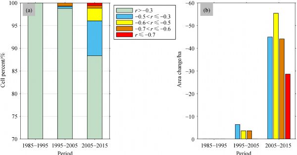
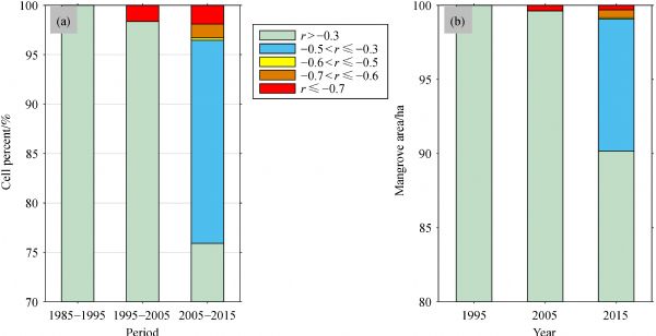
Abstract Mangroves serve many important ecological functions and consequently represent a dominant coastal ecosystem. However, coastal regions are very susceptible to ecological damage due to their high population density, urban expansion being one of the most important influencing factors. Accordingly, it is vital to ascertain how urban expansion endangers mangrove ecosystems. This study used the decision-tree classification method based on classification and regression tree (CART) algorithm to extract areas of mangrove and built-up land from Landsat images. A correlation analysis was performed between the change in the area of mangroves and the change in the area of built-up land at the cell scale. This study aimed to reveal the magnitude of the influence of urban expansion on mangrove forests in different periods and in different regions, and to identify the places that are seriously affected by urban expansion. The results demonstrate that this approach can be used to quantitatively analyze the impact of urban expansion on mangrove forests, and show that larger areas of mangrove were affected by urban expansion in the past 30 years. The effects of urban expansion were stronger over time, with approximately 12% of cells containing mangroves showing a negative correlation between the increase in the area of built-up land and the change in the area of mangrove forests to different degrees from 2005 to 2015. The same quantitative analysis was also carried out in three subregions of Guangdong Province, namely western Guangdong Province, the Pearl River Delta, and eastern Guangdong Province. It was found that the situations in these three regions were very different due to discrepancies in the distribution of mangroves, the rate of urban expansion, and the awareness of the local government regarding environmental protection. These results can assist in the management of coastal cities and the protection of mangrove ecosystems.
|
| Keywords
mangrove
urban expansion
ecological stress
coastal Guangdong
|
|
Corresponding Author(s):
Chunlei MA
|
|
Just Accepted Date: 11 September 2019
Online First Date: 07 November 2019
Issue Date: 24 March 2020
|
|
| 1 |
D M Alongi (2015). The impact of climate change on Mangrove Forests. Curr Clim Change Rep, 1(1): 30–39
https://doi.org/10.1007/s40641-015-0002-x
|
| 2 |
D. G. Bengen, (2001). Coastal and marine ecosystems and natural resources: synopsis. Institute of Coastal and Ocean Resources Institute. Bogor Agriculture
|
| 3 |
BETTS, T. (2006). An Assessment of Mangrove Cover and Forest Structure in Las Perlas, Panama. Dissertation for Master’s Degree. Edinburgh: Heriot-Watt University
|
| 4 |
G Chander, B L Markham, D L Helder (2009). Summary of current radiometric calibration coefficients for Landsat MSS, TM, ETM+, and EO-1 ALI sensors. Remote Sens Environ, 113(5): 893–903
https://doi.org/10.1016/j.rse.2009.01.007
|
| 5 |
G Chandra, Z Zhu, L Tieszen, A Singh, S Gillette, J A Kelmelis (2007). Mangrove forest distributions and dynamics (1975-2005) of the tsunami-affected region of Asia. J Biogeogr, 35: 519–528
|
| 6 |
B Chen, X Xiao, X Li, L Pan, R Doughty, J Ma, J Dong, Y Qin, B Zhao, Z Wu, R Sun, G Lan, G Xie, N Clinton, C Giri (2017). A mangrove forest map of China in 2015: Analysis of time series Landsat 7/8 and Sentinel-1A imagery in Google Earth Engine cloud computing platform. ISPRS J Photogramm Remote Sens, 131: 104–120
https://doi.org/10.1016/j.isprsjprs.2017.07.011
|
| 7 |
L Chen, W Wang, Y Zhang, G Lin (2009). Recent progresses in mangrove conservation, restoration and research in China. J Plant Ecol, 2(2): 45–54
https://doi.org/10.1093/jpe/rtp009
|
| 8 |
R Estoque, S W Myint, C Wang, A Ishtiaque, T T Aung, L Emerton, M Ooba, Y Hijioka, M S Mon, Z Wang, C Fan (2018). Assessing environmental impacts and change in Myanmar’s mangrove ecosystem service value due to deforestation (2000-2014). Glob Change Biol, 24(11): 5391–5410
https://doi.org/10.1111/gcb.14409
|
| 9 |
H Q Fan (1995). Mangrove resources, human disturbance and rehabilitation action in China. Chin. Biodiv., 3(Suppl.): 49–54
|
| 10 |
FAO (2007). The world’s mangroves 1980-2005. A thematic study prepared in the framework of the global forest resources assessment 2005. Forest Economics and Policy Div. Fon
|
| 11 |
Z Gao, X Liu, J Ning, Q Lu (2014). Analysis on changes in coastline and reclamation area and its causes based on 30-year satellite data in China. Nongye Gongcheng Xuebao, 30: 140–147 (in Chinese)
|
| 12 |
C Giri, B Pengra, Z Zhu, A Singh, L L Tieszen (2007). Monitoring mangrove forest dynamics of the Sundarbans in Bangladesh and India using multi-temporal satellite data from 1973 to 2000. Estuar Coast Shelf Sci, 73(1-2): 91–100
https://doi.org/10.1016/j.ecss.2006.12.019
|
| 13 |
Gunarto (2004). Mangrove conservation as a supporter of coastal fishery biological resources. Agricultural Research and Development Journal, 23(1): 15–21
|
| 14 |
S E Hamilton, D Casey (2016). Creation of a high spatio-temporal resolution global database of continuous mangrove forest cover for the 21st century (CGMFC-21). Glob Ecol Biogeogr, 25(6): 729–738
https://doi.org/10.1111/geb.12449
|
| 15 |
X Han, L Feng, C Hu, P Kramer (2018). Hurricane influenced changes in the Everglades National Park mangrove forest: Landsat observations between 1985 and 2017. J Geophys Res Biogeosci, 123(11): 3470–3488
https://doi.org/10.1029/2018JG004501
|
| 16 |
X Hou, T Wu, W Hou, Q Chen, Y Wang, L Yu (2016). Characteristics of coastline changes in mainland China since the early 1940s. Sci China Earth Sci, 59(9): 1791–1802
https://doi.org/10.1007/s11430-016-5317-5
|
| 17 |
M Jayanthi, S Thirumurthy, G Nagaraj, M Muralidhar, P Ravichandran (2018). Spatial and temporal changes in mangrove cover across the protected and unprotected forests of India. Estuar Coast Shelf Sci, 213: 81–91
https://doi.org/10.1016/j.ecss.2018.08.016
|
| 18 |
J R Jensen (2005). Introductory Digital Image Processing: A Remote Sensing Perspective, third edition. NJ, USA, Upper Saddle River, Prentice Hall, Inc
|
| 19 |
M Jia (2014). Remote Sensing analysis of China’s mangrove forests dynamics during 1973 to 2013. Dissertation for the Doctoral Degree. Beijing: Chinese Academy of Sciences
|
| 20 |
M Jia, Z Wang, L Li, K Song, C Ren, B Liu, D Mao (2014). Mapping China’s mangroves based on an object-oriented classification of Landsat imagery. Wetlands, 34(2): 277–283
https://doi.org/10.1007/s13157-013-0449-2
|
| 21 |
M Jia, Z Wang, Y Zhang, D Mao, C Wang (2018). Monitoring loss and recovery of mangrove forests during 42 years: The achievements of mangrove conservation in China. Int J Appl Earth Obs Geoinf, 73: 535–545
https://doi.org/10.1016/j.jag.2018.07.025
|
| 22 |
K B Kirui, J G Kairo, J Bosire, K M Viergever, S Rudra, M Huxham, R A Briers (2013). Mapping of mangrove forest land cover change along the Kenya coastline using Landsat imagery. Ocean Coast Manage, 83: 19–24
https://doi.org/10.1016/j.ocecoaman.2011.12.004
|
| 23 |
C Kuenzer, A Bluemel, S Gebhardt, T Vo, S Dech (2011). Remote Sensing of Mangrove Ecosystems: A Review. Remote Sens, 3(5): 878–928
https://doi.org/10.3390/rs3050878
|
| 24 |
F Li, H Liang, X Mi, A Wei (2015). A multi-subregions decision tree land cover classification approach using Landsat8 image. Infrared and Laser Engineering, 44(7): 2224–2230
|
| 25 |
K Liu, X Li, X Shi, S Wang (2008). Monitoring mangrove forest changes using remote sensing and GIS data with decision-tree learning. Wetlands, 28(2): 336–346
https://doi.org/10.1672/06-91.1
|
| 26 |
W Liu, B Q Liu (2008). Current situation and countermeasures of sea reclamation in China. Guangzhou Environmental Sciences, 23: 26–30
|
| 27 |
C Lu, J Liu, M Jia, M Liu, W Man, W Fu, L Zhong, X Lin, Y Su, Y Gao (2018). Dynamic Analysis of Mangrove Forests Based on an Optimal Segmentation Scale Model and Multi-Seasonal Images in Quanzhou Bay, China. Remote Sens, 10(12): 2020
https://doi.org/10.3390/rs10122020
|
| 28 |
L Lv, H Luo, B Zhang (2012). Relationship between electricity consumption and economic growth of Guangdong Province in China. Frontiers in Energy, 6(4): 351–355
https://doi.org/10.1007/s11708-012-0209-7
|
| 29 |
T. Lǚ,, X. Zhou, C. Liu, Z. Tao and T. Yongyut (2015). Spatial distribution dataset of mangrove forests in South Asia (Mangrov_SEAsia_2015). Global Change Research Data Publishing and Repository
|
| 30 |
C. Ma,, B. Ai, J. Zhao, X. Xu, and W. Huang (2019). Change Detection of Mangrove Forests in Coastal Guangdong during the Past Three Decades Based on Remote Sensing Data. Remote Sens, 11(8): 921
https://doi.org/10.3390/rs11080921
|
| 31 |
F J Manson, N R Loneragan, I M McLeod, R A Kenyon (2001). Assessing techniques for estimating the extent of mangroves: topographic maps, aerial photographs and Landsat TM images. Mar Freshw Res, 52(5): 787–792
https://doi.org/10.1071/MF00052
|
| 32 |
M J McCarthy, E J Merton, F E Muller-Karger (2015). Improved coastal wetland mapping using very-high 2-meter spatial resolution imagery. Int J Appl Earth Obs Geoinf, 40: 11–18
https://doi.org/10.1016/j.jag.2015.03.011
|
| 33 |
X Meng, P Xia, Z Li, D Meng (2016). Mangrove degradation and response to anthropogenic disturbance in the Maowei Sea (SW China) since 1926 AD: Mangrove-derived OM and pollen. Org Geochem, 98: 166–175
https://doi.org/10.1016/j.orggeochem.2016.06.001
|
| 34 |
P. Su,, Z. Guo, M. Xie, S. Ye, D. Wang (2011). Analyzing the changes of landscape pattern in the coastal zone based on GIS and RS: a case study of Nantong, China. In: 2011 International Conference on Remote Sensing, Environment and Transportation Engineering. IEEE: 2932–2936
|
| 35 |
J R Quinlan (1993). C4.5 Programs for Machine Learning. San Mateo, USA, Morgan Kaufmann Publishers, Inc
|
| 36 |
J R Cissell, M K Steinberg (2019). Mapping forty years of mangrove cover trends and their implications for flats fisheries in Cinaga de Zapata, Cuba. Environ Biol Fishes, 102(2): 417–427
https://doi.org/10.1007/s10641-018-0809-0
|
| 37 |
S Shrestha, I Miranda, A Kumar, M L E Pardo, S Dahal, T Rashid, C Remillard, D R Mishra (2019). Identifying and forecasting potential biophysical risk areas within a tropical mangrove ecosystem using multi-sensor data. Int J Appl Earth Obs Geoinf, 74: 281–294
https://doi.org/10.1016/j.jag.2018.09.017
|
| 38 |
S C Snedaker (1978). Mangrove: Their value and perpetuation. Nat Resour, 14: 6–13
|
| 39 |
M Spalding, M Kainuma, L Collins (2010). World Atlas of Mangroves. Routledge
|
| 40 |
S V Stehman (1997). Selecting and interpreting measures of thematic classification accuracy. Remote Sens Environ, 62(1): 77–89
https://doi.org/10.1016/S0034-4257(97)00083-7
|
| 41 |
C J Tucker (1979). Red and photographic infrared linear combinations for monitoring vegetation. Remote Sens Environ, 8(2): 127–150
https://doi.org/10.1016/0034-4257(79)90013-0
|
| 42 |
W Wang, H Liu, Y Li, J Su (2014). Development and management of land reclamation in China. Ocean Coast Manage, 102: 415–425
https://doi.org/10.1016/j.ocecoaman.2014.03.009
|
| 43 |
H Wu, L Wei-qin, Z Jing, L Chun-mei (2016). Summary of the Climate of Guangdong Province in 2015. Guangdong Meteorology, 38: 1–5
|
| 44 |
P. Wu, J. Zhang, Y. Ma, X. Li, (2013). Remote sensing monitoring and analysis of the changes of mangrove resource in China in the past 20 years. Adv Mar Sci, 31: 406–414
|
| 45 |
P Wu, M Yi, L Xiao-min, Y Guo-hua (2011). Remote sensing monitoring of the mangrove forests resources of Guangdong Province. J Mar Sci, 29: 16–24
|
| 46 |
T Wu, X Hou, X Xu (2014). Spatio-temporal characteristics of the mainland coastline utilization degree over the last 70 years in China. Ocean Coast Manage, 98: 150–157
https://doi.org/10.1016/j.ocecoaman.2014.06.016
|
| 47 |
C A Ximenes, L Ponsoni, F C Lira, N Koedam, F Dahdouh-Guebas (2018). Does Sea Surface Temperature Contribute to Determining Range Limits and Expansion of Mangroves in Eastern South America (Brazil)? Remote Sens, 10(11): 1787–1798
https://doi.org/10.3390/rs10111787
|
| 48 |
G A O Yi, S U Fenzhen, S U N Xiaoyu, Y Xiaomei, X U E Zhenshan, Z Dandan (2011). A study on driving forces of land use change of Guangdong Province coastal zone and islands in recent 20a. Acta Oceanol Sin, 33(4): 95–103
|
| 49 |
D. N. Yusuf,, L. B. Prasetyo, C. Kusmana and Machfud (2017). Geospatial approach in determining anthropogenic factors contributed to deforestation of mangrove: a case study in Konawe Selatan, Southeast Sulawesi. In: IOP Conference Series: Earth and Environmental Science, 54(1): 012049
|
| 50 |
C Zhang, J Xie, Q Lou, D Zhuang (2013). Study on experience and countermeasures of fill up sea and build land in Guangdong. Haiyang Huanjing Kexue, 32(2): 311–315
|
|
Viewed |
|
|
|
Full text
|
|
|
|
|
Abstract
|
|
|
|
|
Cited |
|
|
|
|
| |
Shared |
|
|
|
|
| |
Discussed |
|
|
|
|