|
|
|
A gradient analysis on urban sprawl and urban landscape pattern between 1985 and 2000 in the Pearl River Delta, China |
Erfu DAI1,2, Zhuo WU1,2( ), Xiaodian DU3 ), Xiaodian DU3 |
1. Key Laboratory of Land Surface Pattern and Simulation, Institute of Geographic Sciences and Natural Resources Research, Chinese Academy of Sciences, Beijing 100101, China
2. University of Chinese Academy of Sciences, Beijing 100049, China
3. Beijing No.65 Middle School, Beijing 100006, China |
|
|
|
|
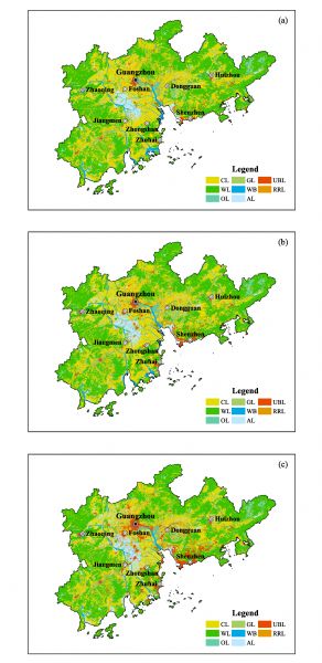
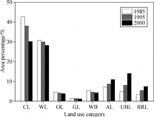
Abstract Urbanization is an irreversible trend worldwide, especially in rapidly developing China. Accelerated urbanization has resulted in rapid urban sprawl and urban landscape pattern changes. Quantifying the spatiotemporal dynamics of urban land use and landscape pattern not only can reveal the characteristics of social transfer and economic development, but also can provide insights into the driving mechanisms of land use changes. In this study, we integrated remote sensing (RS), geographic information system (GIS), landscape metrics, and gradient analysis to quantitatively compare the spatiotemporal dynamics of land use, urban sprawl, and landscape pattern for nine cities in the Pearl River Delta from 1985?2000. For the whole study region, urbanization was obvious. The results show an increase in urban buildup land and shrinkage of cropland in the Pearl River Delta. However, the nine cities differed greatly in terms of the process and magnitude of urban sprawl for both the spatial and temporal dimensions. This was most evident for the cities of Guangzhou and Shenzhen. Gradient analysis on urban landscape changes could deepen understanding of the stages of urban development and provide a scientific foundation for future urban planning and land management strategies in China.
|
| Keywords
urbanization
urban sprawl
landscape pattern
gradient analysis
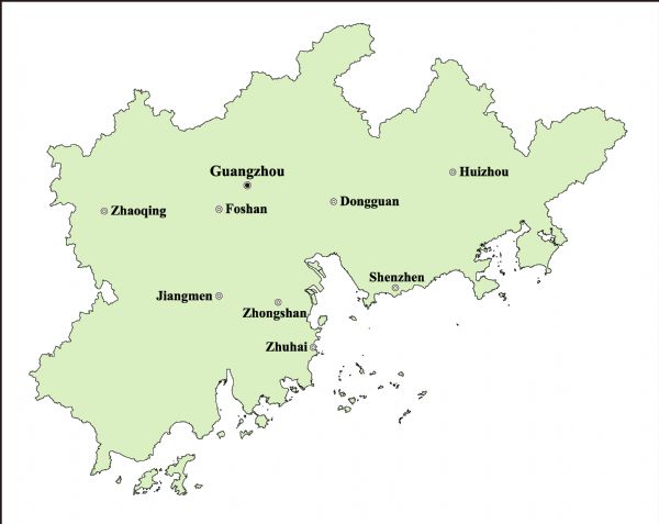
Pearl River Delta in China
|
|
Corresponding Author(s):
Zhuo WU
|
|
Just Accepted Date: 20 March 2017
Online First Date: 19 April 2017
Issue Date: 20 November 2018
|
|
| 1 |
Angel S, Parent J, Civco D L, Blei A, Potere D (2011). The dimensions of global urban expansion: estimates and projections for all countries, 2000‒2050. Prog Plann, 75(2): 53–107
https://doi.org/10.1016/j.progress.2011.04.001
|
| 2 |
Chen M X, Liu W D, Tao X L (2013). Evolution and assessment on China’s urbanization 1960‒2010: under-urbanization or over-urbanization? Habitat Int, 38: 25–33
https://doi.org/10.1016/j.habitatint.2012.09.007
|
| 3 |
Deng J S, Wang K, Hong Y, Qi J G (2009). Spatio-temporal dynamics and evolution of land use change and landscape pattern in response to rapid urbanization. Landsc Urban Plan, 92(3‒4): 187–198
https://doi.org/10.1016/j.landurbplan.2009.05.001
|
| 4 |
Ding C R (2003). Land policy reform in China: assessment and prospects. Land Use Policy, 20(2): 109–120
https://doi.org/10.1016/S0264-8377(02)00073-X
|
| 5 |
Du S Q, Shi P J, Van Rompaey A (2014). The relationship between urban sprawl and farmland displacement in the Pearl River Delta, China. Land (Basel), 3(1): 34–51
https://doi.org/10.3390/land3010034
|
| 6 |
Fan F L, Fan W (2014). Understanding spatial-temporal urban expansion pattern (1990‒2009) using impervious surface data and landscape indexes: a case study in Guangzhou (China). J Appl Remote Sens, 8(1): 083609 doi:10.1117/1.JRS.8.083609
|
| 7 |
Fichera C R, Modica G, Pollino M (2012). Land cover classification and change-detection analysis using multi-temporal remote sensed imagery and landscape metrics. Eur J Remote Sens, 45: 1–18
https://doi.org/10.5721/EuJRS20124501
|
| 8 |
Grimm N B, Faeth S H, Golubiewski N E, Redman C L, Wu J G, Bai X M, Briggs J M (2008). Global change and the ecology of cities. Science, 319(5864): 756–760
https://doi.org/10.1126/science.1150195
|
| 9 |
Haas J, Ban Y F (2014). Urban growth and environmental impacts in Jing-Jin-Ji, the Yangtze, River Delta and the Pearl River Delta. Int J Appl Earth Obs Geoinf, 30: 42–55
https://doi.org/10.1016/j.jag.2013.12.012
|
| 10 |
Hammer R B, Stewart S I, Winkler R L, Radeloff V C, Voss P R (2004). Characterizing dynamic spatial and temporal residential density patterns from 1940‒1990 across the North Central United States. Landsc Urban Plan, 69(2‒3): 183–199
https://doi.org/10.1016/j.landurbplan.2003.08.011
|
| 11 |
Han L J, Zhou W Q, Li W F (2015). Increasing impact of urban fine particles (PM2.5) on areas surrounding Chinese cities. Sci Rep, 5: 12467
https://doi.org/10.1038/srep12467
|
| 12 |
Irwin E G, Bockstael N E (2007). The evolution of urban sprawl: evidence of spatial heterogeneity and increasing land fragmentation. Proc Natl Acad Sci USA, 104(52): 20672–20677
https://doi.org/10.1073/pnas.0705527105
|
| 13 |
Ji W, Ma J, Twibell R W, Underhill K (2006). Characterizing urban sprawl using multi-stage remote sensing images and landscape metrics. Comput Environ Urban Syst, 30(6): 861–879
https://doi.org/10.1016/j.compenvurbsys.2005.09.002
|
| 14 |
Johnson M P (2001). Environmental impacts of urban sprawl: a survey of the literature and proposed research agenda. Environ Plann A, 33(4): 717–735
https://doi.org/10.1068/a3327
|
| 15 |
Li J X, Li C, Zhu F G, Song C H, Wu J G (2013). Spatiotemporal pattern of urbanization in Shanghai, China between 1989 and 2005. Landsc Ecol, 28(8): 1545–1565
https://doi.org/10.1007/s10980-013-9901-1
|
| 16 |
Lin G (2006). Emphases and difficulties in planning of town groups in the Pearl River Delta. Planners, 22(3): 19–21
|
| 17 |
Lin G C S (2001). Metropolitan development in a transitional socialist economy: spatial restructuring in the Pearl River Delta, China. Urban Stud, 38(3): 383–406
https://doi.org/10.1080/00420980120027429
|
| 18 |
Liu H, Weng Q H (2013). Landscape metrics for analysing urbanization-induced land use and land cover changes. Geocarto Int, 28(7): 582–593
https://doi.org/10.1080/10106049.2012.752530
|
| 19 |
Liu J Y, Kuang W H, Zhang Z X, Xu X L, Qin Y W, Ning J, Zhou W C, Zhang S W, Li R D, Yan C Z, Wu S X, Shi X Z, Jiang N, Yu D S, Pan X Z, Chi W F (2014). Spatiotemporal characteristics, patterns, and causes of land-use changes in China since the late 1980s. J Geogr Sci, 24(2): 195–210
https://doi.org/10.1007/s11442-014-1082-6
|
| 20 |
Liu J Y, Liu M L, Zhuang D F, Zhang Z X, Deng X Z (2003). Study on spatial pattern of land-use change in China during 1995‒2000. Sci China Earth Sci, 46(4): 373–384
|
| 21 |
Liu J, Zhan J Y, Deng X Z (2005). Spatio-temporal patterns and driving forces of urban land expansion in China during the economic reform era. Ambio, 34(6): 450–455
https://doi.org/10.1579/0044-7447-34.6.450
|
| 22 |
Long H L, Liu Y S, Wu X Q, Dong G H (2009). Spatio-temporal dynamic patterns of farmland and rural settlements in Su-Xi-Chang region: implications for building a new countryside in coastal China. Land Use Policy, 26(2): 322–333
https://doi.org/10.1016/j.landusepol.2008.04.001
|
| 23 |
Luck M, Wu J G (2002). A gradient analysis of urban landscape pattern: a case study from the Phoenix metropolitan region, Arizona, USA. Landsc Ecol, 17(4): 327–339
https://doi.org/10.1023/A:1020512723753
|
| 24 |
Lv Z Q, Dai F Q, Sun C (2012). Evaluation of urban sprawl and urban landscape pattern in a rapidly developing region. Environ Monit Assess, 184(10): 6437–6448
https://doi.org/10.1007/s10661-011-2431-x
|
| 25 |
McDonnell M J, Hahs A K (2008). The use of gradient analysis studies in advancing our understanding of the ecology of urbanizing landscapes: current status and future directions. Landsc Ecol, 23(10): 1143–1155
https://doi.org/10.1007/s10980-008-9253-4
|
| 26 |
McGarigal K, Cushman S, Neel M, Ene E (2002). FRAGSTATS v3: spatial pattern analysis program for categorical maps. Retrieved July 2016, from
|
| 27 |
McGarigal K, Marks B J (1995). FRAGSTATS: spatial pattern analysis program for quantifying landscape structure. Retrieved July 2016, from
|
| 28 |
National Bureau of Statistics of China (2016). Statistical communique of the people’s republic of China on the 2015 national economic and social development. Retrieved July 2016, from
|
| 29 |
O’Neill R V, Krummel J R, Gardner R H, Sugihara G, Jackson B, DeAngelis D L, Milne B T, Turner M G, Zygmunt B, Christensen S W, Dale V H, Graham R L (1988). Indices of landscape pattern. Landsc Ecol, 1(3): 153–162
https://doi.org/10.1007/BF00162741
|
| 30 |
Qin J, Fang C L, Wang Y, Li G D, Wang S J (2015). Evaluation of three-dimensional urban expansion: a case study of Yangzhou City, Jiangsu Province, China. Chin Geogr Sci, 25(2): 224–236
https://doi.org/10.1007/s11769-014-0728-8
|
| 31 |
Ramachandra T V, Bharath A H, Sowmyashree M V (2015). Monitoring urbanization and its implications in a mega city from space: spatiotemporal patterns and its indicators. J Environ Manage, 148: 67–81
https://doi.org/10.1016/j.jenvman.2014.02.015
|
| 32 |
Sato Y, Yamamoto K (2005). Population concentration, urbanization, and demographic transition. J Urban Econ, 58(1): 45–61
https://doi.org/10.1016/j.jue.2005.01.004
|
| 33 |
Schwarz N (2010). Urban form revisited—Selecting indicators for characterising European cities. Landsc Urban Plan, 96(1): 29–47
https://doi.org/10.1016/j.landurbplan.2010.01.007
|
| 34 |
Seto K C, Fragkias M (2005). Quantifying spatiotemporal patterns of urban land-use change in four cities of China with time series landscape metrics. Landsc Ecol, 20(7): 871–888
https://doi.org/10.1007/s10980-005-5238-8
|
| 35 |
Seto K C, Fragkias M, Güneralp B, Reilly M K (2011). A meta-analysis of global urban land expansion. PLoS One, 6(8): e23777
https://doi.org/10.1371/journal.pone.0023777
|
| 36 |
Seto K C, Güneralp B, Hutyra L R (2012). Global forecasts of urban expansion to 2030 and direct impacts on biodiversity and carbon pools. Proc Natl Acad Sci USA, 109(40): 16083–16088
https://doi.org/10.1073/pnas.1211658109
|
| 37 |
Seto K C, Kaufmann R K (2003). Modeling the drivers of urban land use change in the Pearl River Delta, China: integrating remote sensing with socioeconomic data. Land Econ, 79(1): 106–121
https://doi.org/10.2307/3147108
|
| 38 |
Shi P J, Chen J, Pan Y Z (2000). Land use change mechanism in Shenzhen city. Acta Geogr Sin, 55(2): 151–160
|
| 39 |
Statistics Bureau of Guangdong Province (2014). Guangdong Statistical Yearbook 2013. Beijing: China Statistics Press
|
| 40 |
The Pearl River Delta Region Planning (2014). Retrieved October 2016, from
|
| 41 |
Tian G J, Wu J G, Yang Z F (2010). Spatial pattern of urban functions in the Beijing metropolitan region. Habitat Int, 34(2): 249–255
https://doi.org/10.1016/j.habitatint.2009.09.010
|
| 42 |
United Nations (2014). World urbanization prospects: the 2014 revision, Highlights. (ST/ESA/SER.A/352). Retrieved July 2016, from
|
| 43 |
Wang Y P, Wang Y L, Wu J S (2009). Urbanization and informal development in China: urban villages in Shenzhen. Int J Urban Reg Res, 33(4): 957–973
https://doi.org/10.1111/j.1468-2427.2009.00891.x
|
| 44 |
Wu J G (2004). Effects of changing scale on landscape pattern analysis: scaling relations. Landsc Ecol, 19(2): 125–138
https://doi.org/10.1023/B:LAND.0000021711.40074.ae
|
| 45 |
Wu W J, Zhao S Q, Zhu C, Jiang J L (2015). A comparative study of urban expansion in Beijing, Tianjin and Shijiazhuang over the past three decades. Landsc Urban Plan, 134: 93–106
https://doi.org/10.1016/j.landurbplan.2014.10.010
|
| 46 |
Xiao J Y, Shen Y J, Ge J F, Tateishi R, Tang C Y, Liang Y Q, Huang Z Y (2006). Evaluating urban expansion and land use change in Shijiazhuang, China, by using GIS and remote sensing. Landsc Urban Plan, 75(1‒2): 69–80
https://doi.org/10.1016/j.landurbplan.2004.12.005
|
| 47 |
Xu J Y, Zhang Z X, Zhao X L, Liu B, Yi L (2015). Spatial-temporal characteristics and driving forces of urban sprawl for major cities of the Pearl River Delta region in recent 40 years. Acta Scientiarum Naturalium Univerisitatis Pekinensis, 51(6): 1119–1131
|
| 48 |
Xu X L, Min X B (2013). Quantifying spatiotemporal patterns of urban expansion in China using remote sensing data. Cities, 35: 104–113
https://doi.org/10.1016/j.cities.2013.05.002
|
| 49 |
Xu X Q, Li X (2009). Research on the urbanization of Pearl River Delta (1978‒2008): review and preview. Human Geogr, 24(1): 1–6
|
| 50 |
Yang X J (2013). China’s rapid urbanization. Science, 342(6156): 310
https://doi.org/10.1126/science.342.6156.310-a
|
| 51 |
Yeh A G O, Li X (1999). Economic development and agricultural land loss in the Pearl River Delta, China. Habitat Int, 23(3): 373–390
https://doi.org/10.1016/S0197-3975(99)00013-2
|
| 52 |
Yu X J, Ng C N (2007). Spatial and temporal dynamics of urban sprawl along two urban–rural transects: a case study of Guangzhou, China. Landsc Urban Plan, 79(1): 96–109
https://doi.org/10.1016/j.landurbplan.2006.03.008
|
| 53 |
Zhang T (2000). Land market forces and government’s role in sprawl: the case of China. Cities, 17(2): 123–135
https://doi.org/10.1016/S0264-2751(00)00007-X
|
|
Viewed |
|
|
|
Full text
|
|
|
|
|
Abstract
|
|
|
|
|
Cited |
|
|
|
|
| |
Shared |
|
|
|
|
| |
Discussed |
|
|
|
|