|
|
|
UAV-based spatial pattern of three-dimensional green volume and its influencing factors in Lingang New City in Shanghai, China |
Sijun ZHENG1,2, Chen MENG3,4, Jianhui XUE1( ), Yongbo WU1, Jing LIANG2, Liang XIN5, Lang ZHANG2 ), Yongbo WU1, Jing LIANG2, Liang XIN5, Lang ZHANG2 |
1. College of Biology and the Environment, Nanjing Forestry University, Nanjing 210037, China
2. Shanghai Academy of Landscape Architecture Science and Planning, Shanghai 200241, China
3. School of Ecological and Environmental Sciences, East China Normal University, Shanghai 200241, China
4. Shanghai Key Laboratory for Urban Ecological Processes and Eco-Restoration, Shanghai 200241, China
5. Shanghai Institute of Surveying and Mapping, Shanghai 200063, China |
|
|
|
|
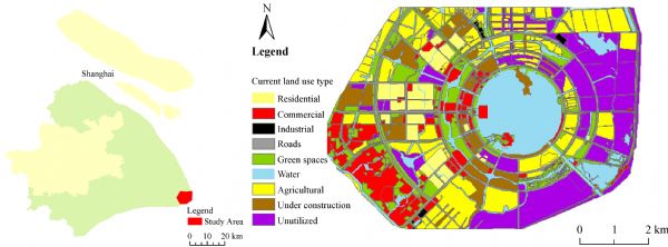
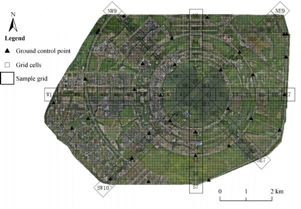
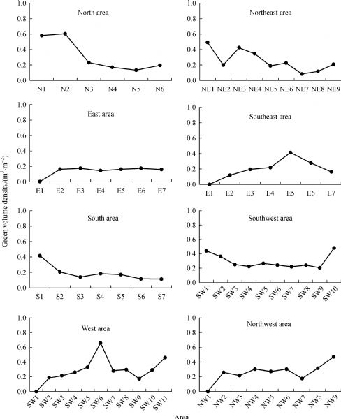
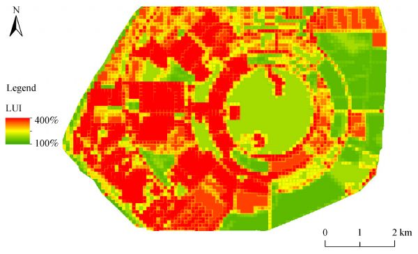
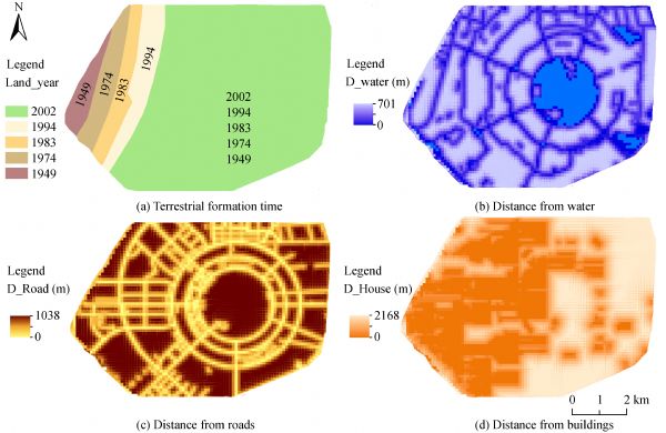
Abstract Three-dimensional green volume (TDGV) reflects the quality and quantity of urban green space and its provision of ecosystem services; therefore, its spatial pattern and the underlying influential factors play important roles in urban planning and management. However, little is known about the factors contributing to the spatial pattern of TDGV. In this paper, TDGV and land use intensity (LUI) extracted from high spatial resolution (0.05 m) remotely sensed data acquired by an unmanned aerial vehicle (UAV), anthropogenic factors and natural factors were utilized to identify the spatial pattern of TDGV and the potential influencing factors in Lingang New City, a rapidly developed coastal town in Shanghai. The results showed that most of the TDGV was distributed in the western part of this new city and that its spatial variations were significantly axial. TDGV corresponded well with the chronologies of land formation, urban planning, and construction in the city. Generalized least squares (GLS) analysis of TDGV (grid cell size: 100 × 100 m) and its influencing factors showed that the TDGV in this new city was significantly negatively correlated with both LUI and distance from roads and significantly positively correlated with land formation time and distance from water. Distance from buildings did not affect TDGV. Additionally, the degree of influence decreased in the following order: distance from water>land formation time>distance from roads>LUI. These results indicate that the spatial pattern of TDGV in this new town was mainly affected by natural factors (i.e., the distance from water and land formation time) and that the artificial disturbances caused by rapid urbanization did not decrease the regional TDGV. The main factors shaping the spatial distribution of TDGV in this city were local natural factors. Our findings suggest that the improvement in local soil and water conditions should be emphasized in the construction of new cities in coastal areas to ensure the efficient provision of ecological services by urban green spaces.
|
| Keywords
low-altitude remote sensing
LUI
urban space layout
land formation time
dominant factor
|
|
Corresponding Author(s):
Jianhui XUE
|
|
Online First Date: 23 September 2021
Issue Date: 17 January 2022
|
|
| 1 |
K Anderson, S Hancock, S Casalegno, A Griffiths, D Griffiths, F Sargent, J McCallum, D T C Cox, K J Gaston (2018). Visualising the urban green volume: exploring LiDAR voxels with tangible technologies and virtual models. Landsc Urban Plan, 178: 248–260
https://doi.org/10.1016/j.landurbplan.2018.05.024
|
| 2 |
S Casalegno, K Anderson, D T C Cox, S Hancock, K J Gaston (2017). Ecological connectivity in the three-dimensional urban green volume using waveform airborne lidar. Sci Rep, 7(1): 45571
https://doi.org/10.1038/srep45571
pmid: 28382936
|
| 3 |
M Çetin (2016). Sustainability of urban coastal area management: a case study on Cide. J Sustain For, 35(7): 527–541
https://doi.org/10.1080/10549811.2016.1228072
|
| 4 |
P Chen, Y Chu, F X Gu, Y D Zhang, X L Pan (2003). Spatial heterogeneity analysis of vegetation and soil characteristics in oasis-desert transition zone landscape. J Appl Ecol, 14(6): 904–908 (in Chinese)
pmid: 12973993
|
| 5 |
B T Chunwate, S Yahaya, I K Samaila, S W Ja’afaru (2019). Analysis of urban land use and land cover change for sustainable development: a case of Lafia, Nasarawa State, Nigeria. J Geogr Inf Syst, 11(03): 347–358
https://doi.org/10.4236/jgis.2019.113021
|
| 6 |
G Xenakis, D Ray, M Maurizio (2012). Effects of climate and site characteristics on Scots pine growth. Eur J For Res, 131(2): 427–439
https://doi.org/10.1007/s10342-011-0516-2
|
| 7 |
M Fahmy, M Mahdy, S Mahmoud, M Abdelalim, S Ezzeldin, S Attia (2020). Influence of urban canopy green coverage and future climate change scenarios on energy consumption of new sub-urban residential developments using coupled simulation techniques: a case study in Alexandria, Egypt. Energy Rep, 6(1): 638–645
https://doi.org/10.1016/j.egyr.2019.09.042
|
| 8 |
W Fu, S Liu, S D Degloria, S Dong, R Beazley (2010). Characterizing the “frag-mentation–barrier” effect of road networks on landscape connectivity: a case study in Xishuangbanna, southwest China. Landsc Urban Plan, 95(3): 122–129
https://doi.org/10.1016/j.landurbplan.2009.12.009
|
| 9 |
Z Q Gao, X Y Liu, J C Ning, Q S Lu (2014). Remote sensing based on the change and genesis of China’s coastline and reclamation area in the past 30 years. Trans Chinese Soc Agr Eng, 30(12): 140–147 (in Chinese)
|
| 10 |
Z Q Gao, J Y Liu, D F Zhuang (1999). Research on land use/land cover in China based on remote sensing and GIS. National Remote Sens Bull, 3(2): 134–138 (in Chinese)
|
| 11 |
J Z Gong, B C Xia (2006). Internal structure and temporal and spatial variation of vegetation coverage in Guangzhou based on remote sensing images. J Plant Res Environ, 15(4): 25–29 (in Chinese)
|
| 12 |
D R Grafius, R Corstanje, P H Warren, K L Evans, S Hancock, J A Harris (2016). The impact of land use/land cover scale on modelling urban ecosystem services. Landsc Ecol, 31(7): 1509–1522
https://doi.org/10.1007/s10980-015-0337-7
|
| 13 |
J W Gregg, C G Jones, T E Dawson (2003). Urbanization effects on tree growth in the vicinity of New York City. Nature, 424(6945): 183–187
https://doi.org/10.1038/nature01728
pmid: 12853954
|
| 14 |
Z L Han, Q Q Meng, X L Yan, W Z Zhao (2020). Spatial-temporal relationship between land use intensity and ecosystem Service value in northern Liaodong Bay in recent 30 years. Acta Ecol Sin, 2020,40 (08): 1–12 (in Chinese)
|
| 15 |
L S He, C Zhang (2019). Influence factor analysis of Yunnan pine forest accumulation. J Southwest For U (Natural Sciences), 39(6): 116–122 (in Chinese)
|
| 16 |
W Li, B Q Jia, C Wang (2008). Research status and prospect of three dimensional green quantity of urban forest. World For Res, 21(4): 31–34 (in Chinese)
|
| 17 |
W J Li, Q S Yu (2013). Summary of history, present situation and management policy of reclamation in China. China Territory Today, (01): 36–38 (in Chinese)
|
| 18 |
Y Li, Z Shi, H M Jin, H Y Li, R C Wang (2006). Spatial variation and dynamic change of soil characteristics in reclamation area of sea floor. Bull Sci Tech, 22(6): 827–833 (in Chinese)
|
| 19 |
C Liu, Z G Liu (2011). Three-dimensional green planning analysis of Harbin urban forest based on AHP. J Northeast For U, 39(4): 52–55,129 (in Chinese)
|
| 20 |
C Liu, P Xu, J Ma (2012). Low carbon planning and target management of Shanghai Lingang New City Center. City Plan Rev, 36(12): 52–59 (in Chinese)
|
| 21 |
L B Ma, X Y Li, W J Cheng (2019). Spatial and temporal difference identification of land use intensity and its influencing factors based on irrigated area panel data. Chinese J Ecol, 38(3): 908–918 (in Chinese)
|
| 22 |
A N M Nor, R Corstanje, J A Harris, T Brewer (2017). Impact of rapid urban expansion on green space structure. Ecol Indic, 81: 274–284
https://doi.org/10.1016/j.ecolind.2017.05.031
|
| 23 |
B L Ong (2003). Green plot ratio: an ecological measure for architecture and urban planning. Landsc Urban Plan, 63(4): 197–211
https://doi.org/10.1016/S0169-2046(02)00191-3
|
| 24 |
Shanghai Urban Planning and Design Reasearch Institute (2009). Overall planning of Lingang New City. Shanghai Urban Plan Rev, (04): 11–26 (in Chinese)
|
| 25 |
Q Sun (2011). Exploration and practice of low-carbon city planning of Lingang New City. Shanghai Urban Plan Rev, (05): 24–29 (in Chinese)
|
| 26 |
G Wang, S Liao (2006). Spatial heterogeneity of land use intensity change. J Appl Ecol, 17(4): 611–614 (in Chinese)
pmid: 16836088
|
| 27 |
X H Xiong, Z Y Dai (2017). Correlation analysis between ecological services and land use intensity in Fenghua City. Geospat Inform, 15(4): 102–104 (in Chinese)
|
| 28 |
İpek Yaralioğlu, Ozge Ozden (2019). Sustainable development of urban coastal area in urban planning
https://doi.org/10.13140/RG.2.2.18014.08004
|
| 29 |
L Zhang, Y Chen, S T Wang, M X Men, H M Xu (2015). Assessment and early warning of land ecological security in rapidly urbanizing coastal area: a case study of Caofeidian new district, Hebei, China. J Appl Ecol, 26(08): 2445–2454 (in Chinese)
pmid: 26685609
|
| 30 |
Q Zhang, X H Cui, L Xia, Y Zhu, Q F Zhang (2008). Vegetation and soil characteristics in the embankment area of Lingang New City in Shanghai in the past 60 years. J Zhejiang For College, 25(06): 698–704 (in Chinese)
|
| 31 |
J H Zhou (2001). Urban green quantity measurement model and information system. Acta Geogr Sin, 56(1): 14–23 (in Chinese)
|
| 32 |
J H Zhou, Y Huang, B L Yu (2015). Mapping vegetation-covered urban surfaces using seeded region growing in Visible-NIR Air Photos. IEEE J-STARS, 8(5): 2212–2221
https://doi.org/10.1109/JSTARS.2014.2362308
|
| 33 |
J H Zhou, J Qin, K Gao, H B Leng (2016). SVM-based soft classification of urban tree species using very high-spatial resolution remote-sensing imagery. Int J Remote Sens, 37(11): 2541–2559
https://doi.org/10.1080/01431161.2016.1178867
|
| 34 |
S M Zhu, J Hou, C H Hu, Y S Ding (2013). Analysis of dynamic Changes of landscape Pattern of Shanghai New Port City. Geospat inform, 11(06): 106–108+11 (in Chinese)
|
| 35 |
T G Zhou, H X Luo, D Z Guo (2005). Quantitative research on three-dimensional green quantity of urban space based on remote sensing image. Chinese J Ecol, 25(03): 415–420 (in Chinese)
|
| 36 |
Y F Zhou, J H Zhou (2001). Evaluation system of urban ecological environment based on three-dimensional greening quantity. Chinese Landsc Architecture, 17(5): 77–79 (in Chinese)
|
| 37 |
Y F Zhou, J H Zhou (2006). Green quantity rapid measurement model. Acta Ecol Sin, 26(12): 4204–4211 (in Chinese)
|
|
Viewed |
|
|
|
Full text
|
|
|
|
|
Abstract
|
|
|
|
|
Cited |
|
|
|
|
| |
Shared |
|
|
|
|
| |
Discussed |
|
|
|
|