Please wait a minute...
Frontiers of Earth Science

ISSN 2095-0195

ISSN 2095-0209(Online)

CN 11-5982/P

Postal Subscription Code 80-963

2018 Impact Factor: 1.205

Front. Earth Sci.    2020, Vol. 14 Issue (3) : 493-511    https://doi.org/10.1007/s11707-019-0758-8
RESEARCH ARTICLE
Computational investigation on hydrodynamic and sediment transport responses influenced by reclamation projects in the Meizhou Bay, China
Gefei DENG2, Yongming SHEN1,2(), Changping LI3, Jun TANG2
1. Institute of Environmental and Ecological Engineering, Guangdong University of Technology, Guangzhou 510006, China
2. State Key Laboratory of Coastal and Offshore Engineering, Dalian University of Technology, Dalian 116024, China
3. Research Center for Eco-Environmental Engineering, Dongguan University of Technology, Dongguan 523808, China
 Download: PDF(4326 KB)   HTML
 Export: BibTeX | EndNote | Reference Manager | ProCite | RefWorks
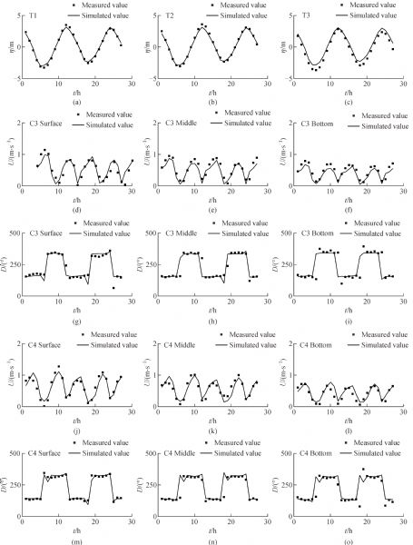
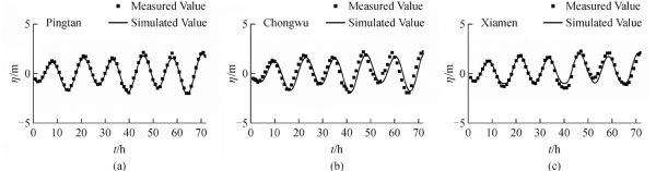
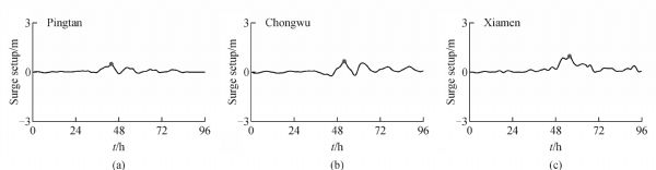
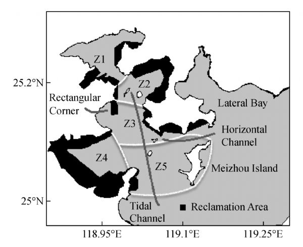
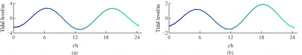
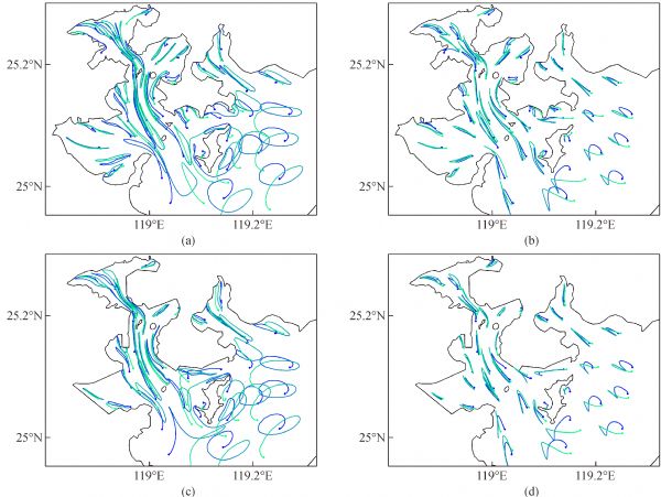
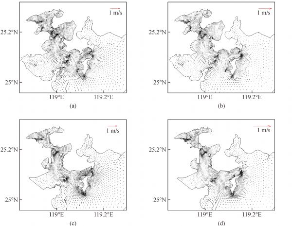
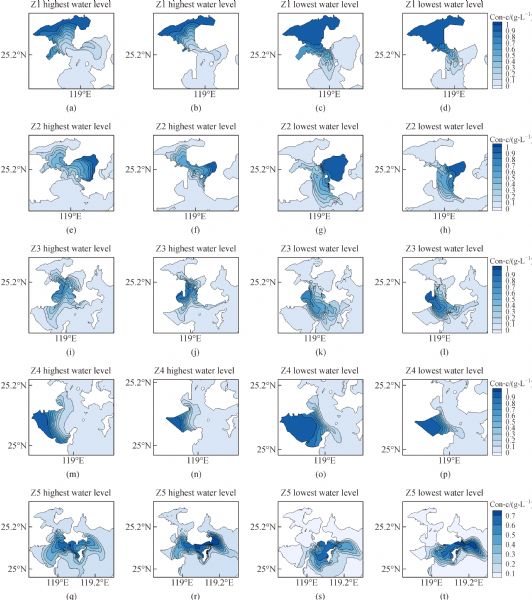
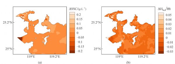
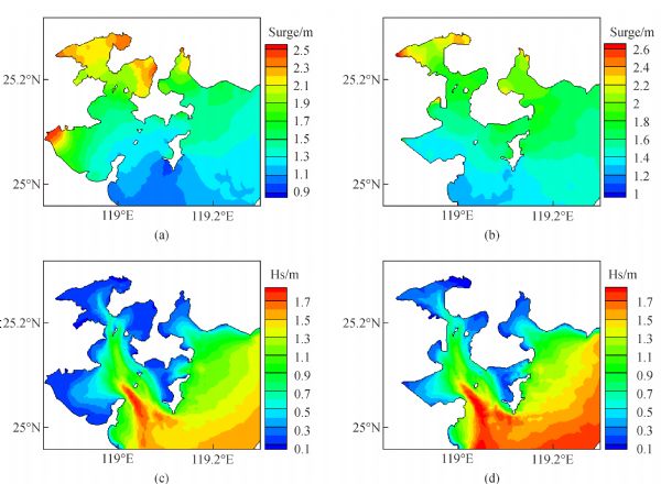
Abstract

Reclamation projects are the main method of coastal exploitation, and the hydrodynamic environmental effect, together with the sediment transport response of the reclamation project, is important to the project’s site selection and environmental protection. Herein, a 3D numerical model based on the finite volume community ocean model (FVCOM) is applied to simulate the changes in the Meizhou Bay’s hydrodynamic environment and sediment transport after a reclamation project. The reclamation project greatly alters the shape of the shoreline and narrows the bay, leading to a significant change in its hydrodynamic environment and sediment transport. After the project, the clockwise coastal residual current in the corner above the Meizhou Island gradually disappears. An obvious counter-clockwise coastal residual current emerges around the rectangular corner. The tidal prism decreases by 0.65 × 10⁹ and 0.44 × 10⁹ m3 in the spring and neap tides, respectively. The residence time presents a major increase. These changes lead to the weakening of the water exchange capacity and the reduction of the self-purification capacity of the bay. Currents in the tidal channel weaken, whilst currents in the horizontal channel strengthen. The strength and scope of particle trajectories around the horizontal channel and the Meizhou Island enhance. The suspended sediment concentration (SSC) increases in the majority of the Meizhou Bay but decreases in the lateral bay. The eastern corner of Z2 shows a tendency to erode. The western region of the Meizhou Island, the upper portion of the rectangular corner and the western corner of Z4 show a tendency to deposit. The reclamation project increases the maximum storm surges by 0.06 m and decreases the maximum significant wave heights by 0.09 m.

Keywords Meizhou Bay      FVCOM+SWAN      reclamation project      hydrodynamic environment      SSC      typhoon     
Corresponding Author(s): Yongming SHEN   
Just Accepted Date: 06 June 2019   Online First Date: 14 November 2019    Issue Date: 04 December 2020
 Cite this article:   
Gefei DENG,Yongming SHEN,Changping LI, et al. Computational investigation on hydrodynamic and sediment transport responses influenced by reclamation projects in the Meizhou Bay, China[J]. Front. Earth Sci., 2020, 14(3): 493-511.
 URL:  
https://academic.hep.com.cn/fesci/EN/10.1007/s11707-019-0758-8
https://academic.hep.com.cn/fesci/EN/Y2020/V14/I3/493
Fig.1  The topography in the Meizhou Bay.
Fig.2  Triangular mesh of the larger model.
Fig.3  Verifications of tidal level at various stations. (a) Meizhou 2005; (b) Shantou 2005.
Fig.4  Verifications of monthly average salinity (a, b, c) and temperature at various stations (d, e, f).
Station Longitude Latitude M2 S2 K1 O1
H/m g/(° ) H/m g/(° ) H/m g/(° ) H/m g/(° )
Nanao 117.02°E 23.47°N −0.13 −0.98 0.00 −57.56 −0.06 12.79 0.00 8.19
Dongshan 117.57°E 23.75°N 0.01 7.86 0.15 −2.97 −0.05 9.72 0.00 3.81
Futouwan 117.87°E 23.92°N 0.12 0.71 0.26 −0.81 −0.02 3.41 0.02 4.49
Jinmen 118.17°E 24.38°N 0.01 25.38 0.21 0.81 −0.02 0.62 0.01 6.56
Weitou 118.57°E 24.53°N −0.23 14.32 0.05 −7.46 −0.09 −8.02 −0.06 −1.33
Jiangjunao 119.52°E 23.37°N −0.05 19.69 0.06 0.83 −0.01 −2.83 0.01 3.45
Magong 119.55°E 23.55°N −0.05 17.94 0.18 0.30 0.00 −3.05 0.02 0.61
Xinhuawan 119.58°E 25.33°N 0.02 22.57 0.09 −6.93 −0.05 −1.49 −0.02 0.90
Baishadao 119.60°E 23.73°N −0.03 17.31 0.17 1.76 −0.01 −3.62 0.01 0.60
Kouhu 120.17°E 23.70°N −0.02 20.73 0.11 −7.28 0.02 −7.26 0.03 −5.79
Gaoxiong 120.27°E 22.62°N 0.04 −9.07 0.02 −0.44 −0.04 −6.99 0.00 −9.83
Taizhong 120.55°E 24.33°N 0.06 15.50 0.15 −10.24 0.01 −2.79 0.01 −21.02
Checheng 120.68°E 22.07°N −0.01 2.08 0.02 28.27 −0.02 −7.69 0.01 0.09
Houlong 120.75°E 24.62°N 0.00 10.46 0.09 −19.27 0.00 −4.40 0.01 5.89
Chongwu 118.95°E 24.88°N 0.01 3.43 0.18 5.06 −0.03 −3.56 0.00 4.19
Pingtan 119.83°E 25.47°N −0.03 1.21 0.10 −24.26 −0.05 −9.69 −0.01 −1.54
Jinjiang 118.67°E 24.63°N 0.10 4.39 0.20 −11.23 −0.03 0.36 0.01 12.46
Maximum absolute error 0.23 25.38 0.26 57.56 0.09 12.79 0.06 21.02
Tab.1  Error of the amplitude and phase of the M2, S2, K1and O1 at some stations between the simulated and the published value
Fig.5  Distributions of simulated temperature and salinity around the Meizhou Bay and the Xiamen Bay in the larger model. (a) Temperature distribution in summer; (b) temperature distribution in winter; (c) salinity distribution in summer; (d) salinity distribution in winter.
Fig.6  The high resolution grid within the Meizhou Bay.
Fig.7  Verifications of tidal level and current at various stations.
Fig.8  Verifications of temperature (a,b,c) and salinity (d, e, f) at C3 station.
Fig.9  Verifications of SSC at various stations.
Fig.10  The average SSC distribution in (a) the spring tide and in (b) the neap tide.
Time Central Location Central Pressure /hPa Maximum Wind Speed /(m·s−1)
Longitude Latitude
2010/9/19 0:00 123.7°E 23.9°N 935 52
2010/9/19 6:00 122.3°E 24.0°N 935 52
2010/9/19 12:00 121.0°E 23.2°N 950 45
2010/9/19 18:00 120.0°E 23.1°N 970 35
2010/9/20 0:00 119.3°E 23.5°N 970 35
2010/9/20 6:00 118.1°E 23.8°N 970 35
Tab.2  Information of Typhoon Fanapi (1011) obtained from the Chinese typhoon weather website
Fig.11  Verifications of water level at various stations during Typhoon Fanapi.
Fig.12  The development of storm surges at various stations.
Fig.13  Sketch map of the reclamation project and the location of feature positions.
Fig.14  The tidal level curve of (a) the typical spring tide and (b) the typical neap tide.
Fig.15  Particle trajectory within the Meizhou Bay before and after the reclamation project during the spring and neap tides.
Fig.16  Residual current within the Meizhou Bay before and after the reclamation project during the spring and neap tides. (a) Residual current during spring tide before reclamation; (b) residual current during neap tide before reclamation; (c) residual current during spring tide after reclamation; (d) residual current during neap tide after reclamation.
Fig.17  Tracer’s concentration in five zones at the highest and lowest water level before and after the reclamation project. The first column: at the highest water level before the project. The second column: at the highest water level after the project. The third column: at the lowest water level before the project. The forth column: at the lowest water level after the project.
Reclamation Sea area/km2 Spring tide Neap tide
Tidal prism
/(109 m3)
Change
/(109 m3)
Change rate Tidal prism
/(109 m3)
Change
/(109 m3)
Change rate
Before 1014.30 5.46 3.31
After 876.98 4.81 −0.65 −13.61% 2.87 −0.44 −15.49%
Tab.3  Statistics and comparison of tidal prism within the Meizhou Bay
Zone Reclamation Spring tide Neap tide
Amplitude
/day
Change
/day
Change rate Amplitude
/day
Change
/day
Change rate
Z1 Before 14.65 30
After 30 15.35 104.78% 30
Z2 Before 16.97 14.12
After 19.67 2.70 15.91% 15.50 1.38 9.77%
Z3 Before 8.47 12.85
After 16.18 7.71 91.03% 24.53 11.68 90.89%
Z4 Before 22.72 23.72
After 30 7.28 32.04% 30 6.28 26.48%
Z5 Before 8.52 9.31
After 9.73 1.21 14.20% 10.62 1.31 14.07%
Tab.4  Statistics and comparison of residence time in five zones within the Meizhou Bay
Fig.18  The characteristic of sediment transportation in the Meizhou Bay. (a) Distribution of the difference of the average SSC. (b) Sketch map of seabed deformation. Both of them are obtained by subtracting the interested variables (SSC and seabed height) in the original situation from the corresponding variables in the reclamation situation.
Fig.19  The distribution of maximum storm surges and significant wave heights around the Meizhou Bay. (a) Distribution of maximum storm surges before project. (b) Distribution of maximum storm surges after project. (c) Distribution of maximum significant wave heights before project. (d) Distribution of maximum significant wave heights after project.
Reclamation Maximum storm surges Maximum significant wave heights
Amplitude/m Change/m Change rate Amplitude/m Change/m Change rate
Before 2.55 1.91
After 2.61 0.06 2.35% 1.82 −0.09 −4.71%
Tab.5  Statistics and comparison of maximum storm surges and significant wave heights within the Meizhou Bay
1 J C Chen (1988). A primary study on sedimental resource in Meizhou Bay. J Fujian Normal U (Natural Science), 4(3): 104–111
2 C Chen, H Liu, R C Beardsley (2003). An unstructured, finite-volume, three-dimensional, primitive equation ocean model: application to coastal ocean and estuaries. J Atmos Ocean Technol, 20(1): 159–186
https://doi.org/10.1175/1520-0426(2003)020<0159:AUGFVT>2.0.CO;2
3 C Chen, H Huang, R C Beardsley, H Liu, Q Xu, G Cowles (2007). A finite volume numerical approach for coastal ocean circulation studies: comparisons with finite difference models. J Geophys Res, 112(C3): C03018
https://doi.org/10.1029/2006JC003485
4 W B Chen, W C Liu, M H Hsu (2012). Computational investigation of typhoon-induced storm surges along the coast of Taiwan. Nat Hazards, 64(2): 1161–1185
https://doi.org/10.1007/s11069-012-0287-1
5 T Fujita (1952). Pressure distribution within typhoon. Geophys Mag, 23(4): 437–451
6 Y K Guo, J S Zhang, L X Zhang, Y M Shen (2009). Computational investigation of typhoon-induced storm surge in Hangzhou Bay, China. Estuar Coast Shelf Sci, 85(4): 530–536
https://doi.org/10.1016/j.ecss.2009.09.021
7 Y K Guo, X G Wu, C H Pan, J S Zhang (2012). Numerical Simulation of the Tidal Flow and Suspended Sediment Transport in the Qiantang Estuary. J Waterw Port Coast Ocean Eng, 138(3): 192–202
https://doi.org/10.1061/(ASCE)WW.1943-5460.0000118
8 X F Guo, C Wang, C H Chen, J J Tang (2014). Numerical simulation of the transport diffusion of suspended matter during the construction of Fengwei reclamation project at Meizhou Bay. J Appl Oceanography, 33(1): 125–132 (in Chinese)
9 K Hasselmann, T P Barnett, E Bouws, H Carlson, D E Cartwright, K Enke, J A Ewing, H Gienapp, D E Hasselmann, P Kruseman, A Meerburg, P Müller, D J Olbers, K Richter, W Sell, H Walden (1973). Measurements of Wind-Wave Growth and Swell Decay during the Joint North Sea Wave Project (JONSWAP). Deutches Hydrographisches Institut
10 G J Holland (1980). An analytic model of the wind and pressure profiles in hurricanes. Mon Weather Rev, 108(8): 1212–1218
https://doi.org/10.1175/1520-0493(1980)108<1212:AAMOTW>2.0.CO;2
11 G J Holland (2008). A revised hurricane and pressure-wind model. Mon Weather Rev, 136(9): 3432–3445
https://doi.org/10.1175/2008MWR2395.1
12 Q Z Hou, L Q Zuo, Y J Lu, Z L Wang, S P Mo, X J She (2017). Hydrodynamic environment response to human interventions in a Macro Tidal Bay: the example of the Quanzhou Bay. J Basic Sci Eng S, 25(6): 1124–1138 (in Chinese)
13 C P Jelesnianski (1965). A Numerical calculation of storm surges induced by a tropical storm impinging on a Continental shelf. Mon Weather Rev, 93(6): 343–358
https://doi.org/10.1175/1520-0493(1993)093<0343:ANCOS>2.3.CO;2
14 H Jia, Y M Shen, M R Su, C X Yu (2018). Numerical simulation of hydrodynamic and water quality effects of shoreline changes in Bohai Bay. Front Earth Sci, 12(3): 625–639
https://doi.org/10.1007/s11707-018-0688-x
15 X H Liu, W R Huang (2009). Modeling sediment resuspension and transport induced by storm wind in Apalachicola Bay, USA. Environ Model Softw, 24(11): 1302–1313
https://doi.org/10.1016/j.envsoft.2009.04.006
16 H Liu, W R Pan, Z B Luo, X F Shi (2009). Numerical study on the tidal regime in Meizhou Bay. J Oceanogr Taiwan, 28: 118–122 (in Chinese)
17 Z B Luo, W R Pan, G R Zhang (2007). The sediment properties and transportation rules of the Xiuyu Sea-route in Meizhou Bay. J Xiamen U Natural S, 46(3): 382–385
18 V A Myers (1957). Maximum hurricane winds. Bull Am Meteorol Soc, 38(4): 227–228
19 G L Mellor, T Yamada (1982). Development of a turbulence closure model for geophysical fluid problems. Rev Geophys Space Phys, 20(4): 851–875
https://doi.org/10.1029/RG020i004p00851
20 H E Pelling, J A Mattias Green (2013). Sea level rise and tidal power plants in the Gulf of Maine. J Geophys Res Oceans, 118(6): 2863–2873
https://doi.org/10.1002/jgrc.20221
21 Y M Shen, H Jia, C P Li, J Tang (2018). Numerical simulation of saltwater intrusion and storm surge effects of reclamation in Pearl River Estuary, China. Appl Ocean Res, 79: 101–112
https://doi.org/10.1016/j.apor.2018.07.013
22 P J Vickery, P F Skerlj, A C Steckley, L A Twisdale (2000). Hurricane wind field model for use in hurricane simulations. J Struct Eng, 126(10): 1203–1221
https://doi.org/10.1061/(ASCE)0733-9445(2000)126:10(1203)
23 H E Willoughby, M E Rahn (2004). Parametric representation of the primary hurricane vortex. Part I: Observations and evaluation of the Holland (1980) model. Mon Weather Rev, 132(12): 3033–3048
https://doi.org/10.1175/MWR2831.1
24 Y Xu, D W Chen, L Li, P L Li (2015). Numerical modeling of strom surge in Taiwan Strait caused by Typhoon FANAPI. Periodical Ocean U C, 45(2): 008–017 (in Chinese)
25 Z C Zhu, Z J Hu, Y Q Zhang, W Q Chi, J Q Liu, S H Bian, C B Xiong (2014). Numerical simulation and observations of vertical non-uniform of water temperature in the Meizhou Bay influenced by warm water discharge. Adv Marine Sci, 32(2): 230–238 (in Chinese)
[1] Md. Rezuanul ISLAM, Hiroshi TAKAGI. Typhoon parameter sensitivity of storm surge in the semi-enclosed Tokyo Bay[J]. Front. Earth Sci., 2020, 14(3): 553-567.
[2] Xiba TANG, Fan PING, Shuai YANG, Mengxia LI, Jing PENG. On the rapid intensification for Typhoon Meranti (2016): convection, warm core, and heating budget[J]. Front. Earth Sci., 2019, 13(4): 791-807.
[3] Linna ZHAO, Xuemei BAI, Dan QI, Cheng XING. BMA probability quantitative precipitation forecasting of land-falling typhoons in south-east China[J]. Front. Earth Sci., 2019, 13(4): 758-777.
[4] Jia ZHU, Jiong SHU, Xing YU. Improvement of typhoon rainfall prediction based on optimization of the Kain-Fritsch convection parameterization scheme using a micro-genetic algorithm[J]. Front. Earth Sci., 2019, 13(4): 721-732.
[5] Wanben WU, Wei WANG, Michael E. Meadows, Xinfeng YAO, Wei PENG. Cloud-based typhoon-derived paddy rice flooding and lodging detection using multi-temporal Sentinel-1&2[J]. Front. Earth Sci., 2019, 13(4): 682-694.
[6] Baofeng JIAO, Lingkun RAN, Xinyong SHEN. The evolution of hollow symmetric-PV tower during the landfall of Typhoon Mujigae (2015)[J]. Front. Earth Sci., 2019, 13(4): 817-828.
[7] Sui HUANG, Shengming TANG, Hui YU, Wenbo XUE, Pingzhi FANG, Peiyan CHEN. Impact of physical representations in CALMET on the simulated wind field over land during Super Typhoon Meranti (2016)[J]. Front. Earth Sci., 2019, 13(4): 744-757.
[8] Zhoujie CHENG, Ming WEI, Yaping ZHU, Jie BAI, Xiaoguang SUN, Li GAO. Cloud type identification for a landfalling typhoon based on millimeter-wave radar range-height-indicator data[J]. Front. Earth Sci., 2019, 13(4): 829-835.
[9] Yongming SHEN, Gefei DENG, Zhihao XU, Jun TANG. Effects of sea level rise on storm surge and waves within the Yangtze River Estuary[J]. Front. Earth Sci., 2019, 13(2): 303-316.
[10] Yan-An LIU, Zhibin SUN, Maosi CHEN, Hung-Lung Allen HUANG, Wei GAO. Assimilation of atmospheric infrared sounder radiances with WRF-GSI for improving typhoon forecast[J]. Front. Earth Sci., 2018, 12(3): 457-467.
[11] Lei HUANG, Hui ZHAO, Jiayi PAN, Adam DEVLIN. Remote sensing observations of phytoplankton increases triggered by successive typhoons[J]. Front. Earth Sci., 2017, 11(4): 601-608.
[12] Liangxia ZHANG, Wei CAO, Jiangwen FAN. Soil organic carbon dynamics in Xilingol grassland of northern China induced by the Beijing-Tianjin Sand Source Control Program[J]. Front. Earth Sci., 2017, 11(2): 407-415.
[13] Qikun ZHOU,Guanghai HU,Yongfu SUN,Xiaohui LIU,Yupeng SONG,Lifeng DONG,Changming DONG. Numerical research on evolvement of submarine sand waves in the Northern South China Sea[J]. Front. Earth Sci., 2017, 11(1): 35-45.
[14] Juan LI,Xiaolei ZOU. Impact of FY-3A MWTS radiances on prediction in GRAPES with comparison of two quality control schemes[J]. Front. Earth Sci., 2014, 8(2): 251-263.
[15] Liang WANG, Xiaodong ZHAO, Yongming SHEN. Coupling hydrodynamic models with GIS for storm surge simulation: application to the Yangtze Estuary and the Hangzhou Bay, China[J]. Front Earth Sci, 2012, 6(3): 261-275.
Viewed
Full text


Abstract

Cited

  Shared   
  Discussed