|
|
|
Terrain relief periods of loess landforms based on terrain profiles of the Loess Plateau in northern Shaanxi Province, China |
Jianjun CAO1,2, Guoan TANG1, Xuan FANG1,2( ), Jilong LI1, Yongjuan LIU2, Yiting ZHANG2, Ying ZHU2, Fayuan LI1() ), Jilong LI1, Yongjuan LIU2, Yiting ZHANG2, Ying ZHU2, Fayuan LI1() |
1. Key Laboratory of Virtual Geographic Environment of Ministry of Education, Nanjing Normal University, Nanjing 210023, China
2. School of Environment Science, Nanjing Xiaozhuang University, Nanjing 211171, China |
|
|
|
|
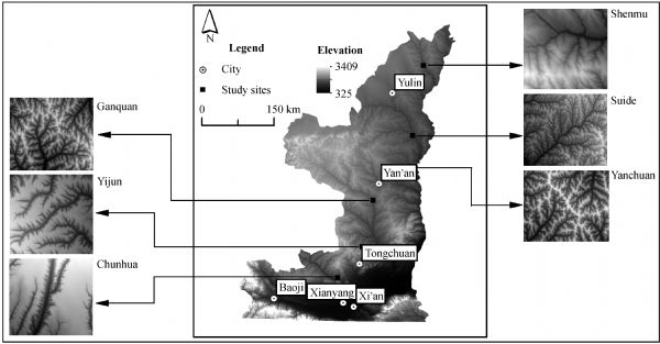
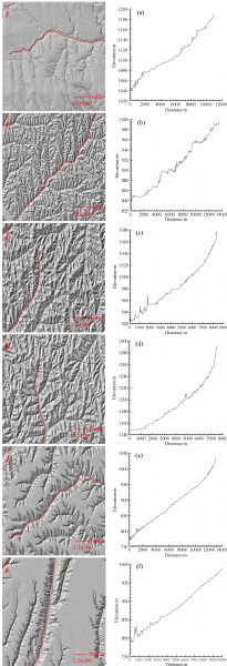
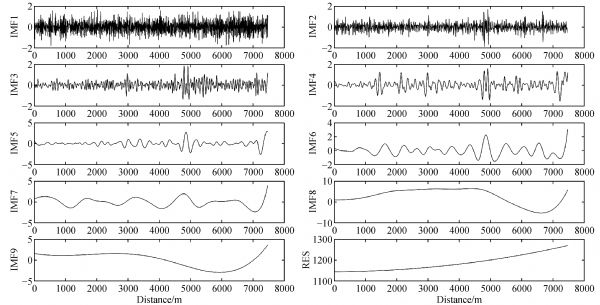
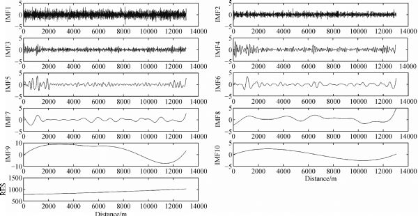
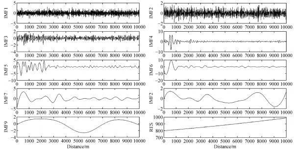
Abstract The Loess Plateau is densely covered by numerous types of gullies which represent different soil erosion intensities. Therefore, research on topographic variation features of the loess gullies is of great significance to environmental protection and ecological management. Using a 5 m digital elevation model and data from a national geographic database, this paper studies different topographical areas of the Loess Plateau, including Shenmu, Suide, Yanchuan, Ganquan, Yijun, and Chunhua, to derive representative gully terrain profile data of the sampled areas. First, the profile data are standardized in MATLAB and then decomposed using the ensemble empirical mode decomposition method. Then, a significance test is performed on the results; the test confidence is 95% to 99%. The most reliable decomposition component is then used to calculate the relief period and size of the gullies. The results showed that relief periods of the Chunhua, Shenmu, Yijun, Yuanchuan, Ganquan, and Suide gullies are 1110.14 m, 1096.85 m, 1002.49 m, 523.48 m, 498.12 m, and 270.83 m, respectively. In terms of gully size, the loess landforms are sorted as loess fragmented tableland, aeolian and dune, loess tableland, loess ridge, loess hill and loess ridge, and loess hill, in descending order. Taken together, the gully terrain features of the sample areas and the results of the study are approximately consistent with the actual terrain profiles. Thus, we conclude that ensemble empirical mode decomposition is a reliable method for the study of the relief and topography of loess gullies.
|
| Keywords
loess gully
DEM
terrain profile
EEMD
Loess Plateau
|
|
Corresponding Author(s):
Xuan FANG,Fayuan LI
|
|
Just Accepted Date: 29 November 2018
Online First Date: 27 December 2018
Issue Date: 16 May 2019
|
|
| 1 |
TAlexandrov (2009). A method of trend extraction using singular spectrum analysis. Revstat Stat J, 7(1): 1–22
|
| 2 |
J PAvouac, J F Dobremez, L Bourjot (1996). Palaeoclimatic interpretation of a topographic profile across middle Holocene regressive shorelines of Longmu Co (western Tibet). Palaeogeogr Palaeoclimatol Palaeoecol, 120(1–2): 93–104
https://doi.org/10.1016/0031-0182(96)88700-1
|
| 3 |
A YAyenu-Prah, N OAttoh-Okine (2009). Comparative study of Hilbert–Huang transform, Fourier transform and wavelet transform in pavement profile analysis. VehSystDyn, 47(4): 437–456
https://doi.org/10.1080/00423110802167466
|
| 4 |
HBlanco, R Lal (2010). Principles of Soil Conservation and Management. Springer, 1–19
|
| 5 |
D WBurbank (1992). Causes of recent Himalayan uplift deduced from deposited patterns in the Ganges basin. Nature, 357(6380): 680–683
https://doi.org/10.1038/357680a0
|
| 6 |
Q GCai (2001). Soil erosion and management on the Loess Plateau. J GeogrSci, 11(1): 53–70
https://doi.org/10.1007/BF02837376
|
| 7 |
JCao, J Na, JLi, GTang, X Fang, LXiong (2017). Topographic spatial variation analysis of loess shoulder lines in the Loess Plateau of China based on MF-DFA. ISPRS Int J Geoinf, 6(5): 141–159
https://doi.org/10.3390/ijgi6050141
|
| 8 |
Y ZChen (1984). The classification of gully in hilly loess region the middle reaches of the yellow river. Scientia Geographica Sinica, 4(4): 321–327 (in Chinese)
|
| 9 |
YChen, J P Wilson, Q Zhu, QZhou (2012). Comparison of drainage-constrained methods for DEM generalization. Comput Geosci, 48: 41–49
https://doi.org/10.1016/j.cageo.2012.05.002
|
| 10 |
YChen, Q Zhou (2013). A scale-adaptive DEM for multi-scale terrain analysis. Int J Geogr Inf Sci, 27(7): 1329–1348
https://doi.org/10.1080/13658816.2012.739690
|
| 11 |
HCheng, X Zou, YWu, CZhang, QZheng, ZJiang (2007). Morphology parameters of ephemeral gully in characteristics hillslopes on the Loess Plateau of China. Soil Tillage Res, 94(1): 4–14
https://doi.org/10.1016/j.still.2006.06.007
|
| 12 |
J DDavis, J D Chojnacki (2017). Two-dimensional discrete Fourier transform analysis of karst and coral reef morphologies. Trans GIS, 21(3): 521–545
https://doi.org/10.1111/tgis.12277
|
| 13 |
ADoglioni, V Simeone (2014). Geomorphometric analysis based on discrete wavelet transform. Environ Earth Sci, 71(7): 3095–3108
https://doi.org/10.1007/s12665-013-2686-3
|
| 14 |
EFielding, B Isacks, MBarazangi, CDuncan (1994). How flat is Tibet? Geology, 22(2): 163–167
https://doi.org/10.1130/0091-7613(1994)022<0163:HFIT>2.3.CO;2
|
| 15 |
PFrederiksen (1981). Terrain analysis and accuracy prediction by means of the Fourier transformation. Photogrammetria, 36(4): 145–157
https://doi.org/10.1016/0031-8663(81)90003-X
|
| 16 |
BFu, S Wang, YLiu, JLiu, W Liang, CMiao (2017). Hydrogeomorphic ecosystem responses to natural and anthropogenic changes in the Loess Plateau of China. Annu Rev Earth Planet Sci, 45(1): 223–243
https://doi.org/10.1146/annurev-earth-063016-020552
|
| 17 |
J THack (1973). Stream-profile analysis and stream-gradient index. J Res US GeolSurv, 1(4): 421–429
|
| 18 |
J THanley (1977). Fourier analysis of the Catawba Mountain knolls, Roanoke county, Virginia. J Int Assoc Math Geol, 9(2): 159–163
https://doi.org/10.1007/BF02312510
|
| 19 |
J MHarrison, C P Lo (1996). PC-based two-dimensional discrete Fourier transform programs for terrain analysis. Comput Geosci, 22(4): 419–424
https://doi.org/10.1016/0098-3004(95)00104-2
|
| 20 |
R EHorton (1945). Erosional development of streams and their drainage basins: hydrophysical approach to quantitative morphology. Geol Soc Am Bull, 56(3): 275–370
https://doi.org/10.1130/0016-7606(1945)56[275:EDOSAT]2.0.CO;2
|
| 21 |
N EHuang, Z Shen, S RLong, M CWu, H HShih, QZheng, H HLiu (1998). The empirical mode decomposition and the Hilbert spectrum for nonlinear and non-stationary time series analysis. In: Proceedings of the Royal Society of London A: Mathematical, Physical and Engineering Sciences, 454(1971): 903–995
|
| 22 |
WJiang, Z Han, JZhang, QJiao (2016). Stream profile analysis, tectonic geomorphology and neotectonic activity of the Damxung-Yangbajain rift in the south Tibetan Plateau. Earth Surf Process Landf, 41(10): 1312–1326
https://doi.org/10.1002/esp.3899
|
| 23 |
A LLei, K L Tang, W L Wang (2000). Significant and character of conception of soil erosion chain. J Soil Water Conserv, 14(3): 79–83(in Chinese)
|
| 24 |
FLi, G Tang, CWang, LCui, R Zhu (2016). Slope spectrum variation in a simulated loess watershed. Front Earth Sci, 10(2): 328–339
https://doi.org/10.1007/s11707-015-0519-2
|
| 25 |
X TLi, G X Zhu, H Q Cao, F Y Peng (2007). Anisotropy multi-scale self-similarity random field and terrain construction. Journal of Image and Graphics, 12(7): 1286–1290 (in Chinese)
|
| 26 |
Z LLi (2008). Multi-scale digital terrain modelling and analysis. In: Zhou Q, Lees B, Tang G, eds. Advances in Digital Terrain Analysis. Lecture Notes in Geoinformation and Cartography. Berlin, Heidelberg: Springer, 59–83
|
| 27 |
ZLi, Y Zhang, QZhu, YHe, W Yao (2015). Assessment of bank gully development and vegetation coverage on the Chinese Loess Plateau. Geomorphology, 228: 462–469
https://doi.org/10.1016/j.geomorph.2014.10.005
|
| 28 |
D SLiu, Z Ding, ZGuo (1991). Loess, Environment, and Global Change. Beijing: Science Press
|
| 29 |
Y BLiu, X M Zhu, P H Zhou (1988). The laws of hillslope channel erosion occurrence and development on loess plateau. Memoir of NISWC Academia Sinica, 7(1): 9–18 (in Chinese)
|
| 30 |
L XLuo (1956). A tentative classification of landforms in the Loess Plateau. J Geogr Sci, 22(3): 201–222
|
| 31 |
TMa, Y Chen, YHua, ZChen, X Chen, CLin, CYang (2017). DEM generalization with profile simplification in four directions. Earth Sci Inform, 10(1): 29–39
https://doi.org/10.1007/s12145-016-0275-1
|
| 32 |
J TPerron, J W Kirchner, W E Dietrich (2008). Spectral signatures of characteristic spatial scales and nonfractal structure in landscapes. J Geophys Res Earth Surf, 113(F4): F04003
|
| 33 |
R JPike, W J Rozema (1975). Spectral analysis of landforms. Ann Assoc Am Geogr, 65(4): 499–516
https://doi.org/10.1111/j.1467-8306.1975.tb01058.x
|
| 34 |
J NRayner (1972). The application of harmonic and spectral analysis to the study of terrain. In: Chorley R J, ed. Spatial Analysis in Geomorphology. London: Methuen & Co. Ltd., 283–302
|
| 35 |
WSun, Q Shao, JLiu, JZhai (2014). Assessing the effects of land use and topography on soil erosion on the Loess Plateau in China. Catena, 121: 151–163
https://doi.org/10.1016/j.catena.2014.05.009
|
| 36 |
TSvoray, H Markovitch (2009). Catchment scale analysis of the effect of topography, tillage direction and unpaved roads on ephemeral gully incision. Earth Surf Process Landf, 34(14): 1970–1984
https://doi.org/10.1002/esp.1873
|
| 37 |
KTang, K Zhang, ALei (1998). Critical slope gradient for compulsory abandonment of farmland on the hilly Loess Plateau. Chin Sci Bull, 43(5): 409–412
https://doi.org/10.1007/BF02883721
|
| 38 |
TTelbisz, G Kovács, BSzékely, JSzabó (2013). Topographic swath profile analysis: a generalization and sensitivity evaluation of a digital terrain analysis tool. Z Geomorphol, 57(4): 485–513
https://doi.org/10.1127/0372-8854/2013/0110
|
| 39 |
DTorri, J Poesen (2014). A review of topographic threshold conditions for gully head development in different environments. Earth Sci Rev, 130: 73–85
https://doi.org/10.1016/j.earscirev.2013.12.006
|
| 40 |
CValentin, J Poesen, YLi (2005). Gully erosion: impacts, factors and control. Catena, 63(2–3): 132–153
https://doi.org/10.1016/j.catena.2005.06.001
|
| 41 |
KVandaele, J Poesen, GGovers, Bvan Wesemael (1996). Geomorphic threshold conditions for ephemeral gully incision. Geomorphology, 16(2): 161–173
https://doi.org/10.1016/0169-555X(95)00141-Q
|
| 42 |
FWu (2003). Scale-dependent representations of relief based on wavelet analysis. Geo Spat Inf Sci, 6(1): 66–69
https://doi.org/10.1007/BF02826705
|
| 43 |
ZWu, N E Huang (2004). A study of the characteristics of white noise using the empirical mode decomposition method. In: Proceedings of the Royal Society of London A: Mathematical, Physical and Engineering Sciences, 460(2046): 1597–1611
|
| 44 |
ZWu, N E Huang (2005). Statistical significance test of intrinsic mode functions. Hilbert–Huang Transform and Its Applications. World Scientific Publishing Co. Pte. Ltd., 107–127
https://doi.org/10.1142/9789812703347_0005
|
| 45 |
ZWu, N E Huang (2009). Ensemble empirical mode decomposition: a noise-assisted data analysis method. Adv Adapt Data Anal, 1(1): 1–41
https://doi.org/10.1142/S1793536909000047
|
| 46 |
MXu, Q Li, GWilson (2016). Degradation of soil physicochemical quality by ephemeral gully erosion on sloping cropland of the hilly Loess Plateau, China. Soil Tillage Res, 155: 9–18
https://doi.org/10.1016/j.still.2015.07.012
|
| 47 |
QYu, J Tian, JLiu (2004). A NOVEL contour-based 3D terrain matching algorithm using wavelet transform. Pattern Recognit Lett, 25(1): 87–99
https://doi.org/10.1016/j.patrec.2003.09.004
|
| 48 |
H PZhang, S F Liu, Y P Sun, Y S Chen (2006a). The acquisition of local topographic relief and its application: an SRTM-DEM analysis. Remote Sensing for Land & Resources, 18(1): 31–35 (in Chinses)
|
| 49 |
H PZhang, S F Liu, N Yang, Y QZhang, G WZhang (2006b). Geomorphic characteristics of the Minjiang drainage basin (eastern Tibetan Plateau) and its tectonic implications: new insights from a digital elevation model study. Isl Arc, 15(2): 239–250
https://doi.org/10.1111/j.1440-1738.2006.00524.x
|
| 50 |
L TZhang, Z B Li, H Wang, J BXiao (2016a). Influence of intra-event-based flood regime on sediment flow behavior from a typical agro-catchment of the Chinese Loess Plateau. J Hydrol (Amst), 538: 71–81
https://doi.org/10.1016/j.jhydrol.2016.01.061
|
| 51 |
L TZhang, Z B Li, S S Wang (2016b). Spatial scale effect on sediment dynamics in basin-wide floods within a typical agro-watershed: a case study in the hilly loess region of the Chinese Loess Plateau. Sci Total Environ, 572: 476–486
https://doi.org/10.1016/j.scitotenv.2016.08.082
|
| 52 |
GZhao, X Mu, ZWen, FWang, P Gao (2013). Soil erosion, conservation, and eco-environment changes in the loess plateau of China. Land Degrad Dev, 24(5): 499–510
https://doi.org/10.1002/ldr.2246
|
| 53 |
S MZhao, W M Cheng, C H Zhou, X Chen (2009). Analysis on the topographic gradient and geographical meaning of Mt. Konggur, in the northern edge of Qinghai-Tibet Plateau. Journal of Geo-information Sciences, 11(6): 753–758 (in Chinese)
https://doi.org/10.3724/SP.J.1047.2009.00753
|
| 54 |
T XZhu (2012). Gully and tunnel erosion in the hilly Loess Plateau region, China. Geomorphology, 153–154: 144–155
https://doi.org/10.1016/j.geomorph.2012.02.019
|
| 55 |
X MZhu (1956). Classification on the soil erosion in the loess region. Acta Pedologica Sinica, 4(2): 99–115 (in Chinese)
|
| 56 |
B WZou, W F Ma, Y Long, S SHou, LZhang (2011). Extraction method of swath profile based on ArcGIS and its application in landform analysis. Geography and Geo-Information Science, 27(3): 42–44 (in Chinese)
|
|
Viewed |
|
|
|
Full text
|
|
|
|
|
Abstract
|
|
|
|
|
Cited |
|
|
|
|
| |
Shared |
|
|
|
|
| |
Discussed |
|
|
|
|