|
|
|
Spatial distribution of an ancient agricultural oasis in Juyan, northwestern China |
Ningke HU1,2,Xin LI1,*( ) ) |
1. Cold and Arid Regions Environmental and Engineering Research Institute, Chinese Academy of Sciences, Lanzhou 730000, China
2. College of Earth and Environmental Sciences, Lanzhou University, Lanzhou 730000, China |
|
|
|
|
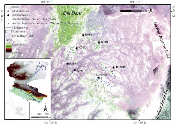
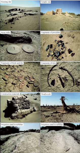
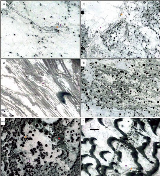
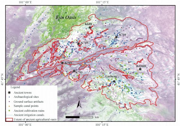
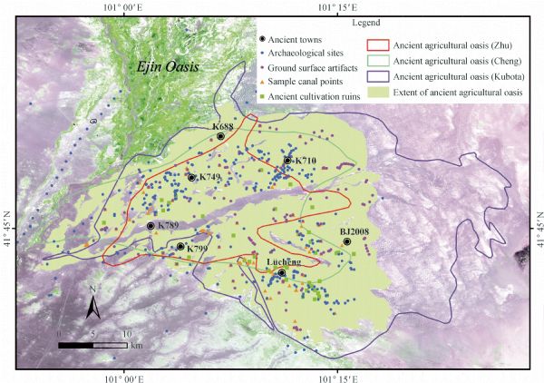
Abstract Activities related to agricultural cultivation are some of the major human drivers of landscape change on the Earth’s surface. Archaeological remains can provide qualitative evidence for studies of past agricultural development and environmental conditions. The ancient Juyan Oasis, which once flourished along the historic Silk Road, was a typical oasis of downstream inland river basins in the arid zone of northwestern China. Historical records and archaeological discoveries have qualitatively shown that the oasis supported extensive agricultural activities in this historical period from the Han Dynasty to the early Ming Dynasty (B.C. 202–A.D. 1375), which can be traced back to 2,000 years ago. In this study, different types of archaeological remains (including archaeological sites, ground surface artifacts, ancient cultivation ruins, and agricultural irrigation canals) that were obtained and identified from previous archaeological reports, field inspections, and remote sensing imagery were used to determine the spatial extent of the agricultural oasis in the historical period of interest. Our approach used multiple data sources in order to increase the accuracy and reliability of the results compared to previous studies. Our results distinctly suggested that much of the oasis was cultivated during the historical periods considered. Additionally, the arable land area in the historical period considered was roughly estimated to be approximately (3.39–4.75) × 104 ha. These findings regarding the spatial distribution of this ancient agricultural oasis and its arable land were reasonably determined to represent the ancient agricultural development that occurred in the Juyan Oasis better than results obtained from single sources of data.
|
| Keywords
archaeological remain
arable land
remote sensing
Juyan Oasis
Silk Road
|
|
Corresponding Author(s):
Xin LI
|
|
Issue Date: 04 July 2014
|
|
| 1 |
Alizadeh A, Kouchoukos N, Wilkinson T J, Bauer A M, Mashkour M (2004). Human-environmental interactions on the upper Khuzestan plains, southwest Iran, recent investigations. Paléorient, 30(1): 69–88
doi: 10.3406/paleo.2004.4773
|
| 2 |
Ban G (1962). (Han Dynasty): Han Shu. Beijing: Zhonghua Book Company, 1534, 1613
|
| 3 |
CCEC (Compilation Committee of Ejin Chorography) (1998). Ejin Chorography. Beijing: Chorography Press, 48–50, 739–759
|
| 4 |
Cheng H Y (2007). Desertification of the Hexi Area in historical time. Dissertation for Ph.D degree. Lanzhou: Lanzhou University
|
| 5 |
Cheng W M, Zhou C H, Liu H J, Zhang Y, Jiang Y, Zhang Y C, Yao Y H (2006). The oasis expansion and eco-environment change over the last 50 years in Manas River Valley, Xinjiang. Sci China Series D, 49(2): 163–175
|
| 6 |
Fang J Q, Liu G (1992). Relationship between climatic change and the nomadic southward migrations in eastern Asia during historical times. Clim Change, 22(2): 151–168
doi: 10.1007/BF00142964
|
| 7 |
Fang X L (1974). (Jin Dynasty): Jin Shu. Beijing: Zhonghua Book Company, 434
|
| 8 |
Goldewijk K K, Ramankutty N (2004). Land cover change over the last three centuries due to human activities: the availability of new global data set. GeoJournal, 61(4): 335–344
doi: 10.1007/s10708-004-5050-z
|
| 9 |
Hedin S, Bergman F (1944). History of the Expedition in Asia, 1927–1935. Stockholm: Statens Etnografiska Museum, 146
|
| 10 |
Hu X L (2012). Investigation on dynamic changes of ecological environment in the middle and lower reaches in Heihe River Basin. The Heihe River Basin Authority of the Yellow River Water Conservancy Committee, Cold and Arid Regions Environmental and Engineering Research Institute, Chinese Academy of Sciences
|
| 11 |
Kang S Z, Su X L, Tong L, Zhang J H, Zhang L, Davies W J (2008). A warning from an ancient oasis: intensive human activities are leading to potential ecological and social catastrophe. Int J Sustain Dev World Ecol, 15(5): 440–447
doi: 10.3843/SusDev.15.5:5
|
| 12 |
Kubota J (2010). Effects of human activities on the hydrological processes in arid regions of central Eurasia: a multi-disciplinary research project. CAREERI Report
|
| 13 |
Lan L, Mu G J, Qi W Y, Hidehiro S, Murata T (2009). Characteristics of paleo-irrigation channels from Han to Xixia Dynasties on remote sensing images and environment changes in ancient Juyan. Quaternary Sciences, 29(2): 241–246 (in Chinese)
|
| 14 |
Li B C (2003). Study of the Desertification in Hexi Corridor in Historical Period. Beijing: Science Press, 32–47, 199–209
|
| 15 |
Li J P (1983). (Tang Dynasty): The Annals of Yuanhe County. Beijing: Zhonghua Book Company, 1020–1022
|
| 16 |
Li Y Y (1991). Manuscripts Unearthed in Khara Khoto (in Chinese Volume). Beijing: Science Press,15–20
|
| 17 |
Liu B, Zhao W Z, Chang X X, Li S B, Zhang Z H, Du M W (2010a). Water requirements and stability of oasis ecosystem in arid region, China. Environmental Earth Sciences, 59(6): 1235–1244
doi: 10.1007/s12665-009-0112-7
|
| 18 |
Liu W, Cao S K, Xi H Y, Feng Q (2010b). Land use history and status of land desertification in the Heihe River basin. Nat Hazards, 53(2): 273–290
doi: 10.1007/s11069-009-9429-5
|
| 19 |
Luo S J (2003). Investigation and Remotely Sensed Observation of Ruins of Han Dynasty in Juyan. Taipei: Taiwan Ancient Books Publishing Co. Ltd, 87–123
|
| 20 |
McAllister L S (2008). Reconstructing historical riparian conditions of two river basins of eastern Oregon, USA. Environ Manage, 42(3): 412–425
doi: 10.1007/s00267-008-9127-1
|
| 21 |
Miao L L, Cai W B, Wang A M (2002). On evolution of man-land system in oasis. Chin Geogr Sci, 12(3): 199–205
doi: 10.1007/s11769-002-0002-3
|
| 22 |
Nelson M C, Kintigh K, Abbott D R, Anderies J M (2010). The cross-scale interplay between social and biophysical context and the vulnerability of irrigation-dependent societies: archaeology’s long-term perspective. Ecology and Society, 15(3): 31
|
| 23 |
Nouri J, Mirbagheri S A, Farrokhian F, Jaafarzadeh N, Alesheikh A A (2010). Water quality variability and eutrophic state in wet and dry years in wetlands of the semiarid and arid regions. Environmental Earth Sciences, 59(7): 1397–1407
doi: 10.1007/s12665-009-0126-1
|
| 24 |
Qi W Y, Endo K, Sohma H, Mu G J, Taisuke M, Hori K, Zheng X M, Nakawo M (2007). Lake level changes and its cause in historical period based on the pollen analysis in the lowest reaches of Heihe River, China. In: Shen W R, Nakawo M, Shi J B, eds. Research on Humanities and Environment of Khara Khoto. Beijing: Renmin University Press, 253–273
|
| 25 |
Qin X G, Liu J Q, Jia H J, Lu H Y, Xia X C, Zhou L P, Mu G J, Xu Q H, Jiao Y X (2012). New evidence of agricultural activity and environmental change associated with the ancient Loulan kingdom, China, around 1500 years ago. Holocene, 22(1): 53–61
doi: 10.1177/0959683611405234
|
| 26 |
Ramankutty N, Foley J A (1999). Estimating historical changes in global land cover: croplands from 1700 to 1992. Global Biogeochem Cycles, 13(4): 997–1027
doi: 10.1029/1999GB900046
|
| 27 |
Sakai A, Inoue M, Fujita K, Narama C, Kubota J, Nakawo M, Yao T D (2012). Variations in discharge from the Qilian mountains, northwest China, and its effect on the agricultural communities of the Heihe basin, over the last two millennia. Water History, 4(2): 177–196
doi: 10.1007/s12685-012-0057-8
|
| 28 |
SBCR (State Bureau of Cultural Relics) (2003). Cultural Relics Atlas of China (Branch of Inner Mongolia Autonomous Region). Xi’an: Xi’an Map Publishing House, 276–277
|
| 29 |
Shi C C, Yong G W, Zhou H M, Ren G Y, Li H C, Zeng L X (1993). Research and application of measuring method for cultivated land. Southwest China Journal of Agricultural Sciences, 6(2): 44–48 (in Chinese)
|
| 30 |
Sohma H, Tian R, Wei J, Moriya K, Iguro S, Ito T (2009). Unrecognized ruins interpreted from the high-resolution satellite images and their significance, in case of the lower reaches of the Heihe River, Inner Mongolia, China. The Association of Japanese Geographers, 7: 106 (in Japanese)
|
| 31 |
Sommarstrom B (1956–1958). Archaeological Researches in the Edsen-Gol Region Inner Mongolia. Stockholm: Statens Etnografiska Museum
|
| 32 |
Stein A (1928). Innermost Asia, Detailed Report of Explorations in Central Asia, Kan-su and Eastern Iran. Oxford: The Clarendon Press
|
| 33 |
Turner B L (1974). Prehistoric intensive agriculture in the Mayan Lowlands. Science, 185(4146): 118–124
doi: 10.1126/science.185.4146.118
|
| 34 |
Wang G X, Cheng G D (1999). Water resources development and its influence on the environment in arid areas of China–Case of the Hei River Basin. J Arid Environ, 43(2): 121–131
doi: 10.1006/jare.1999.0563
|
| 35 |
Wang X M, Xiao H L, Li J C, Qiang M R, Su Z Z (2008). Nebkha development and its relationship to environmental change in the Alaxa Plateau, China. Environmental Geology, 56(2): 359–365
doi: 10.1007/s00254-007-1171-2
|
| 36 |
Wang X M, Zhang C X, Zhang J W, Hua T, Lang L L, Zhang X Y, Wang L (2010). Nebkha formation: implications for reconstructing environmental changes over the past several centuries in the Ala Shan Plateau, China. Palaeogeogr Palaeoclimatol Palaeoecol, 297(3–4): 697–706
doi: 10.1016/j.palaeo.2010.09.020
|
| 37 |
Wu H Q (2002). Irrigation canals and related issues founded in the Manuscripts unearthed in Khara Khoto. In: Zhou W Z, eds. The First Series of Northwest Ethnic History. Beijing: China Social Sciences Press, 129–145
|
| 38 |
Xiao S C, Xiao H L, Si J H, Ji X B, Liu F M (2005). Lake level changes recorded by tree rings of lakeshore shrubs: a case study at the Lake West-Juyan, Inner Mongolia, China. J Integr Plant Biol, 47(11): 1303–1314
doi: 10.1111/j.1744-7909.2005.00190.x
|
| 39 |
Xie Y W, Chen F H, Qi J G (2009). Past desertification processes of Minqin Oasis in arid China. Int J Sustain Dev World Ecol, 16(4): 260–269
doi: 10.1080/13504500903132309
|
| 40 |
Xie Y W, Wang X Q, Wang G S, Yu L (2013). Cultivated land distribution simulation based on grid in middle reaches of Heihe River Basin in the historical periods. Advances in Earth Science, 28(1): 71–78 (in Chinese)
|
| 41 |
Xue Y Q (1991). General Theory of Han Dynasty Slips. Lanzhou: Gansu Education Publishing House, 55–56
|
| 42 |
Yang B, Qin C, Shi F, Sonechkin D M (2011). Tree ring-based annual streamflow reconstruction for the Heihe River in arid northwestern China from AD 575 and its implications for water resource management. Holocene, 22(8): 773–784
|
| 43 |
Yang F (2006). Juyan frontier fortress’ function at the resisting the Huns in the Han Dynasty. Journal of Hexi University, 22: 13–16 (in Chinese)
|
| 44 |
Yang X (2001). The oases along the Keriya River in the Taklamakan Desert, China, and their evolution since the end of the last glaciation. Environmental Geology, 41(3–4): 314–320
doi: 10.1007/s002540100388
|
| 45 |
Yu P J, Xu H L, Qiao M, Zhou S B, An H Y (2009). Arable land in the Manas River Basin based on CBERS data. Arid Zone Research, 26(6): 846–851 (in Chinese)
doi: 10.3724/SP.J.1148.2009.00846
|
| 46 |
Yu Y Y, Guo Z T, Wu H B, Finke P A (2012). Reconstructing prehistoric land use change from archaeological data: validation and application of a new model in Yiluo valley, northern China. Agric Ecosyst Environ, 156(1): 99–107
doi: 10.1016/j.agee.2012.05.013
|
| 47 |
Yue B H (1984). Surveyed report on fier beacon ruins of Han Dynasty in the downstream of Ejin River. In: Archaeological Team of Gansu Province and Gansu Provincial Museum, eds. Study Series of Bamboo Slips. Lanzhou: Gansu People’s Publishing House, 61–84
|
| 48 |
Zhang H, Wu J W, Zheng Q H, Yu Y J (2003). A preliminary study of oasis evolution in the Tarim Basin, Xinjiang, China. J Arid Environ, 55(3): 545–553
doi: 10.1016/S0140-1963(02)00283-5
|
| 49 |
Zhang L (2001). A study on the environmental changes of the ancient Lou-Lan oasis from the Han to the Jin Dynasty. Dissertation for MSc degree. Xi’an: Shaanxi Normal University
|
| 50 |
Zhang Q Q, Xu H L, Li Y, Fan Z L, Zhang P, Yu P J, Ling H B (2012). Oasis evolution and water resource utilization of a typical area in the inland river basin of an arid area: a case study of the Manas River valley. Environmental Earth Sciences, 66(2): 683–692
doi: 10.1007/s12665-011-1276-5
|
| 51 |
Zhang X Y, Wang X M, Yan P (2008). Re-evaluating the impacts of human activity and environmental change on desertification in the Minqin Oasis, China. Environmental Geology, 55(4): 705–715
doi: 10.1007/s00254-007-1022-1
|
| 52 |
Zhong F L, Xu Z M, Cheng H W, Ge Y C (2011). The history of water resources utilization and management in the middle reaches of Heihe River. Journal of Glaciology and Geocryology, 33(3): 692–701 (in Chinese)
|
| 53 |
Zhu Z D, Liu S, Gao Q Z, Hu Z Y, Yang Y L (1983). The environmental changes and desertification processes in historical period in the areas of ancient Juyan-Heicheng region in western Inner Mongolia. J Desert Res, 3(2): 1–8 (in Chinese)
|
| 54 |
Zu R P, Gao Q Z, Qu J J, Qiang M R (2003). Environmental changes of oases at southern margin of Tarim Basin, China. Environmental Geology, 44(6): 639–644
doi: 10.1007/s00254-003-0808-z
|
|
Viewed |
|
|
|
Full text
|
|
|
|
|
Abstract
|
|
|
|
|
Cited |
|
|
|
|
| |
Shared |
|
|
|
|
| |
Discussed |
|
|
|
|