|
|
|
Developing a USLE cover and management factor (C) for forested regions of southern China |
Conghui LI1, Lili LIN1,2, Zhenbang HAO1,2, Christopher J. POST3, Zhanghao CHEN1,2, Jian LIU1,2, Kunyong YU1,2( ) ) |
1. Fujian Agriculture and Forestry University, Fuzhou 350002, China
2. University Key Laboratory for Geomatics Technology and Optimized Resources Utilization in Fujian Province, Fuzhou 350002, China
3. Department of Forestry and Environmental Conservation, Clemson University, Clemson SC 29634, USA |
|
|
|
|
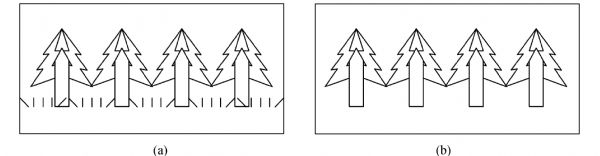
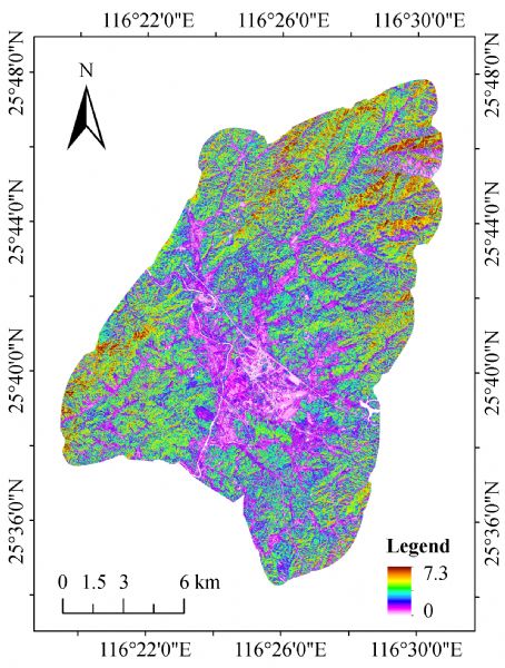
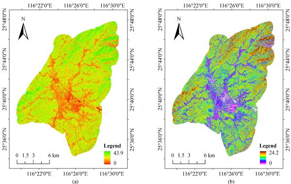
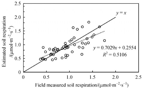
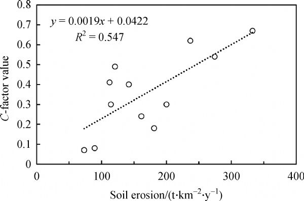
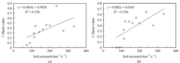
Abstract The Universal Soil Loss Equation model is often used to improve soil resource conservation by monitoring and forecasting soil erosion. This study tested a novel method to determine the cover and management factor (C) of this model by coupling the leaf area index (LAI) and soil basal respiration (SBR) to more accurately estimate a soil erosion map for a typical region with red soil in Hetian, Fujian Province, China. The spatial distribution of the LAI was obtained using the normalized difference vegetation index and was consistent with the LAI observed in the field (R2 = 0.66). The spatial distribution of the SBR was obtained using the Carnegie–Ames–Stanford Approach model and verified by soil respiration field observations (R2 = 0.51). Correlation analyses and regression models suggested that the LAI and SBR could reasonably reflect the structure of the forest canopy and understory vegetation, respectively. Finally, the C-factor was reconstructed using the proposed forest vegetation structure factor (Cs), which considers the effect of the forest canopy and shrub and litter layers on reducing rainfall erosion. The feasibility of this new method was thoroughly verified using runoff plots (R2 = 0.55). The results demonstrated that Cs may help local governments understand the vital role of the structure of the vegetation layer in limiting soil erosion and provide a more accurate large-scale quantification of the C-factor for soil erosion.
|
| Keywords
leaf area index
remote sensing
soil basal respiration
forest vegetation structure factor
vegetation layer structure
|
|
Corresponding Author(s):
Kunyong YU
|
|
Online First Date: 23 November 2020
Issue Date: 04 December 2020
|
|
| 1 |
T K Alexandridis, A M Sotiropoulou, G Bilas, N Karapetsas, N G Silleos (2015). The effects of seasonality in estimating the C-factor of soil erosion studies. Land Degrad Dev, 26(6): 596–603
https://doi.org/10.1002/ldr.2223
|
| 2 |
J A Anache, E C Wendland, P T Oliveira, D C Flanagan, M A Nearing (2017). Runoff and soil erosion plot-scale studies under natural rainfall: a meta-analysis of the Brazilian experience. Catena, 152: 29–39
https://doi.org/10.1016/j.catena.2017.01.003
|
| 3 |
A Arar, H Chenchouni (2014). A “simple” geomatics-based approach for assessing water erosion hazard at montane areas. Arab J Geosci, 7(1): 1–12
https://doi.org/10.1007/s12517-012-0782-4
|
| 4 |
V Arora (2002). Modeling vegetation as a dynamic component in soil–vegetation–atmosphere transfer schemes and hydrological models. Rev Geophys, 40(2): 1–26
|
| 5 |
L Benkobi, M J Trlica, J L Smith (1994). Evaluation of a refined surface cover subfactor for use in RUSLE. Rangeland Ecol Manag, 47(1): 74–78
https://doi.org/10.2307/4002845
|
| 6 |
Z H Bu, H F Zhao, S Q Liu, M H Chen (1993). Preliminary study on algorithm formula of vegetative factor for undisturbed areas in remote sensing monitoring soil loss. Remote Sensing Technology and Application, 8(4): 16–22 (in Chinese)
|
| 7 |
C F Cai, S W Ding, Z H Shi, L Huang, G Y Zhang (2000). Study of applying USLE and geographical information system IDRISI to predict soil erosion in small watershed. J Soil Water Conserv, 14(2): 19–24 (in Chinese)
|
| 8 |
S F Chen, X Zha, Y H Bai, L Y Wang (2019). Evaluation of soil erosion vulnerability on the basis of exposure, sensitivity, and adaptive capacity: a case study in the Zhuxi watershed, Changting, Fujian Province, southern China. Catena, 177: 57–69
https://doi.org/10.1016/j.catena.2019.01.036
|
| 9 |
L Cyr, F Bonn, A Pesant (1995). Vegetation indices derived from remote sensing for an estimation of soil protection against water erosion. Ecol Modell, 79(1–3): 277–285
https://doi.org/10.1016/0304-3800(94)00182-H
|
| 10 |
C P Devatha, V Deshpande, M S Renukaprasad (2015). Estimation of soil loss using USLE model for Kulhan Watershed, Chattisgarh—a case study. Aquatic Procedia, 4: 1429–1436
https://doi.org/10.1016/j.aqpro.2015.02.185
|
| 11 |
W J Elliot (2004). WEPP internet interfaces for forest erosion prediction. J Am Water Resour Assoc, 40(2): 299–309
https://doi.org/10.1111/j.1752-1688.2004.tb01030.x
|
| 12 |
Q Feng, W W Zhao, J Y Ding, X N Fang, X Zhang (2018). Estimation of the cover and management factor based on stratified coverage and remote sensing indices: a case study in the Loess Plateau of China. J Soils Sediments, 18(3): 775–790
https://doi.org/10.1007/s11368-017-1783-4
|
| 13 |
W T Feng, X M Zou, L Q Sha, J H Chen, Z L Feng, J Z Li (2008). Comparisons between seasonal and diurnal patterns of soil respiration in a montane evergreen broad-leaved forest of Ailao mountains. J Plant Ecol, 32: 31–39 (in Chinese)
|
| 14 |
H S Gelagay, A S Minale (2016). Soil loss estimation using GIS and Remote sensing techniques: a case of Koga watershed, Northwestern Ethiopia. ISWCR, 4(2): 126–136
https://doi.org/10.1016/j.iswcr.2016.01.002
|
| 15 |
A Hursh, A Ballantyne, L Cooper, M Maneta, J Kimball, J Watts (2017). The sensitivity of soil respiration to soil temperature, moisture, and carbon supply at the global scale. Glob Change Biol, 23(5): 2090–2103
https://doi.org/10.1111/gcb.13489
pmid: 27594213
|
| 16 |
M D Jewell, B Shipley, E Low-Décarie, C M Tobner, A Paquette, C Messier, P B Reich (2017). Partitioning the effect of composition and diversity of tree communities on leaf litter decomposition and soil respiration. Oikos, 126(7): 959–971
https://doi.org/10.1111/oik.03868
|
| 17 |
H Jiang (2005). Soil erosion monitoring and eco-security evaluation on Changting. Dissertation for the Master’s Degree. Fuzhou: Fuzhou University (in Chinese)
|
| 18 |
Z S Jiang, Z Q Wang, Z Liu (1996). Study on the use of GIS to estimate soil erosion in a small watershed in the loess hilly region. Research of Soil and Water Conservation, 3(2): 84–97 (in Chinese)
|
| 19 |
Z M Jiao, X L Zhang, F L Li, K Shi, L L Ning, Y T Wang, M Y Zhao (2014). Impact of multispectral bands texture on leaf area index using Landsat-8. Geography and Geo-Information Science, 30(3): 42–45 (in Chinese)
|
| 20 |
Y Kang, M Özdoğan, S C Zipper, M O Román, J Walker, S Y Hong, M Marshall, V Magliulo, J Moreno, L Alonso, A Miyata, B Kimball, S P Loheide (2016). How universal is the relationship between remotely sensed vegetation indices and crop leaf area index? A global assessment. Remote Sens (Basel), 8(7): 597
https://doi.org/10.3390/rs8070597
pmid: 30002923
|
| 21 |
L J Lan (2012). Study on ecological restoration treatments of degraded red soil in Western Fujian Province. Dissertation for the Master’s Degree. Fuzhou: Fujian Agriculture and Forestry University (in Chinese)
|
| 22 |
I J Larsen, L H MacDonald (2007). Predicting postfire sediment yields at the hillslope scale: testing RUSLE and disturbed WEPP. Water Resour Res, 43(11):W11412
https://doi.org/10.1029/2006WR005560
|
| 23 |
W N Lei, Z M Wen (2008). Research on soil erosion vegetation factor index based on community structure. J Soil Water Conserv, 22(5): 68–72 (in Chinese)
|
| 24 |
C Lin, S L Zhou, S H Wu, F Q Liao (2012). Relationships between intensity gradation and evolution of soil erosion: a case study of Changting in Fujian Province, China. Pedosphere, 22(2): 243–253
https://doi.org/10.1016/S1002-0160(12)60011-3
|
| 25 |
J Lin, J C Zhang, Z Y Gu, Y M Wu (2013). Quantitative assessment of vegetation cover and management factor based on leaf area index and remote sensing. Sci Silva Sin, 49(2): 86–92 (in Chinese)
|
| 26 |
H Liu, S Blagodatsky, M Giese, F Liu, J Xu, G Cadisch (2016). Impact of herbicide application on soil erosion and induced carbon loss in a rubber plantation of southwest China. Catena, 145: 180–192
https://doi.org/10.1016/j.catena.2016.06.007
|
| 27 |
J Liu (2006). Study on the efficient spatial allocation of the ecological forest system in Minjiang watershed based on geomatics. Dissertation for the Doctoral Degree. Beijing: Beijing Forestry University (in Chinese)
|
| 28 |
S R Liu, Q S Guo, B Wang (1998). Prediction of net primary productivity of forests in China in response to climate change. Acta Ecol Sin, 18(5): 478–483 (in Chinese)
|
| 29 |
Y Luo, S Wan, D Hui, L L Wallace (2001). Acclimatization of soil respiration to warming in a tall grass prairie. Nature, 413(6856): 622–625
https://doi.org/10.1038/35098065
pmid: 11675783
|
| 30 |
B Ma, C D Li, Z B Li, F Q Wu (2016). Effects of crops on runoff and soil loss on sloping farmland under simulated rainfall. CLEAN–Soil Air Water, 44(7): 849–857
https://doi.org/10.1002/clen.201400241
|
| 31 |
M A Mohamadi, A Kavian (2015). Effects of rainfall patterns on runoff and soil erosion in field plots. Int Soil Water Conserv Res, 3(4): 273–281
https://doi.org/10.1016/j.iswcr.2015.10.001
|
| 32 |
D R Montgomery (2007). Soil erosion and agricultural sustainability. Proc Natl Acad Sci USA, 104(33): 13268–13272
https://doi.org/10.1073/pnas.0611508104
pmid: 17686990
|
| 33 |
H Park, S Lim, J Kwak, H Yang, K Lee, Y Lee, H Kim, W Choi (2018). Elevated CO2 concentration affected pine and oak litter chemistry and the respiration and microbial biomass of soils amended with these litters. Biol Fertil Soils, 54(5): 583–594
https://doi.org/10.1007/s00374-018-1282-9
|
| 34 |
Y Qi, M Xu, J G Wu (2002). Temperature sensitivity of soil respiration and its effects on ecosystem carbon budget: nonlinearity begets surprises. Ecol Modell, 153(1–2): 131–142
https://doi.org/10.1016/S0304-3800(01)00506-3
|
| 35 |
S M H Raza, S A Mahmood (2018). Estimation of net rice production through improved CASA model by addition of soil suitability constant (ha). Sustainability, 10(6): 1788
https://doi.org/10.3390/su10061788
|
| 36 |
K G Renard (1997). Predicting Soil Erosion by Water: A Guide to Conservation Planning with the Revised Universal Soil Loss Equation (RUSLE). Washington D.C: United States Government Printing
|
| 37 |
A Rey, E Pegoraro, V Tedeschi, I De Parri, P G Jarvis, R Valentini (2002). Annual variation in soil respiration and its components in a coppice oak forest in Central Italy. Glob Change Biol, 8(9): 851–866
https://doi.org/10.1046/j.1365-2486.2002.00521.x
|
| 38 |
C Ricotta, G Avena, A De Palma (1999). Mapping and monitoring net primary productivity with AVHRR NDVI time-series: statistical equivalence of cumulative vegetation indices. ISPRS J Photogram, 54(5–6): 325–331
https://doi.org/10.1016/S0924-2716(99)00028-3
|
| 39 |
L M Risse, M A Nearing, J M Laflen, A D Nicks (1993). Error assessment in the universal soil loss equation. Soil Sci Soc Am J, 57(3): 825–833
https://doi.org/10.2136/sssaj1993.03615995005700030032x
|
| 40 |
P Tripathi, N R Patel, S P S Kushwaha (2018). Estimating net primary productivity in tropical forest plantations in India using satellite-driven ecosystem model. Geocarto Int, 33(9): 988–999
https://doi.org/10.1080/10106049.2017.1323963
|
| 41 |
S Trumbore, E S Da Costa, D C Nepstad, P Barbosa De Camargo, L A Martinelli, D Ray, T Restom, W Silver (2006). Dynamics of fine root carbon in Amazonian tropical ecosystems and the contribution of roots to soil respiration. Glob Change Biol, 12(2): 217–229
https://doi.org/10.1111/j.1365-2486.2005.001063.x
|
| 42 |
D P Turner, W D Ritts, W B Cohen, T K Maeirsperger, S T Gower, A A Kirschbaum, S W Running, M Zhao, S C Wofsy, A L Dunn, B E Law, J L Campbell, W C Oechel, H J Kwon, T P Meyers, E E Small, S A Kurc, J A Gamon (2005). Site-level evaluation of satellite-based global terrestrial gross primary production and net primary production monitoring. Glob Change Biol, 11(4): 666–684
https://doi.org/10.1111/j.1365-2486.2005.00936.x
|
| 43 |
J M Vose, P V Bolstad (2007). Biotic and abiotic factors regulating forest floor CO2 flux across a range of forest age classes in the southern Appalachians. Pedobiologia (Jena), 50(6): 577–587
https://doi.org/10.1016/j.pedobi.2006.10.006
|
| 44 |
R Wang, Q Sun, Y Wang, Q Liu, L Du, M Zhao, X Gao, Y Hu, S Guo (2017). Temperature sensitivity of soil respiration: synthetic effects of nitrogen and phosphorus fertilization on Chinese Loess Plateau. Sci Total Environ, 574: 1665–1673
https://doi.org/10.1016/j.scitotenv.2016.09.001
pmid: 27614858
|
| 45 |
X X Wang, T Sun, Q J Zhu, X Liu, F F Gao, Y M Hu, S H Chen (2014). Assessment of different methods for estimating forest leaf area index from remote sensing data. Acta Ecol Sin, 34(16): 4612–4619 (in Chinese)
|
| 46 |
Z J Wang, J Y Jiao, S Rayburg, Q L Wang, Y Su (2016). Soil erosion resistance of “Grain for Green” vegetation types under extreme rainfall conditions on the Loess Plateau, China. Catena, 141: 109–116
https://doi.org/10.1016/j.catena.2016.02.025
|
| 47 |
Z M Wen, G L Brian, F Jiao, W N Lei, H J Shi (2010). Stratified vegetation cover index: a new way to assess vegetation impact on soil erosion. Catena, 83(1): 87–93
https://doi.org/10.1016/j.catena.2010.07.006
|
| 48 |
W H Wischmeier, D D Smith (1978). Predicting Rainfall Erosion Losses: A Guide to Conservation Planning. Washington D C: US Department of Agriculture
|
| 49 |
Q Y Xie, J Dash, W J Huang, D L Peng, Q M Qin, H Mortimer, R Casa, S Pignatti, G Laneve, S Pascucci, Y Y Dong, H C Ye (2018). Vegetation indices combining the red and red-edge spectral information for leaf Area index retrieval. IEEE J-stars, 11(5): 1482–1493
https://doi.org/10.1109/JSTARS.2018.2813281
|
| 50 |
H Q Xu, X J Hu, H D Guan, B B Zhang, M Y Wang, S M Chen, M H Chen (2019). A remote sensing based method to detect soil erosion in forests. Remote Sens, 11(5): 513
https://doi.org/10.3390/rs11050513
|
| 51 |
X Yao, K Y Yu, G Y Wang, Y B Deng, Z J Lai, Y Chen, Y S Jiang, J Liu (2019). Effects of soil erosion and reforestation on soil respiration, organic carbon and nitrogen stocks in an eroded area of southern China. Sci Total Environ, 683: 98–108
https://doi.org/10.1016/j.scitotenv.2019.05.221
pmid: 31129335
|
| 52 |
K Y Yu, X Yao, Y B Deng, Z J Lai, L C Lin, J Liu (2019). Effects of stand age on soil respiration in Pinus massoniana plantations in the hilly red soil region of southern China. Catena, 178: 313–321
https://doi.org/10.1016/j.catena.2019.03.038
|
| 53 |
S Yuan, Y H Zheng, S B Wu, P Xu, F F Zhang, F X Kong, Y D Qi, D Wang (2018). March SST reconstruction in the South China Sea based on Pinus massoniana tree-ring widths from Changting, Fujian, in southeast China since 1893 CE. Mar Micropaleontol, 145: 21–27
https://doi.org/10.1016/j.marmicro.2018.10.003
|
| 54 |
Z P Yu, X H Wan, Z H Hu (2014). Contrasting responses of soil respiration to litter manipulation in subtropical Mytilaria laosensis and Cunninghamia lanceolata plantations. Acta Ecol Sin, 34: 2529–2538 (in Chinese)
|
| 55 |
C Zhang, G Xie, C Liu, C Lu (2011). Assessment of soil erosion under woodlands using USLE in China. Front Earth Sci, 5(2): 150–161
https://doi.org/10.1007/s11707-011-0158-1
|
| 56 |
H Zhang, D Yu, L Dong, X Shi, E Warner, Z Gu, J Sun (2014 a). Regional soil erosion assessment from remote sensing data in rehabilitated high density canopy forests of southern China. Catena, 123: 106–112
https://doi.org/10.1016/j.catena.2014.07.013
|
| 57 |
Y J Zhang, Z T Gan, R J Li, R Wang, N N Li, M Zhao, L L Du, S L Guo, J S Jiang, Z Q Wang (2016). Litter production rates and soil moisture influences interannual variability in litter respiration in the semi-arid Loess Plateau, China. J Arid Environ, 125: 43–51
https://doi.org/10.1016/j.jaridenv.2015.09.016
|
| 58 |
Y L Zhang, C H Song, K R Zhang, X L Cheng, L E Band, Q F Zhang (2014 b). Effects of land use/land cover and climate changes on terrestrial net primary productivity in the Yangtze River Basin, China, from 2001 to 2010. J Geophys Res Biogeosci, 119(6): 1092–1109
https://doi.org/10.1002/2014JG002616
|
| 59 |
H Zheng, F L Chen, Z Y Ouyang, N M Tu, W H Xu, X K Wang, H Miao, X Q Li, Y X Tian (2008). Impacts of reforestation approaches on runoff control in the hilly red soil region of Southern China. J Hydrol (Amst), 356(1–2): 174–184
https://doi.org/10.1016/j.jhydrol.2008.04.007
|
| 60 |
T Zhou, P J Shi, J Y Luo, Z Y Shao (2007). Estimation of soil organic carbon based on remote sensing and process model. Journal of Remote Sensing, 11(1): 127–136 (in Chinese)
|
|
Viewed |
|
|
|
Full text
|
|
|
|
|
Abstract
|
|
|
|
|
Cited |
|
|
|
|
| |
Shared |
|
|
|
|
| |
Discussed |
|
|
|
|